
Vogt WeatherWatcher
39.6K posts

Vogt WeatherWatcher
@VWeatherWatcher
A weather service dedicated to the Poconos specializing in school predictions. Supported by an awesome community. Predictions are my own opinion. #InVogtWeTrust
Northeastern Pennsylvania Katılım Nisan 2013
937 Takip Edilen9.6K Takipçiler
Sabitlenmiş Tweet

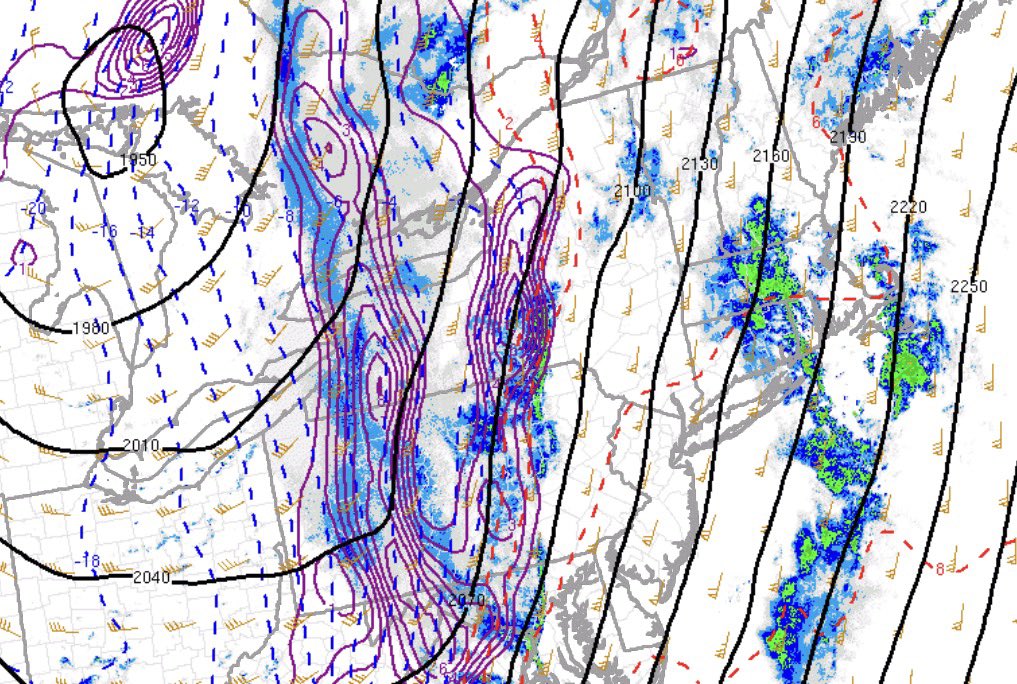
With a winter storm on the way, this is a great time to sign up for Premium!
✅School predictions for all districts in PA.
✅Zip Code predictions with weather graphs.
✅County-level predictions for the Northeast USA.
✅The original NEPA-focused graphics.
#_ga=2.201036331.481743964.1768958416-1388993842.1705888132" target="_blank" rel="nofollow noopener">vogtweatherwatcher.memberful.com/checkout?plan=…
English
Vogt WeatherWatcher retweetledi

Rain is transitioning to heavy snow as our front pushes through Pennsylvania.
Snow reports out of Western Pennsylvania have been around 2-4”+. Comparing current observations to some of the mesoscale guidance, it appears that the transition to frozen precipitation is moving quicker than modeled.
This is likely because of the abundant frontogenesis at 850-700mb, supporting more potent dynamic cooling as soon as the front passes through and temperatures plummet.
We’ll likely see a brief period of moderate-heavy snow, perhaps as far east as Eastern PA, around or just after midnight. Any accumulation of snow that does fall will likely be on grassy surfaces up to 1”.
#PAwx
GIF

English
Vogt WeatherWatcher retweetledi

@FloridaTropics1 The thunderstorm to its southeast of Lake Mary had very strong 50-60 mph winds.
English

Tornado Warning for Seminole County!
NWS Tornado@NWStornado
Tornado Warning including Winter Springs FL, Lake Mary FL and Longwood FL until 6:15 PM EDT
English
Vogt WeatherWatcher retweetledi

WATCHING MONDAY...
Confidence is increasing for some significant severe weather as a strong cold front with a negatively tilted trough moves through the region. Warm moist air will surge in from the south with abundant wind shear that will aid destabilization in the atmosphere, causing widespread, powerful thunderstorms to develop.
The primary hazard looks to be damaging winds, with a QLCS/squall line looking probable, but hail and a few tornadoes cannot be ruled out and remain fully in play.
#PAwx #NJwx #NYwx #MDwx #DEwx #VAwx #WVwx

English

@Eweather13 People also forget ENSO forecasts are not as accurate during the Spring months due to seasonal changes. El Niño coming? Sure, but not super, IMO.
English

💯
Modeling is suggesting we might see a strong niño. Yesterday I talked about what that could mean for summer, fall and winter…IF that happens. But modeling may not be right and can easily change. Warming in the equatorial Pacific is likely…but how much warming is still TBD. Weak niños have different and often more negligible impacts.
Western Mass Weather@DHTheWeatherNut
I get that it looks like a very strong El Nino is coming, but I also know that we were supposed to have a substantially stronger La Nina this winter, and we didn't, which is part of what helped develop a stronger New England winter. Let's slow down and see what happens...
English
Vogt WeatherWatcher retweetledi

PHI issues Winter Weather Advisory valid at Mar 6, 12:00 AM EST for Monroe [PA] till Mar 6, 10:00 AM EST mesonet.agron.iastate.edu/vtec/f/2026-O-…

English
Vogt WeatherWatcher retweetledi

@mikestanislaw NASA FIRMS data suggests fires southwest of Malta in the middle of the ocean.

English
Vogt WeatherWatcher retweetledi

A light wintry mix will overspread the area tomorrow morning just after sunrise across Eastern Pennsylvania and Northern New Jersey. This will likely impact the morning commute, causing travel and perhaps some school delays and closures in higher elevations.
Temperatures will go above freezing for most by lunchtime, but some elevated areas will hold onto frozen precipitation throughout the day tomorrow. Snow accumulations of around a C-1” and ice accumulations of up to 0.10” are expected.
Take some extra time traveling tomorrow morning! #PAwx #NJwx #NYwx

English
Vogt WeatherWatcher retweetledi

For perhaps the last time this winter: FINAL Prediction for Tuesday, March 3, 2026.
A thread-the-needle situation for tomorrow creates a strong debate between Regular Days and Virtual Days.
vogtweatherwatcher.com/2026/03/02/fin…

English


