WeatherMan07

2.2K posts

WeatherMan07

WeatherMan07

@WeatherManRed1

Love the weather!

Katılım Nisan 2021
22 Takip Edilen253 Takipçiler
WeatherMan07
WeatherMan07@WeatherManRed1·
@stormwx1 Meanwhile Slafkovsky with the hatty lol, great game
English
0
0
2
121
Stormwx1
Stormwx1@stormwx1·
Buffalo is UNHINGED lollll
English
2
0
8
683
WeatherMan07
WeatherMan07@WeatherManRed1·
@stormwx1 lol so your normal and didn’t stay up until 3:30am! Not sure, really strong couplet on TDTW and KDTX that quickly weakened once crossing over LaSalle. Damage reports near Ann Arbour though.
English
0
0
1
49
Stormwx1
Stormwx1@stormwx1·
@WeatherManRed1 Just checked. Windsor reported max gust to 34kt. Seemed to have been elevated once it crossed into SWON. Any reports of damage in Essex? Just woke up lol.
English
1
0
2
74
Stormwx1
Stormwx1@stormwx1·
Having a hard time seeing the severe risk across SWON tonight. Low level stability likely limits the wind/tornado risk. Hail risk is mitigated by the linear & messy storm mode. Main risks look to be heavy rain & frequent lightning with secondary risk of wind near the MI border.
Stormwx1 tweet media
English
1
0
9
992
WeatherMan07
WeatherMan07@WeatherManRed1·
Tornado warning for Windsor. Take shelter immediately. #Onstorm
WeatherMan07 tweet mediaWeatherMan07 tweet media
English
0
0
2
1.2K
WeatherMan07
WeatherMan07@WeatherManRed1·
@stormwx1 And the winners of a new yellow svr watch is… Mississauga and Brampton!
English
1
0
2
89
Stormwx1
Stormwx1@stormwx1·
Thunderstorms are pushing toward the GTA this evening but are expected to be below severe limits as easterly flow has cooled temperatures into the mid-upper single digits. Heavy rain & small hail will be the main threats if storms survive.
Stormwx1 tweet mediaStormwx1 tweet media
English
8
1
26
2.1K
WeatherMan07
WeatherMan07@WeatherManRed1·
@mtlgazette I understand the frustration over language especially when one pilot is Québécois and Air Canada represents all of Canada mais right now this is NOT the focus and it’s pathetic that this is a headline. We can do a release in French tomorrow but we can’t get the pilots back. RIP.
English
0
0
7
496
Montreal Gazette
Montreal Gazette@mtlgazette·
“No, Air Canada knows better." Federal Transport Minister Steven MacKinnon said it wasn’t acceptable for Air Canada CEO Michael Rousseau to release a video statement, where he expressed his condolences to those affected by the crash, entirely in English. "They have a responsibility to communicate with the public and their stakeholders in both official languages,” MacKinnon told reporters in Ottawa. Read the latest: montrealgazette.com/news/local-new…
English
206
49
329
722.3K
WeatherMan07 retweetledi
Air Line Pilots Association
Air Line Pilots Association@ALPAPilots·
The loss of our two fellow crewmembers onboard Flight 8646 is a profound tragedy. Thinking of their families, loved ones, and colleagues at Jazz Aviation during this devastating time.
Air Line Pilots Association tweet mediaAir Line Pilots Association tweet media
English
19
160
945
24.1K
✈ Stephen
✈ Stephen@flying_steve·
Quite the travel day! Didn’t expect the first time my flight was met by fire trucks would be as a passenger! Up at 6am in PTY, home at 2:30am in Barrie. Off Sunday. Head to Paris on Monday for @IFALPA work until Friday. 🫩
✈ Stephen tweet media
English
4
1
36
3.3K
WeatherMan07
WeatherMan07@WeatherManRed1·
@stormwx1 I need to someone to explain why there is a special weather statement in effect about wind which tells me to refer to the wind warning that’s also in effect lmao.
English
0
0
1
130
Stormwx1
Stormwx1@stormwx1·
Heavy snow likely for a few hours this evening especially E of Toronto where snowfall rates of 3-4cm/hr are possible. Looking at 2-5cm now for the GTA (highest E) with 5-10+cm E of the GTA and N of Lake Ontario. 🙄
Stormwx1 tweet media
English
5
0
33
4.3K
WeatherMan07
WeatherMan07@WeatherManRed1·
A line of showers with RA/SN mix is making its way across portions of Southern Ontario. Severe gusts are being reported along the cold front with a wind warning out for 110km/h winds. Detroit/Ann Arbour/Toledo all gusted 112-115, Windsor 107km/h, Wallaceburg 102km/h. #Onstorm
English
0
2
4
1.3K
WeatherMan07 retweetledi
Stormwx1
Stormwx1@stormwx1·
We’re up to 39” in Providence It’s still snowing
Stormwx1 tweet mediaStormwx1 tweet media
English
7
19
282
23.1K
WeatherMan07
WeatherMan07@WeatherManRed1·
@stormwx1 @natlforecast I fully agree with you on this one. People see the headline, look out the window and see very little snow and then they don’t take the winter storm warning seriously.
English
1
0
3
80
Stormwx1
Stormwx1@stormwx1·
@natlforecast I agree to an extent but I think people just read headlines. So they may see a winter storm warning for today (5-10cm) and a winter storm warning for 20-30+cm and be a bit confused. Not sure the typical person really understands the new colour system.
English
3
0
19
1.2K
Forecast Office Toronto
Forecast Office Toronto@natlforecast·
It’s been a very messy day. Roads and sidewalks are in poor condition after heavy snow through the morning and into the afternoon. I received around 8 cm, so the forecast verified for my area ✅ For most of the event it was mainly snow, with some sleet mixing in at times that likely reduced overall totals. As the system moved out, precipitation changed over to sleet. You can criticize Environment Canada all you want, but their updated warning system is based more on actual impacts than strict metrics like snowfall amounts. Even though I only saw about 8 cm, it certainly felt like a winter storm, and travel conditions were very much consistent with one. In reality, the average person isn’t measuring snowfall, they want to know what conditions will be like, and the new warning system clearly accomplishes that. #onwx #onstorm #Toronto
Forecast Office Toronto tweet media
English
3
0
24
2.4K
WeatherMan07
WeatherMan07@WeatherManRed1·
@WxOntario1 Lmao the HRDPS and HRRR fucking up all the forecasts this morning by deciding they want to output no frz rain or IP for Toronto but instead 10-20cm of snow. I just don’t think that’s happening with the air temps aloft.
English
1
0
3
282
WxOntario
WxOntario@WxOntario1·
Still looking at an Ice Storm Potential, especially across SW #Ontario Models continue to show a prolonged period of freezing rain for areas east of Lake #Huron Ice accretion of 10-20+mm and 50-70km/hr wind gusts will lead to widespread power outages and tree damage Will update #OnWX #ONStorm
WxOntario tweet mediaWxOntario tweet media
WxOntario@WxOntario1

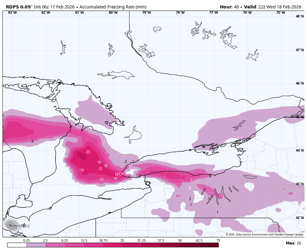
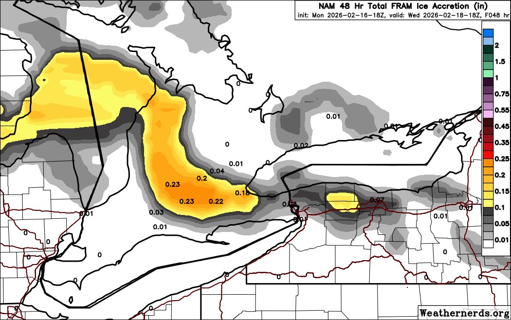
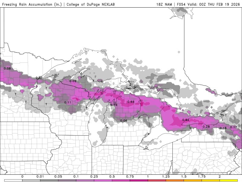
Biggest Concern with this storm will be the Ice Storm Potential 20-30+mm of ice accretion and 50-70+km/hr wind gusts would lead to widespread power outages We are still 3+ days out and things will change Hopefully, we see a downtrend in the coming days Will update #OnWX #ONStorm

English
6
5
43
8.7K
WeatherMan07
WeatherMan07@WeatherManRed1·
@stormwx1 I would be careful taking both accumulation and FRAM build-up right now. Accumulation may be a bit high along the lakeshore but FRAM output doesn't match the surface temperatures of the run either so they’re both conflicting each other. Still got 24-36 hours for this to correct.
English
0
0
3
215
Stormwx1
Stormwx1@stormwx1·
Careful with freezing rain maps with upcoming system Wed. For example, the NAM shows >0.6” of freezing rain falling in Toronto but the FRAM model shows 0” accreting; marginal temperatures & potential for mixing (plain rain or ice pellets) may limit icing especially near the lake.
Stormwx1 tweet mediaStormwx1 tweet media
English
4
2
39
7K
WeatherMan07
WeatherMan07@WeatherManRed1·
@stormwx1 Thankfully EC has acknowledged this. “An upgrade to blizzard warning may be required, but there is still some uncertainty on the strength of the winds and their duration.” For portions of the Blowing Snow Advisory SE of Huron.
English
0
0
1
41
Stormwx1
Stormwx1@stormwx1·
Some areas in the blowing snow advisories will likely see blizzard conditions at times especially E of Lake Huron. A blizzard warning would easily verify in some areas Fri PM into early Sat.
Stormwx1@stormwx1

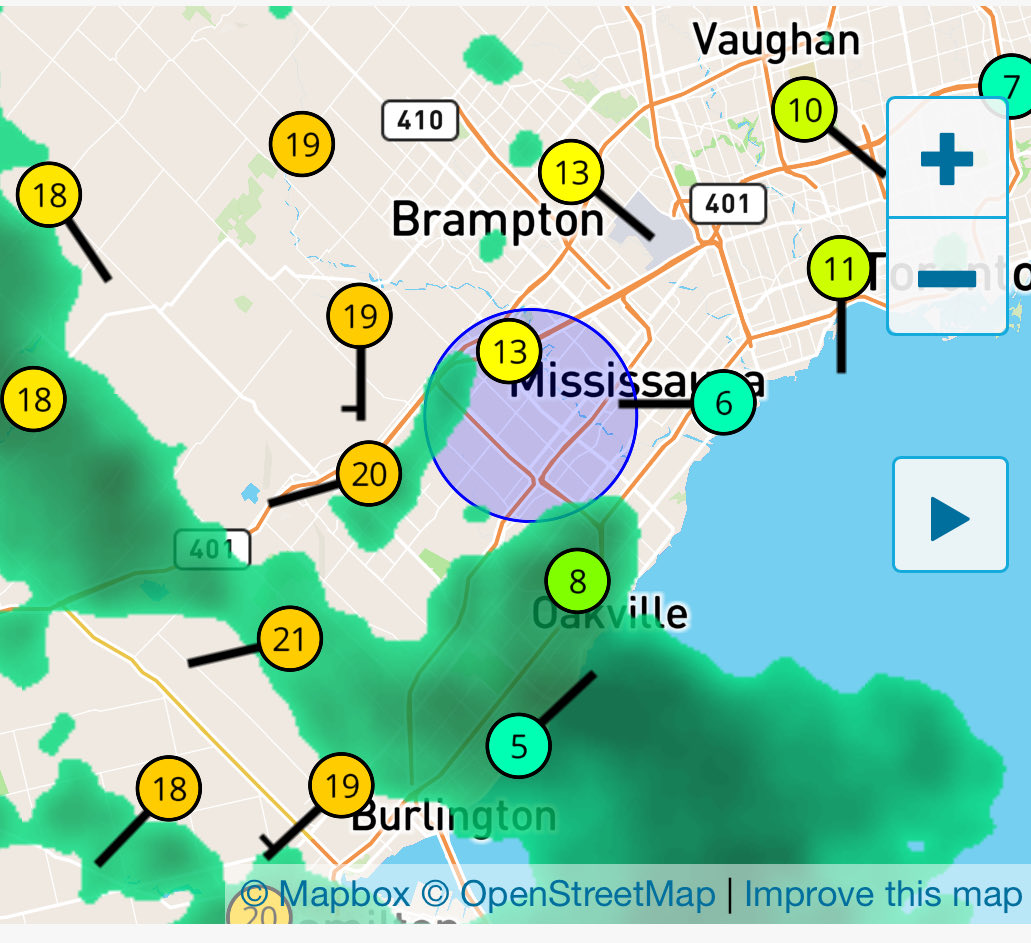
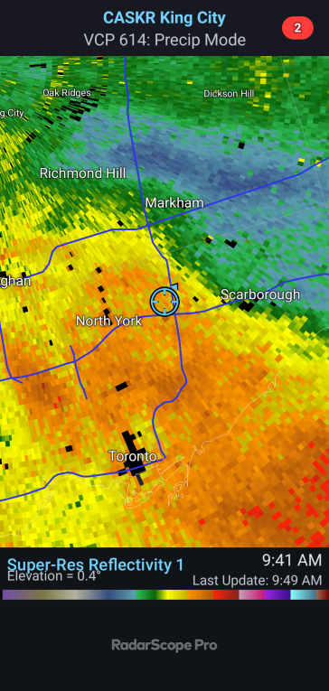
Special weather statements for the GTA for wind gusts up to 80km/h, 4-8cm of snow, and local blowing snow Fri and cold wind chills for Fri PM into Sat. Blowing snow advisories (yellow) for same thing outside of GTA but impacts much greater in open areas with near zero visibility.

English
1
0
10
1.7K
WeatherMan07
WeatherMan07@WeatherManRed1·
38cm of snow in multiple measurements as of 10pm in south Burlington. Prolific snowfall rates continued w/ likely 6-10cm/h. Estimating ~50cm without drifting as of snow as of 12am. Near zero visibility at times, with gusty winds. Squall is starting to sink south. #Onstorm
WeatherMan07 tweet media
English
0
1
2
641
WeatherMan07
WeatherMan07@WeatherManRed1·
@stormwx1 ALSO, OSPC always has different confidence levels on their maps than EC Mets put on the alerts. Yesterday GTA was high due to high confidence and high impact. Yet yellow watches and warnings went out. Today.. OSPC DOWNGRADES the confidence to moderate and it’s back at yellow..?
English
0
0
0
125
Stormwx1
Stormwx1@stormwx1·
Winter storm & snowfall warnings (yellow alert) now in effect for much of Golden Horseshoe. Would be shocked if we don’t see upgrades to orange level later today if current trends hold.
Stormwx1 tweet media
English
4
7
34
4.3K
WeatherMan07
WeatherMan07@WeatherManRed1·
@stormwx1 EC has really been pissing me off recently. 15-30cm with 50km/h winds and lake enhancement is a yellow WSW for Burlington but 15-25, 50km/h winds and lake enhancement in Hamilton is a yellow snowfall warning. Which should be a large difference between the two but.. 1/2
English
0
0
0
97