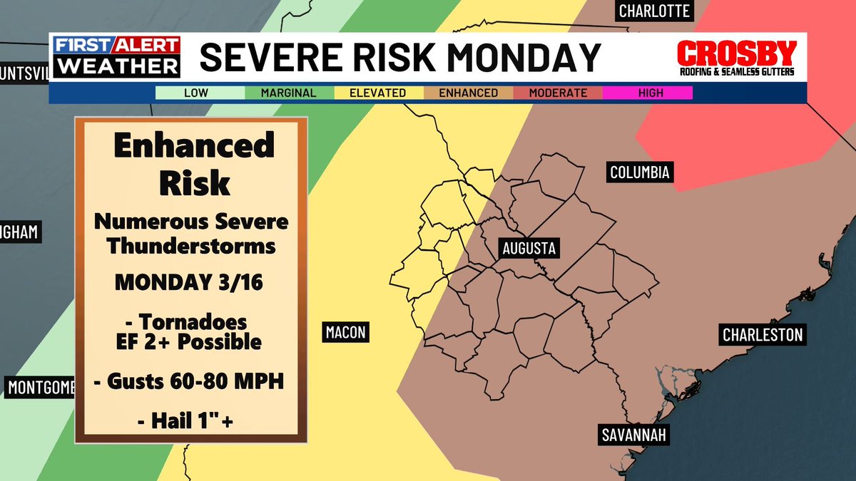
Mikel Hannah-Harding

2.2K posts

Mikel Hannah-Harding banner
Mikel Hannah-Harding

Mikel Hannah-Harding

@Weatherman_Kel

On Camera Meteorologist | @weatherchannel | AΦΑ 🤙🏾 | Alumnus 🎓 | @CofC 🐾 | Beaufort, SC ➡️ Charleston, SC ➡️ Augusta, GA ➡️ Atlanta, GA 📍

Katılım Haziran 2020
289 Takip Edilen536 Takipçiler
Sabitlenmiş Tweet
Mikel Hannah-Harding
Mikel Hannah-Harding@Weatherman_Kel·
I’m proud to formally announce that I am now an On Camera Meteorologist with The @weatherchannel working with the Allen Media Weather Hub in Atlanta, GA! So grateful for this opportunity to expand my network, grow as a meteorologist, and gain more exposure! 🙏🏾💙💯
Mikel Hannah-Harding tweet mediaMikel Hannah-Harding tweet mediaMikel Hannah-Harding tweet mediaMikel Hannah-Harding tweet media
English
1
0
10
1K
Mikel Hannah-Harding
Mikel Hannah-Harding@Weatherman_Kel·
Beautiful but breezy Round 1 today at Augusta National! Nice and dry conditions persist heading into cut day tomorrow and through the final rounds this weekend. I never saw a Masters forecast this quiet while I was in Augusta and this could be the driest one in over a decade! ⛳️
Mikel Hannah-Harding tweet media
English
0
0
0
90
Mikel Hannah-Harding
Mikel Hannah-Harding@Weatherman_Kel·
From Severe Thunderstorms this morning, to sleet/snow this afternoon in Atlanta! You can’t make this up!! 2026 has been a doozy weather wise already. Checkout my view @NWS @NWSAtlanta @weatherchannel ❄️
English
0
0
0
63
Mikel Hannah-Harding retweetledi
Riley Hale
Riley Hale@RileyWRDW·
Have a way to receive alerts early Monday through the afternoon for the threat of severe weather. The CSRA is under an enhanced risk (level 3/5) - a severe outlook we only see a couple times a year for our region. More here: wrdw.com/weather/
Riley Hale tweet media
English
0
2
8
246
Bill Walsh
Bill Walsh@BILLWALSHTV·
Sitting on a @Delta @DeltaNewsHub aircraft two hours past departure time at ATL completely full with no air conditioning or flt crew. I get wx and diverts but no comms from dispatch or FA’s. Hot as a sauna. Hope crew doesn’t time out.
English
4
0
16
2.8K
Mikel Hannah-Harding retweetledi
Jim Cantore
Jim Cantore@JimCantore·
Absolutely crushed in Atlanta metro yesterday evening and this mornings rain is just more misery.
English
10
12
156
21.2K
Mikel Hannah-Harding retweetledi
NWS Boston
NWS Boston@NWSBoston·
[Potentially Historic/Destructive Storm southeast of the BOS-PVD corridor] We are very concerned for areas southeast of the Boston-Providence corridor where wet snow combines with northeast wind gusts of 60-70 mph. Power outages & tree damage. Worst conditions Mon 4 am to noon.
NWS Boston tweet media
English
40
258
1.4K
513.8K
Mikel Hannah-Harding retweetledi
Jim Cantore
Jim Cantore@JimCantore·
It’s been years since I’ve seen this kind of blizzard warnings for the northeast. Too say it’s long overdue is an understatement.
Jim Cantore tweet media
English
135
352
2.7K
365.3K
Mikel Hannah-Harding retweetledi
Jim Cantore
Jim Cantore@JimCantore·
Starting this weekend as the eastern storm is winding down, the true pattern change for the west emerges with multiple systems targeting the entire west with rain and mountain snow throughout the week. It should also turn much much colder on the west coast. This represents the best snow potential over the intermountain west we have seen the entire season. We won't get back to normal SWE over the interior, but it will give a little life to an otherwise abysmal season. The Sierra should do extremely well with this set up as SWE has dropped extensively from early January due to the warmth and lack of snow. This should really be a great jolt for CA as we continue our 4th banner year for CA winter precipitation. @PivotalWeather @weatherbell
GIF
GIF
English
3
18
132
17.3K
Mikel Hannah-Harding retweetledi
Bill Walsh
Bill Walsh@BILLWALSHTV·
FIRST ALERT// Winter Weather Update // THURSDAY  WINTER STORM WATCHES ISSUED (Expect Colleton and Tricounty to be included this afternoon) Confidence is high that we will see some snow this weekend.  The question is how much which we will continue to fine tune with further model runs today and tomorrow.  The combination of a strong upper level low and developing coastal storm mixing with VERY cold Arctic air are the right ingredients for snow in the Lowcountry.   WHAT WE KNOW Very strong upper level low will dive into the Southeast and help develop a coastal storm at the surface.  The energy alone from this upper system will be a trigger for precipitation in addition to the system in the lower levels cranking up over the ocean.  Unlike last week with the freezing rain event, the depth of the cold air on this system is right to the surface therefore I expect all snow.  There may be some sleet mixing at the beginning of precipitation closer to the coast before turning to all snow.  WHAT WE DON’T KNOW How much!!  Given the 10:1 ratio and amount of moisture available, early guesses are 1-2” CHS south and 2-4” CHS west and 3-6” Georgetown to Kingstree and higher amounts towards Myrtle Beach and NC.  CAUTION that this is just looking at current model runs and there will be plenty of wiggle room given unknowns like dry air slots and banding possibilities. TIMING Saturday morning through early Sunday but there is wiggle room in this window depending on model runs.   WHAT TO DO Plan on at least some snow on roads and surfaces could be slippery.  Travel will not be impossible like an ice storm but could get sketchy depending on amounts.   ADDITIONAL CAUTIONS VERY cold Arctic air will settle in Sunday keeping anything on the ground frozen and refreezing on Monday night.  Wind chill values could be as low as 10.   GUSTY winds expected especially along the coast from 20-30 mph. We will keep you advised. @Live5News
Bill Walsh tweet mediaBill Walsh tweet mediaBill Walsh tweet mediaBill Walsh tweet media
English
0
3
25
2.1K
Mikel Hannah-Harding retweetledi
Jim Cantore
Jim Cantore@JimCantore·
It's not out of the realm of possibility that many of you in this "CRIPPLING" area see ICE ACCRETION over 1". In a storm like this, FREEZING RAIN of that magnitude is a disaster. This could be where some of the biggest impacts lie simply because of extended power loss with very cold air to follow the storm. This is not an exacta, but I wanted you to see where you need to plan for extended power outages from TX in LA,MS, TN over to GA, NC and SC... This is a huge ara of real estate. Expect more fine tuning over time.
Jim Cantore tweet media
English
167
486
3.1K
722.9K
Mikel Hannah-Harding retweetledi
NWS Charleston, SC
NWS Charleston, SC@NWSCharlestonSC·
It's still too early to provide details, but certainly worth keeping an eye out as things come into focus later this week. #winter #scwx #gawx
NWS Charleston, SC tweet media
English
0
16
63
9.4K
Mikel Hannah-Harding
Mikel Hannah-Harding@Weatherman_Kel·
The main front has arrived in the lowcountry of SC and GA sparking another round of showers/storms. Most storms are staying below severe limits likely due to pre-frontal rain and a lack of sunshine to provide extra instability. Rain chances move out this evening! #Rain #Storms
English
0
0
0
34
Mikel Hannah-Harding
Mikel Hannah-Harding@Weatherman_Kel·
There will be a low threat for severe storms for Southern SC/GA, Southeastern AL, and the FL panhandle. Main concerns are damaging winds with hail and an isolated tornado on the table as well. Stay weather aware! #Showers #Storms #Severe #Cold #Front
English
0
0
0
38
Mikel Hannah-Harding
Mikel Hannah-Harding@Weatherman_Kel·
Tracking widespread rain moving through the (CSRA) during the pre-dawn hours of your Saturday. Rain will continue to push towards the coast of SC and GA this morning with a second round of showers and storms likely this afternoon/evening as the main cold front pushes through!
English
1
0
0
41
Tom Niziol
Tom Niziol@TomNiziol·
Here we are down at the Buffalo waterfront. I can't believe the birds flying in these winds but maybe it's safer there than in the ground. Winds have to be gusting over 70 mph now!!
English
44
145
1.1K
86.8K
Mikel Hannah-Harding
Mikel Hannah-Harding@Weatherman_Kel·
Arctic Northwesterly winds today will be ushering in cold air across the southeast! Prepare for a hard freeze in a lot of locations by Tuesday morning! 🥶
Mikel Hannah-Harding tweet media
English
0
0
0
53
Mikel Hannah-Harding
Mikel Hannah-Harding@Weatherman_Kel·
The good news is that moving forward from the Winter Solstice today, we will be gaining daylight each day as we head towards the Summer Solstice! ☀️
Mikel Hannah-Harding tweet media
English
0
0
0
40
Mikel Hannah-Harding
Mikel Hannah-Harding@Weatherman_Kel·
Can’t let today pass without wishing the ICE COLD brothers of ALPHA PHI ALPHA FRATERNITY, INC. a Happy 119th Founders’ Day! Grateful for this brotherhood and how it has contributed to who I am today. To Manly Deeds, Scholarship, and Love For All Mankind. ‘06 TTGB! ❄️🤙🏾💯
Mikel Hannah-Harding tweet mediaMikel Hannah-Harding tweet mediaMikel Hannah-Harding tweet mediaMikel Hannah-Harding tweet media
English
1
0
0
49