

austin cooper
399 posts

this episode is the soft launch of a new show-
AI OPERATORS
so listen and get ready for the 19th operators spinoff!!!!
Operators@9operators
Will AI rival the industrial revolution? Is it already happening? Who’s going to win: DTC vs incumbents? @FoldesCraig (formerly Global Head of AI at Crocs) and @matthew_kruer (CIO, BISSELL) sat down with @Seanfrank (CEO, Ridge) to discuss: - How to rip 250 ads in 2 days - What executives should code - Why AI for the DTC “rebels” And most importantly, the best ways to grow your brand right now.
English

Existing Flexport customs brokerage customers are auto enrolled in our tariff refund process and we’ll begin filing protests for them well before the deadline.
Ryan Petersen@typesfast
We're enrolling companies be the first in line to process for tariff refunds start happening. 22 Fortune 500 Companies signed up to get into the process yesterday. We've made the process dead simple and free to enroll. When the window opens, we will be the fastest, most accurate, and most affordable way to get refunds in the world.
English
@typesfast Current customers need to enroll or are we already in line?
English
We're enrolling companies be the first in line to process for tariff refunds start happening.
22 Fortune 500 Companies signed up to get into the process yesterday.
We've made the process dead simple and free to enroll. When the window opens, we will be the fastest, most accurate, and most affordable way to get refunds in the world.
English
One cool thing about working in global logistics is that it’s 24/7 so you can just work all the time and there’s always someone somewhere in the world to work with.
English

Mountain residents im looking for current snow amounts so far, please share! #CAwx #BigBear #LakeArrowhead #Snow
English
@SoCalweathernet @jason61987 Hoping for snow in Pine Cove at 6200’ with this one
English
Plenty of cold air coming in on Christmas and snow levels for now have trended a bit lower, snow levels could be 6000ft by Christmas afternoon depending on timing details and the 2nd system may literally move in Christmas night with no break between the AR&Alaskan Low which may hang around through the weekend with snow levels possibly down to 4k by Friday-Saturday. But of course details will continue to change, hope the colder trebd continues for Christmas 🎄
English

On Friday, December 19, 2025, at 9:49 AM, A powerful storm originating from the Marshall Islands is expected to bring heavy rainfall and flooding throughout the state. Wind speeds could reach 60 to 80 miles per hour, with gusts potentially intensifying on Christmas Eve afternoon through late December 25, 2025. This evolving weather pattern has not been witnessed since December 2004, when temperatures reached 90° before these events were induced by the warming of the Pacific.
Residents in all areas affected by the previous burn scar zone Eaton and Pacific Palisades need to be prepared with sandbags and remain alert for potential thunderstorms that may surpass safety thresholds in the Eaton Fire Burn Scar Zone and Pacific Palisades Burn Scar Zone. This information is crucial, as the storm is rapidly approaching and is forecasted to be a highly impactful and severe system for the entire state during the holiday period.
I’m very concerned for the Bay Area which potentially could have tree snapping like twigs and powerlines could come down as early as December 23, 2025 also very concerned for Santa Barbara to Western Los Angeles counties as this potentially could cause power outages and lots of down trees are possible with wind gust up to 45 to 80 mph gusts are not out of the question.
More details are still emerging on this prolific storm that is coming our direction sometimes storms that don’t arrive right away tend to be stronger and delayed when they arrive later on and that’s exactly what this one is doing. This one was supposed to arrive December 3 through the 10th 2025 is now arriving right on Christmas time absolutely something the power of nature at its finest.
Unfortunately, snow levels will be above 7000 feet so many resorts will probably see a dusting however mostly above 8,000 feet still monitoring the snow levels with the system especially after December 26 through the 27th another impulse will come through little bit colder airmass behind it. The next 24 to 42 hours to be critical as we are now just days away from this event. #CAwx

English
Flexport Fulfillment’s Black Friday Cyber Monday week by the numbers:
2x order growth over last year while maintaining 99.7% on time delivery.
If your 3PL shat the bed this year call me.

English
@SupplyChainDive Boost your shrink number as well. Theft is a real problem.
English

BNSF Railway and CSX say their new intermodal schedules boost speed, flexibility and optionality for shippers moving freight across the U.S. buff.ly/WzZ14ev
English
More than 1 million shoppers received a Flexport-fulfilled delivery this weekend. Hope you like your new stuff!
English
Duties in the challenged orders (MX, CA, CN IEEPA-Fentanyl + IEEPA Reciprocal) would be refunded if the supreme court upholds the ruling
English
Most of Trump’s tariffs have just been ruled illegal by the appellate court.
Next stop is the Supreme Court. If the administration loses American importers will enjoy a customs duty refund jubilee of biblical proportions.
English
@realwxforecast Has rained all day in Idyllwild (Riverside county)
English

Followers – Quick Thursday PM Update:
Reports from my followers confirm off-and-on showers across San Diego County this afternoon, with the unorganized moisture plume drifting northeast. Keep in mind, much of what you see on radar is falling as virga (evaporating before reaching the ground), so the returns may look more impressive than what’s actually reaching the surface.
Radar view via @NWSSanDiego:
🔗 radar.weather.gov/station/KNKX/s…
As mentioned in last night’s post, #Juliette’s remaining energy should exit the #SoCal region later tonight. My overall discussion and forecast outlook remains unchanged from last night posts. You can view it below.
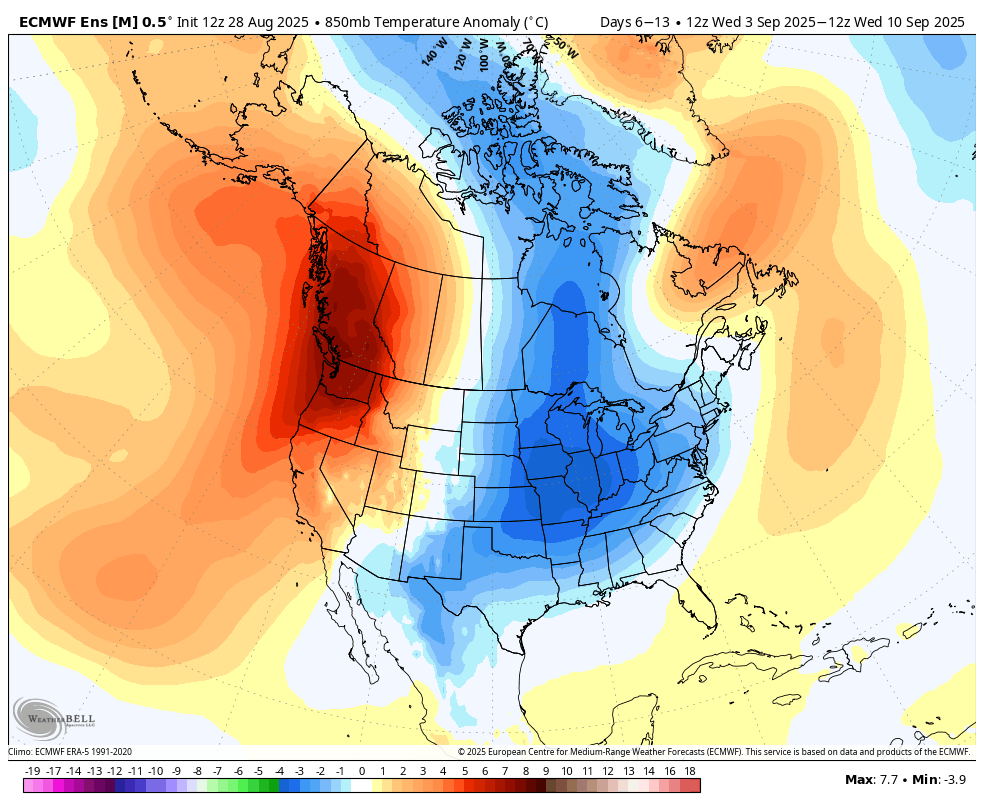
Long Range - Again, no huge heatwaves on the scope for the long range, but September looks to be above average out west, as the East Coast looks to transition fast from summer to fall. See below image. One thing for certain is the #PNW is getting the brunt of the heat for this time of you. Something to watch as we head into September.
More later......
#CAwx #California
J. Mesh, AMS 🇺🇸@realwxforecast
Followers - I have been flooded with DM's and messages tonight about Tropical Storm #Juliette, or what is left of her. Some people now thing she is similar to TS #Hilary, 2 years ago. Folks, I have imputed my data into my Gen AI program, and this spit out. It is pretty accurate. Folks, Orange County northward, will not any rain.....no rain folks. San Diego County might get light showers off and on. Read below and this tells you why: Here’s why Southern California and the Los Angeles area likely won’t get much rain from Tropical Storm Juliette—mainly due to weak upper-level dynamics and unfavorable structure of the system: 1. Exposure and Vertical Structure Juliette’s low-level circulation is now fully exposed, meaning the system’s convection has become stripped away by southwesterly shear. This indicates a weak tropical cyclone in terms of vertical integrity. (National Hurricane Center, Zoom Earth) The forecast indicates that Juliette will continue weakening, transitioning into a remnant low by late Thursday and dissipating thereafter. As it weakens, it becomes a more shallow system, with the low-level steering flow dominating the future track. In simplified terms: without strong deep convection and vertical alignment, tropical systems struggle to produce organized widespread rainfall, especially far from the original center. 2. Upper-Level Dynamics and Shear Persistent southwesterly shear is disrupting the storm’s vertical structure and limiting continued convective development. That shear further prevents upward motion and breaks up moisture–cloud organization. Additionally, the environment around the cyclone is described as dry in the mid- to upper-levels and stable, which again suppresses convective activity. These conditions—high shear, dry and stable mid-/upper-levels—are not conducive to heavy rainfall, especially for regions not very near the cyclone’s core. 3. Moisture Transport and Steering While some residual mid- to upper-level moisture associated with the decaying system could advect northeastward over northwestern Mexico into parts of the southwestern United States, this moisture plume will be elevated, and not guaranteed to produce surface-reaching precipitation. Depending on the day and steering flow, the remnant low and its moisture plume may or may not track far enough north, and the steering influences shift to low-level flow. So while moisture might be present, it’s not organized into strong vertical motion or broad coverage, limiting how widespread or heavy any precipitation would be. 4. Likelihood of Rain in Southern California / Los Angeles Given these structural and environmental factors: Convection is limited and sheared apart, with weak vertical organization. The upper-level environment is generally dry and stable, which is unfavorable for developing precipitation. Folks, when you look at your radars tomorrow, and think, oh, it is going to rain, it won't, it is virga!! Moisture transport may occur at mid- to upper-levels, but isn't guaranteed to reach the surface or produce rainfall. The system is forecast to weaken further and dissipate, reducing its potential impact window. Any rain (if it occurs) could be isolated, possibly confined closer to Baja or northwestern Mexico, with uncertainty for Los Angeles County. 5. Caveats and Uncertainty Forecast models vary—some bring limited rainfall near the Mexico border or nearby coastal zones, others keep things dry over Southern California. The uncertainty is high. The remnant moisture may produce higher humidity, and cloud cover, but not necessarily meaningful precipitation. There's some possibility of dry lightning or thunderstorms, especially if the moisture plume intersects with topographical or local instability, but this is not a given for Los Angeles County Rip currents and surf impacts are more certain, particularly along Southern California beaches, due to wave energy propagation offshore, even in the absence of rain. Summary Table: Factor Effect on Rain Potential in SoCal/LA Vertical Structure Weak, sheared—limits convective organization Mid/Upper Environment Dry and stable—suppresses precipitation Moisture Transport Possible mid-level moisture—but not guaranteed to produce surface rain Timing/Track Steering uncertain; system weakening and dissipating rapidly Forecast Certainty Low—some models show isolated showers, others show dry conditions Conclusion: Due to weak upper-level dynamics, high wind shear, a dry and stable environment, and a decaying shallow remnant system, Southern California and Los Angeles are unlikely to experience widespread or significant rainfall from Tropical Storm Juliette. Any precipitation that does occur would likely be isolated, light, or confined to southernmost coastal regions—not a substantial or even a rain event for Los Angeles. Folks, there you have it. I have modeled thru the Euro ENS and the Euro AI for the #SoCal rain fall numbers thru this weekend. Folks, they are meager, at best. Look at the images below. Baja might get some decent rain, but event San Diego County looks pretty scarce at best. Nothing north of SDC on any of the models. Might a rogue storm hit for a few minutes, maybe, but this ain't Hilary from a few years ago. There ya have it folks, this not in a big rain event, or anything. Moving onward, warm weather will return for the next 6-10 days, as you see below. I do think, #California, and #Socal will be above average temps for September, but I am not seeing any huge heatwaves in the long range scope. I do think the #pnw will get some very warm weather in the extended, so something to keep an eye on. The midwest, Northeast, and southeast, look to be done with summer, as much below temps have taken over from the oppressive heat that everyone, (including me) had experienced. Crazy weather patterns now, as the wave-lengths have completely flipped 180 degrees. Will keep you posted!! More tomorrow.... #cawx #tropicalstorm
English
More to come as the legal process unfolds. @flexport is tracking it as closely as anybody so we can help customers navigate the constantly shifting environment.
English
Yesterday the U.S. Court of International Trade struck down four major tariff orders imposed under the International Emergency Economic Powers Act (IEEPA).🧵
English

These numbers are crazy. There is no way around it; prices on everything are going up.
Ryan Petersen@typesfast
The Reciprocal Tariffs Have Been Announced: 🇨🇳34% on China 🇪🇺20% on EU 🇨🇭Switzerland 31% 🇻🇳Vietnam 46% 🇹🇼Taiwan 32% 🇯🇵Japan 24% 🇮🇳India 26% 🇰🇷Korea 25% 🇹🇭Thailand 36% 🇰🇭Cambodia 49% 🇬🇧Great Britain 10% 🇧🇩Bangladesh 37% 🇲🇾Malaysia 24% 🇿🇦South Africa 30% 🇵🇭Philippines 17% 🇮🇱Israel 17% 🇵🇰 Pakistan 29% 🇱🇰Sri Lanka 44% And a minimum baseline tariff of 10% on everybody else.
English
Big thing that jumps out is that he’s going hard on Asia and leaving Latin America at 10%.
If you’re setting up your supply chain that message should be obvious.
English
Long Beach port cruise was pretty cool. Highlight was definitely seeing North America’s only automated port terminal up close. Check out those self driving electric container movers! The group also liked seeing SpaceX’s recovery operation for Falcon 9’s caught by their drone ship.

English
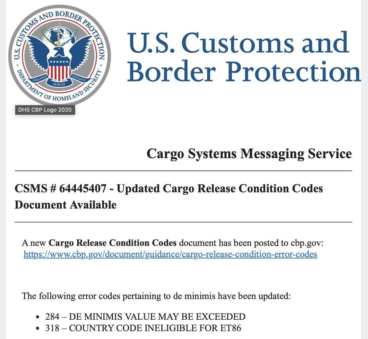
CBP has updated their error codes to include a new one for "country code ineligible for type 86 entries" -- de minimus, duty free entries for China and potentially other countries appears to be going away imminently.
English
@typesfast Business must be tough as I see they are pulling forward BFCM deals.
English
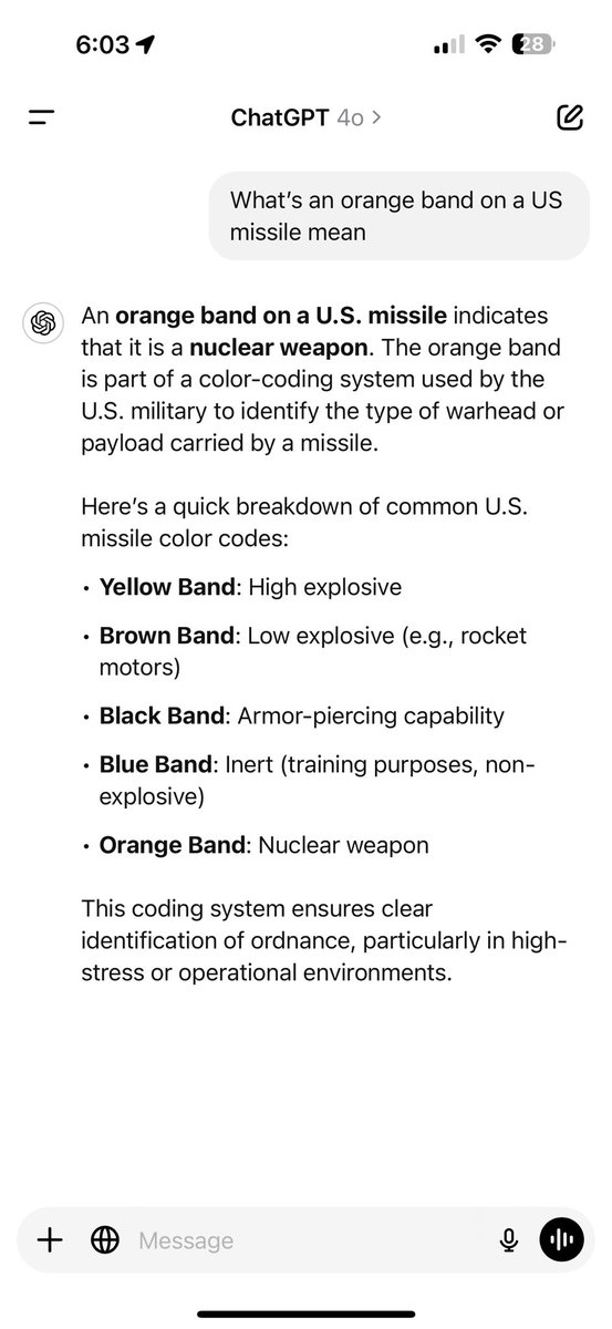
Someone is selling an AIM Sidewinder missile online the week the Pentagon failed an audit…

English