
Brent Sower
18 posts

@MidTnElectric @NashSevereWx It’s up to over 180,000 without power
English

⚠️9 a.m. Update⚠️
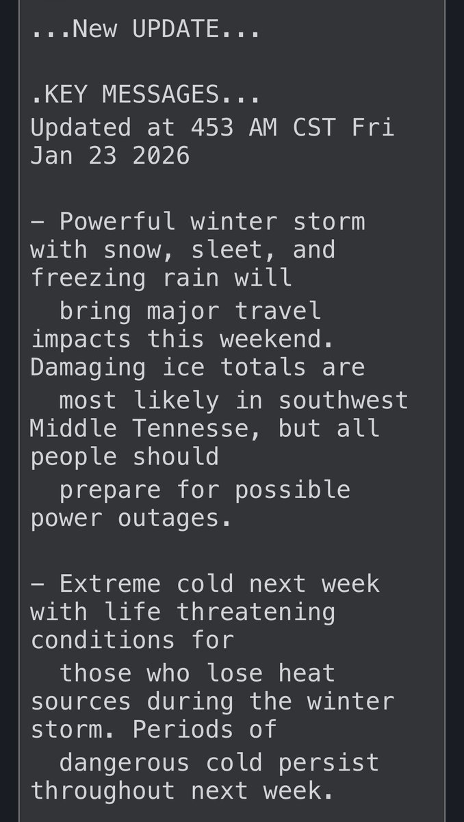
MTE currently has around 15,000 members without power. Given the severity of the situation and the damage to our system, please know this could be a long-duration event, with some repairs taking longer to fix. Rest assured that our crews are fully staffed and are working hard to restore power as soon as they can safely do so.
We do have poles down in Williamson County, which could increase restoration times. We are bringing additional crews into the Franklin area to assist with these repairs. We appreciate your patience and encourage everyone to stay off the roads due to dangerous conditions.
⚡If you see a downed line, assume it is live and stay at least 30 ft. away. Please call MTE at 877-777-9020 to report it or 911 if anyone is in immediate danger.
➡️ Due to high traffic on MTE.com, we suggest reporting outages via the myMTE app or by calling our automated outage number at 877-777-0215.


English
@NashSevereWx Is this also the model that I keep seeing other, less reliable Twitter folks post saying we’re going to get over an inch of freezing rain accumulation? That’s not right…is it?
English
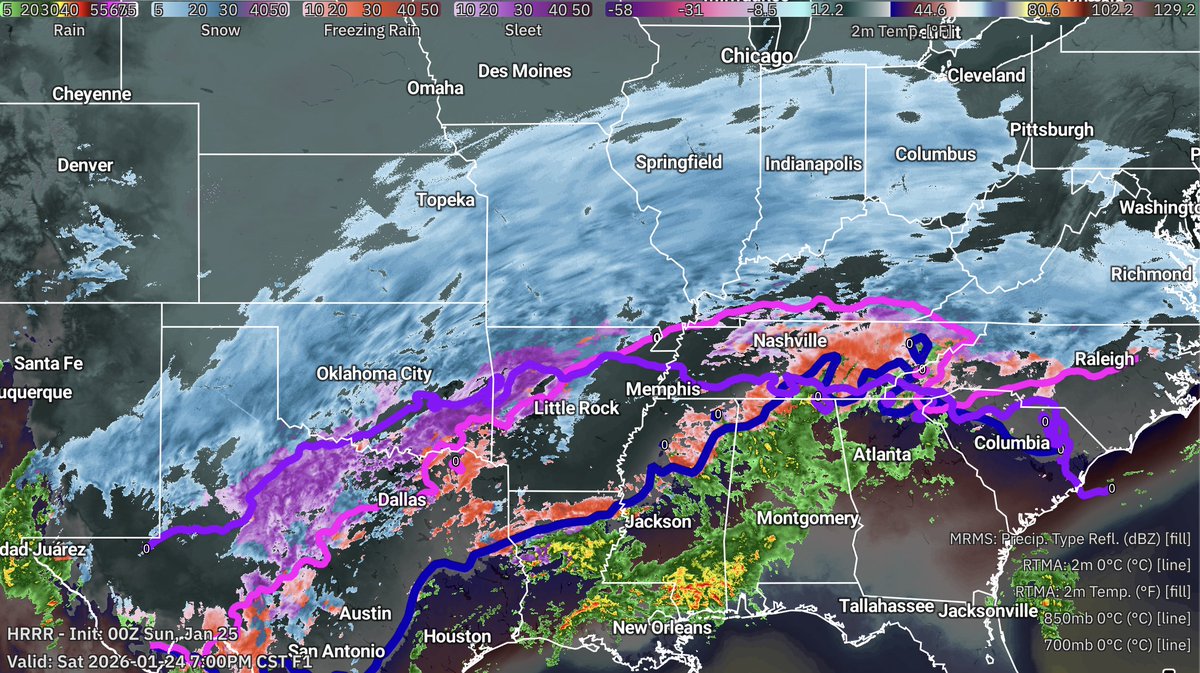
The latest HRRR model continues to show our "lull" filling in after midnight, and steady freezing rain falling from about 1am until noon tomorrow. This event is not over. The first round is. Second round yet to come.
GIF
English
@PettusWX I’ll keep my guard up…about something I can do nothing about.
English

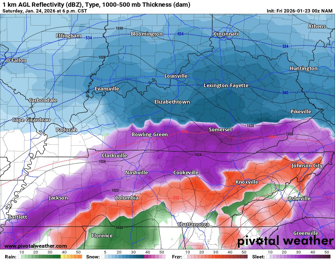
Getting a lot of comments about how this storm was a bust and that we have gotten no ice. That is because the bulk of the storm has yet to come. Not sure why we haven't seen ice storm warnings expanded, because people are letting there guard down. Do not let your guard down tonight.
English

@ZachVogt30 Per Painter he says he puts the guys in the floor that give the team the best chance to win, regardless of seniority. He is sticking with his MO. (Finally)
English

@NashSevereWx How likely is it that it’s freezing rain for 11 hours straight - and only freezing rain?
English
Latest HRRR believes liquid freezing rain will become more steady after midnight tonight and continue through the night and Sunday morning. Loop ends at 11am with freezing rain still falling. I I, for one, hope this is wrong.
GIF
English
@PettusWX Does that include sleet accumulation? It’s hard to believe an inch of freezing rain accumulation.
English


@DanielleBreezy @WKRN Which southern counties? Not much of anything coming down here despite radar showing we’re getting a ton of sleet.
English

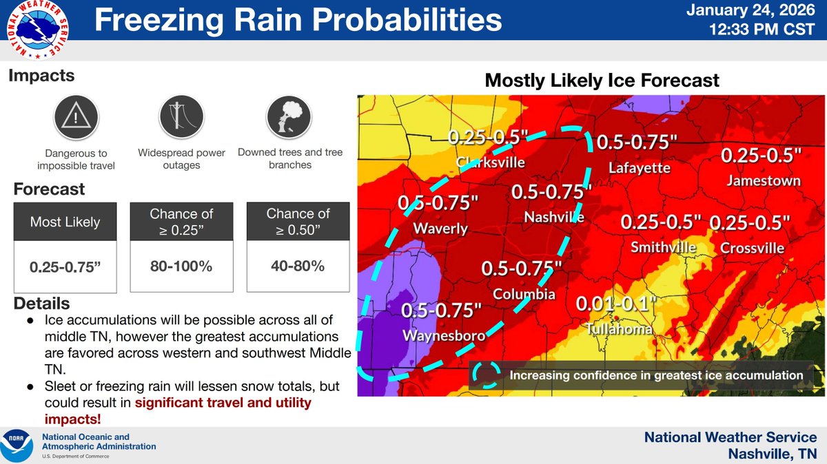
VERY CONCERNING PLEASE SHARE! Ice totals are growing as we are already seeing freezing rain in our southern counties! This will lead to severe impacts including making travel nearly impossible, downed trees, and power outages! Watch @wkrn now for the latest!

English
@NashSevereWx Well, that’s certainly not an improving forecast.
English
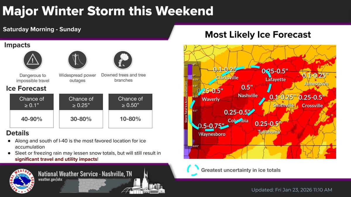
Latest forecast graphics continue to show highest snow totals the further NW you go. Biggest threat is freezing rain AND frigid temps. New NWS Nashville graphics hot off the press.

English
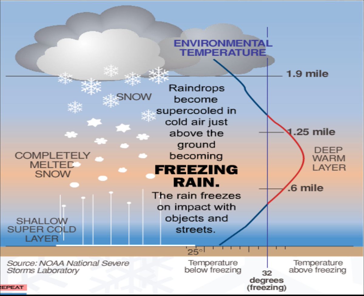
Refresher on what we call "Warm-Nose Ned." Surface temps below freezing. A mile or so up, temps warm above freezing causing snow to melt. How strong that warm-nose is (because it kinda looks like a nose on graphs) determines sleet or freezing rain. If it's weak, sleet. If it's more pronounced, stays liquid all the way to the ground...freezing rain. We call that warm-nose "Warm Nose Ned."
English
@Montcoseverewx Is that a bunch of just regular rain? How does that affect everything frozen that’s already fallen?
English

Here's the first Full High Resolution Look at this weekend's Winter Storm, per the 00z HRRR
Prepare for Winter Weather from ~07:00 AM Saturday morning through ~03:00 PM Sunday Afternoon
GIF
English
@Montcoseverewx When they make a forecast like this, is the .5" accumulation? Does it distinguish between sleet and freezing rain?
English
NWS Nashville has updated their guidance.

English
@Montcoseverewx I mean, it’s great to say be prepared. But unless you have a whole home generator, there’s no realistic way to “be prepared” for a 5-10 day power outage.
English
The Euro 12z makes it 10 runs in a row. Be advised of the potential here.
Montgomery County Severe WX@MontCoSevereWX
The Euro 06z is out. The last 9 runs of the Euro have consistently shown ~1.00” of Freezing Rain QPF. This is a significant concern, as it could result in ~0.40” - ~0.75” of accumuation. Wind gusts will be as high as ~30 MPH Sunday Night / Monday Morning The combination of these two would allow for numerous utility interruptions, excessive tree limb damage, and potential prolonged and widespread utility disruption with extensive damage to primary infrastructure. This is not a certainty. Nevertheless, prepare for the very real possibility of 5-10 day power outages.
English
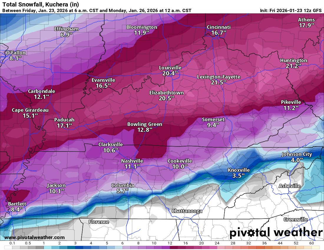
The 12z GFS has caved to the Euro, but still brings us a Strong Snow
English
@NashSevereWx How do you prepare for extended power outages when the temps are going to plunge to 0 and roads are impassible? Doesn't seem like there are a lot of great options if you don't own a generator.
English
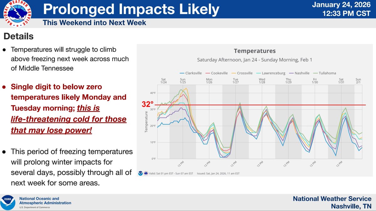
Bottom line? Forecast is on track. Prepare for power outages especially south of I40 where ice will likely form for a longer period of time. Impacts to roads will be significant as well. More details in the blog later.

English
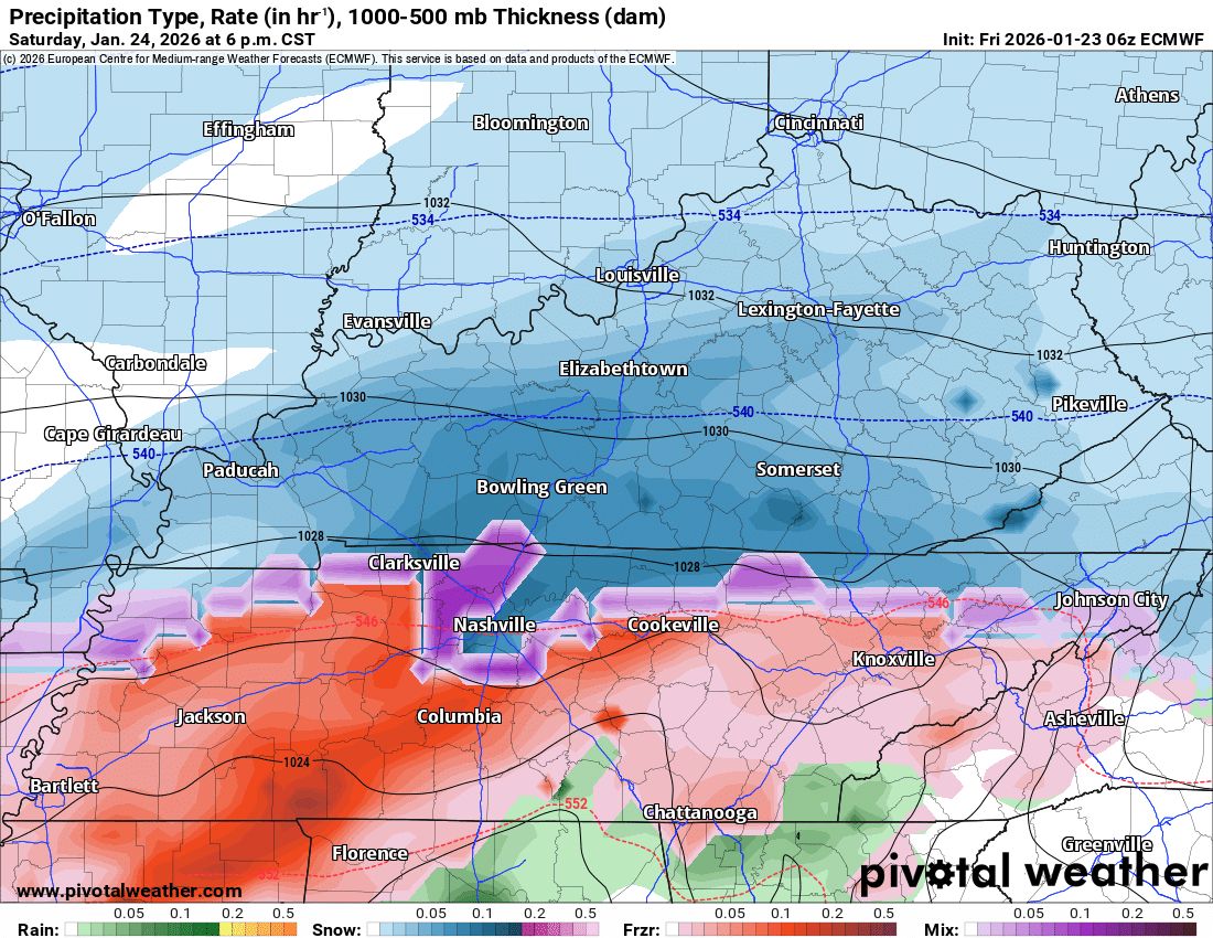
Short range CAMs are coming into view for Saturday into Sunday morning. Snow, freezing rain, sleet all possible. A wiggle north or south will change what kind of precipitation you see. The good news for our area is that we're trending somewhat back to a mostly snow solution north of I40 at least to start... Let's dive in.


English
First look at overnight data. Little has changed in our forecast. Snow then sleet then Freezing rain still most likely solution. Thread on model consensus by 830.
English
@NashSevereWx Easy to say, hard to do when a slight wiggle means your power and heat is potentially out for days.
English
Here's a great quote from NWS Nashville in their most recent area forecast discussion.
Embrace the uncertainty. Become one with the uncertainty..

English

If Tottenham can only sign one more player this month, realistically, who do you want? 💷
English
Nashville, TN is in a wild spot here
We’re either going to get a crippling ice storm, a remarkable sleet storm, or a whopper of a snow storm
And we got no clue which one we are going to get
English