Sabitlenmiş Tweet
cameron
5.7K posts

cameron
@brokenankle_
charlotte meteorology alum | my life + weather i guess
North Carolina, USA Katılım Ağustos 2015
462 Takip Edilen289 Takipçiler

English

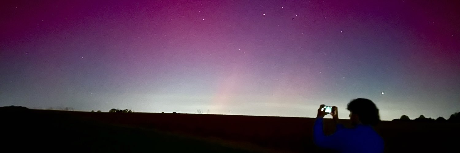
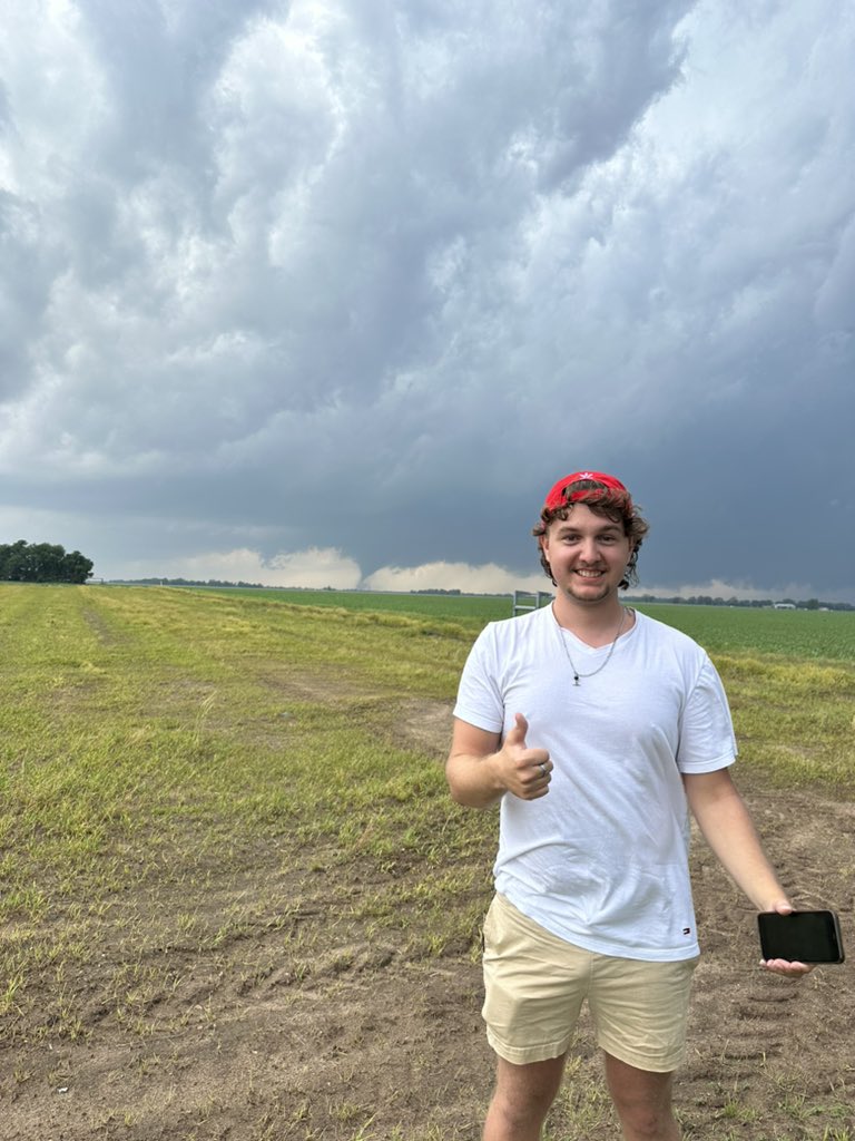
Throwback to the time I took a “shortcut” that was really a 40-mile controlled skid through rural western Kansas. No cell service. No turning back. Just WEEEEEEEEEE and prayers.
(And yes. I still did see a tornado that afternoon.)


English
cameron retweetledi

⛈️ I’m still tracking the risk of Severe Weather on Monday across NC. There have been some promising trends today regarding the severe weather risk, which may be a little lower. Did you know I’m on YouTube? Here’s my video for tonight #ncwx youtu.be/EuFsG3aWRIs?si…
YouTube


English
really do not like the look of this
Darin Deveau@darin_deveauWX
Absolutely astonishing forecast box sounding from the NAM in NC on Monday. Hard to stress just how rare of a look this is for the area.
English
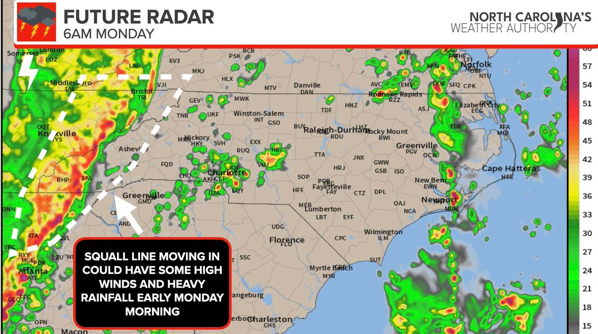
and storm motions will be 50-60mph, if you’re not used to chasing on tree covered highways be extra vigilant. 95 is under construction in the risk zone and other interstates/highways (40, 540, 98, US1, 64, 401) in central NC will be heavily traveled as the work day ends. #ncwx
Ethan Clark wx@EthanClarkWX
Storm chasers coming to the Carolinas to storm chase tomorrow. If you’re not used to our neck of the woods. Be prepared for tons of trees, not straight roads. It's not like the plains; it’s hard to see stuff here. #ncwx
English
cameron retweetledi

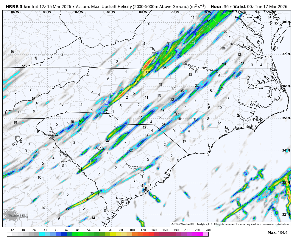
Hi-res models continue to paint a concerning picture for the NC Piedmont tomorrow.
Possibly numerous supercell storms with damaging winds and strong tornado potential quickly racing across the state.
Some folks could be in for a rough day. Please take these threats seriously.
English
cameron retweetledi

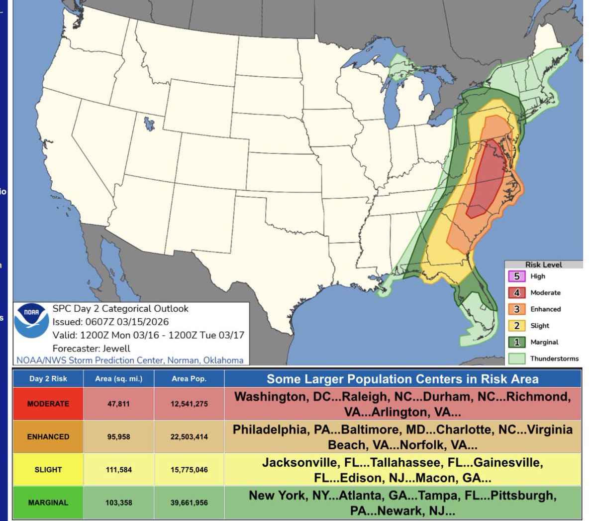
12:32pm CDT #SPC Day2 Outlook Moderate Risk: in parts of South Carolina, North Carolina, Virginia, Maryland, and Washington D.C spc.noaa.gov/products/outlo…

English
cameron retweetledi
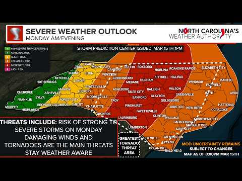
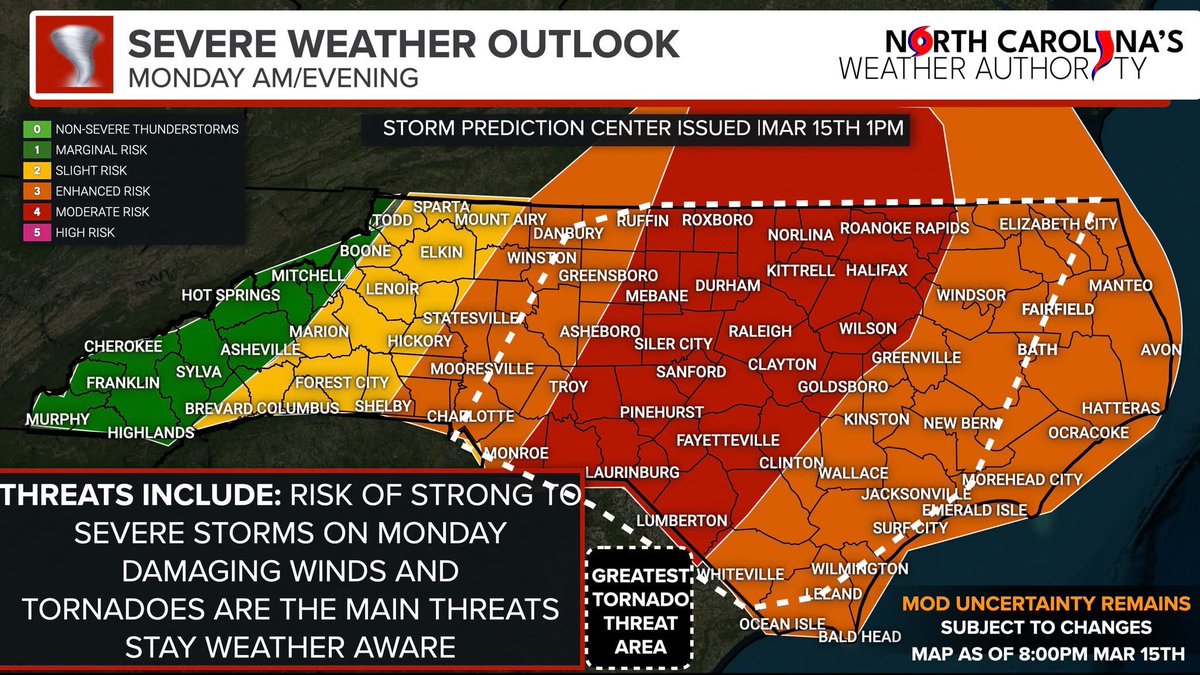
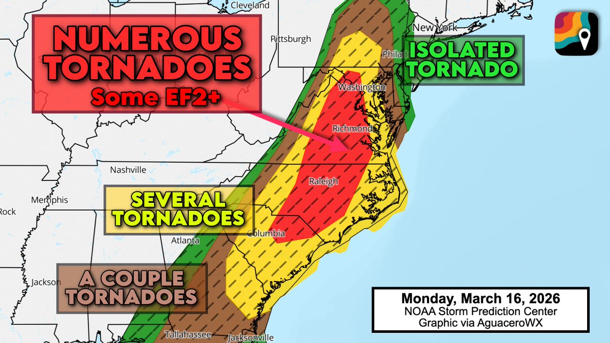
MONDAY, March 16 looks to be a real-deal severe weather outbreak with the risk of tornadoes, including perhaps a few significant (EF2+) and/or long-track in the Mid-Atlantic. Widespread damaging/destructive straight-line winds are likely too.
The Storm Prediction Center's forecast, issued Sunday, certainly hints at the possibility of a memorable event.
Our "parameter space" will be exceptional; a juiced-up atmosphere with moderate to extreme shear (spin)... and the likelihood of several rotating supercell thunderstorms to take advantage, especially in southern Virginia and North Carolina. I'm really watching the Richmond to Raleigh to Virginia Beach corridor as having the greatest threat of long-track supercells.
Then we ALSO have a destructive squall line coming in in the afternoon with 60-75 mph straight-line winds and embedded kinks of spin that could also produce quick-hitting tornadoes.
School districts should spend Sunday reviewing their severe weather plan, communicating with parents and/or adjusting activities and schedules as needed.
English
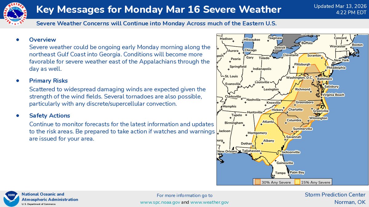
all hazards are on the table for central north carolina tomorrow, so have a plan in place should a derecho (or localized damaging wind) or significant tornado impact your area. this has the potential to be an upper echelon event and you need to be prepared. #ncwx
NWS Raleigh@NWSRaleigh
🚨Moderate Risk (level 4) for Severe Storms Mon (3/16) What to Expect: 🌪️ Tornadoes: A few significant (up to EF2) possible 💨 Wind: Widespread 75+ mph damaging gusts ⏰ Timing: Monday afternoon/evening for line storms 👉Prepare now. Have multiple ways to get warnings! #NCwx
English
with model suites supporting slower frontal passage and further atmospheric destabilization along with a stronger surface low (on top of robust dynamic support) i would not be surprised if the ceiling (EF2+ tors, widespread damaging wind) is realized in NC/SC/VA. #ncwx

English
cameron retweetledi
A significant storm system is expected to bring widespread damaging winds and some embedded tornadoes from the Appalachians and Midwest to the East Coast Sunday afternoon through Monday afternoon.
English
cameron retweetledi

cameron retweetledi

cameron retweetledi

cameron retweetledi
PSA: on Thursday night, meteorologists at the National Weather Service in Norman, Oklahoma received phone calls and countless spam tweets… right as they were in the midst of severe weather operations.
Please do not call forecasters to let them know what you see on radar. They have access to ample data AND are better-trained to interpret data. In virtually every case, public tweets and radar screenshots address redundant aberrations, often incorrectly, that forecasters have already seen. It’s a distraction for meteorologists at the Weather Service tasked with issuing warnings.
Unless folks are familiar with side-lobe contamination, ice crystal canting, depolarization streaks, three-body scatter spikes, bounded weak echo regions, aliasing, bistatic coupling, attenuation, superrefraction, chaff, brightbanding, sun spikes, etc., then it’s likely that they don’t have a sufficient background to spot something that NWS haven’t already seen. That’s not to say that NWS is infallible — they aren’t. But know that there is ALWAYS someone in the seat watching radar… save for extreme examples, there’s probably nothing a hobbyist at home has seen that NWS didn’t already see, analyze, interpret and act on.
During severe weather operations, forecasters should be able to “lock in” without being spammed by screenshots.
English
cameron retweetledi

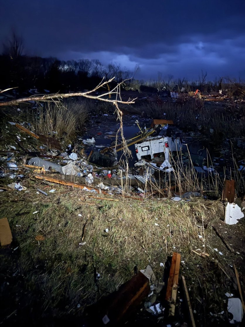
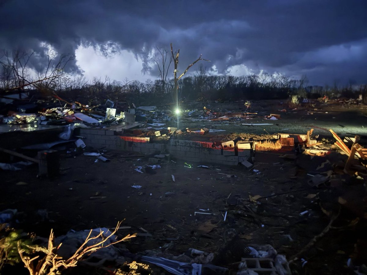
Please pray…multiple fatalities
We had a massive turnout of Samaritans helping everyone out as a community. It’s never easy to see this kind of destruction, but we dropped the chase and were able to help several people in the wreckage
Michigan strong ❤️
📍Union city, MI

English
horrible situation, praying for the people in three rivers. it looks like a tornado may have gone straight through the city
Hunte☈ Fowkes@StrmchsrHunterF
Tornado entering Three Rivers, MI.
English