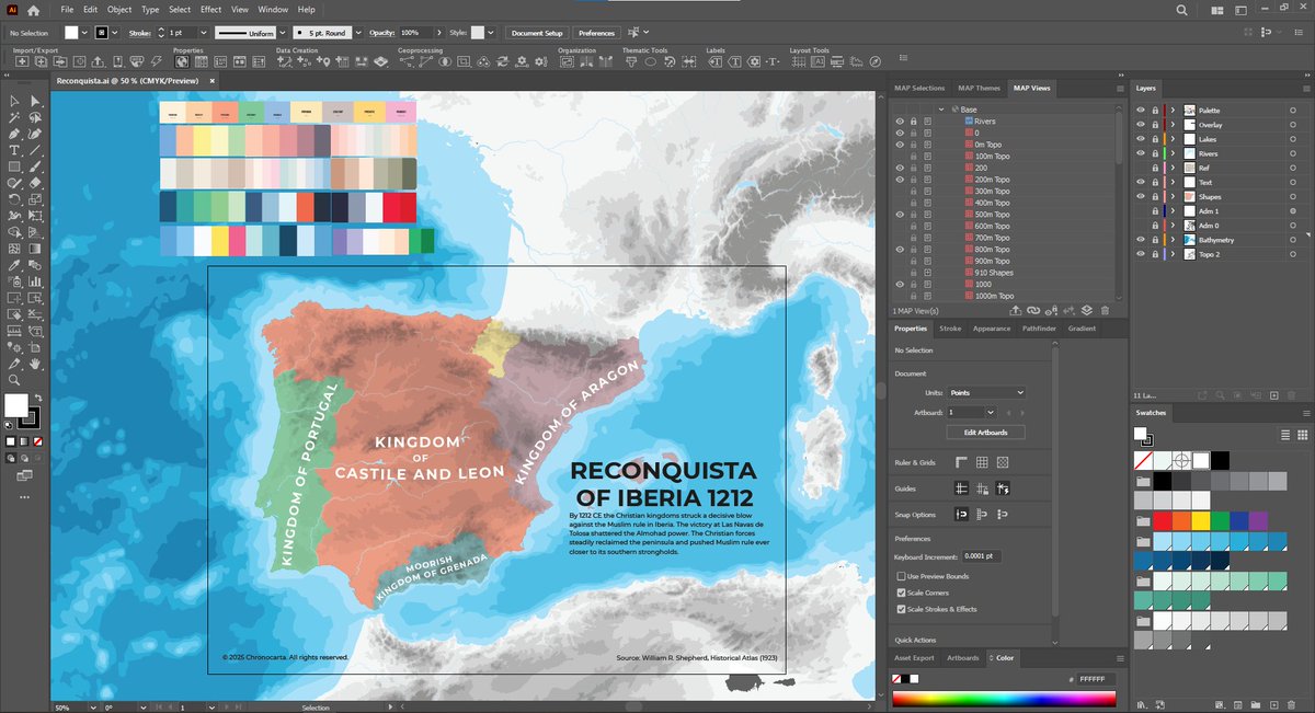
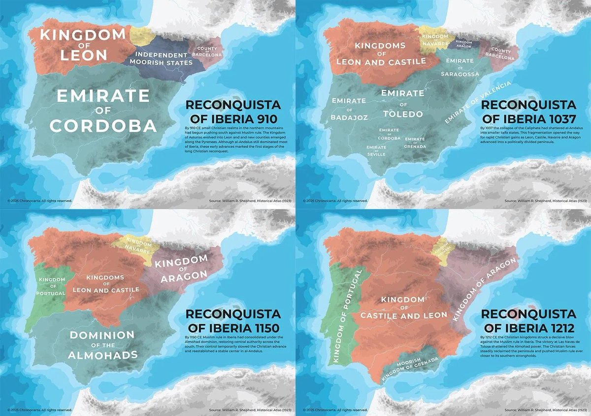
Chronocarta
417 posts

Chronocarta
@chronocarta
Visual history and cartography: maps of empires, migrations, and the world’s changing borders. 👇 Find more on Substack
Katılım Temmuz 2025
146 Takip Edilen2.2K Takipçiler
Sabitlenmiş Tweet

I wrote more in detail here:
open.substack.com/pub/chronocart…
English

@Finchedemo I've had a couple of people ask for tutorials before. I haven't seriously thought about it yet.
What specifically would you be interested in?
What format? Videos or text with images?
English

@chronocarta If available ,writing some tutorials would be better😏
English

@kvali_app I already am. All my new maps have GIS and georeference data.
English

If you want to explore more maps and history in one place, I have a newsletter here:
chronocarta.substack.com
English

@Buckeruu @treblewoe I use Common Era as a cultural, academic and practical term that's commonly agreed upon, not a theological one.
I don't center my worldview around any religions.
Also, the birth of Jesus is possibly miscalculated and happened between 6 BCE and 4 BCE.
English

@chronocarta @treblewoe Why do you use CE and not AD? What about the Era is Common? Who made the Calendar you use?
You don’t have to disrespect Christian civilization in accordance to your practice of history.
English

@EditorEnBici The historical maps I've shared so far, I made in Illustrator.
But I've been working on a map app for a while to make and share them in an interactive format. So that people can actually engage with them.
English

@verlagmeyer I don't know what advice to give here, because I don't know where you're at now. Learning to code may be the first step.
English

@chronocarta Illustrator I can use. How do you get started on DeckGL ?
English

@SoarAtlas So right now geo referencing works by manually setting points.
But this will use AI to do it automatically?
English

This is BIG! 🚀
We've made an AI tool that automatically georeferences maps. It analyses coordinates, text, and shapes in your image to cleverly place it over its location.
The results are shockingly accurate!
Join the waitlist to be notified: georeferencer.ai
English

@youwillmakemaps MAPublisher is pretty awesome.
The only complaint that I have is that with big data sets, it gets really slow.
But that's an Illustrator issue. Even without MAPublisher.
English

Eating crow with this tourist map project: styling "drag a box, get an SVG" non-georeferenced vectors is a fast way to map, but if the client wants a new extent ("show more to the east") you have to start with a new raw SVG instead of adding data to your current view.
So I restarted in a geo-aware way using MAPublisher. An ounce of prevention...
1) Added U.S. Census Bureau TIGER/LINE coastline and roads, put them under my extant road lines and deleted what I didn't need (always tedious, can't be skipped when making maps for humans). Select-by-location was too annoying to get working since the original roads I wanted to extend were not georeferenced
2) Overlayed a bus route (thanks Cursor + Claude for reading "GTFS API" documentation, whatever that is) and conformed it to my road layer
3) Adjusted the labels to match the new zoomed-out scale, wiped some and added others
4) Moved the inset. Let's see if these changes stick....
Evan Applegate@youwillmakemaps
The simple brochure-style maps I often make for clients don't require a cartographer; anyone sorta good at Illustrator/Inkscape can do these 1) Drop pins in Google Maps 2) Export a KML 3) Pick a map area via @mapcreator_io 4) Export an SVG 5) Delete cruft in Illustrator, style
English

@_vinayak_k I'm not opposed to it, but:
It's React & Next.js, not Vue
Still very early in development
Not optimized, the data alone is 116mb
I'm using sketchy tricks to get things look right. Like polygons for arrows and text.
English

@chronocarta i’d love to add this to my examples i’m working on - mapcn-vue.geoql.in/examples
English

@theepicmap I don't mind people sharing my maps.
But please link back to my profile.
English

@rodnoverkind @theepicmap I used The Goths by Peter Heather as my main source.
English

@theepicmap Please epic maps i need this, my ostrogoth grave goods sources are kinda homeless
English

@SputniksWorld @theepicmap Thanks! You may like some of my other maps too. Check out my profile.
English

@theepicmap That is one of the most interesting maps I’ve seen💯
English

Making a new map is always a hit or miss.
🧵Here are some of my most popular ones. Starting with my first and most popular one.
Let me know what other eras, areas or topics you want to see more maps of.
x.com/chronocarta/st…
Chronocarta@chronocarta
According to the monk Bede (731), the Anglo-Saxon story began when 3 ships of war landed in Britain. Invited by local rulers. Their success and the cowardice of the locals invited others. Soon, they crossed the sea, settled and conquered. A neat tale, written 300 years later.
English


