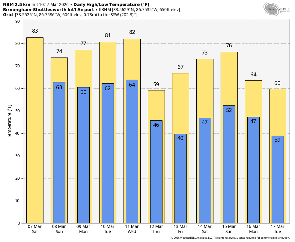
Rex de Foor
55.3K posts

Rex de Foor
@frexd4
An ATP pilot looking for an opportunity. Retired from AT&T.
New Iberia, LA Katılım Haziran 2011
751 Takip Edilen733 Takipçiler
Rex de Foor retweetledi

Get ready for a warm weekend ahead with highs in the 80s, and showers will remain hard to find across Alabama through next week. Forecast details are on today's morning briefing: youtube.com/live/6tWYBx3I8…

YouTube
English
Rex de Foor retweetledi

Following Jesus shapes not only the big decisions in our lives, but also the everyday moments—our conversations, our work, our relationships, and the way we use our time. Each part of our lives becomes an opportunity to reflect God’s goodness and bring Him glory.
Is there an area of your life where God might be inviting you to refocus your heart on honoring Him?

English
Rex de Foor retweetledi

No matter what you have done, you can be forgiven—if you turn to Jesus. #Devotional
intouch.org/read/daily-dev…

English
Rex de Foor retweetledi

ON THIS DATE IN 2018: Six tornadoes and hail up to 5 inches in diameter affected the north half of Alabama.
An EF-3 tornado moved through Jacksonville, producing major damage on the campus of Jacksonville State University. It was on the ground for 34 miles, with estimated winds peaking at 150 mph. Four people were injured; there were no fatalities. An EF-2 tornado moved from near Ashville to Southside.
Grapefruit sized hail fell on Cullman. One of the largest hailstones found was by Craig Mann; a laser scan analysis revealed the hailstone measured 5.38 inches in peak width, weighed 9.8 ounces, and had a circumference of 13.75 inches. This is the largest hailstone on record for Alabama.


English
Rex de Foor retweetledi

HIGH IMPACT SEVERE WEATHER THREAT TONIGHT: A dynamic weather system with strong wind fields will push a line of severe thunderstorms through Alabama late tonight into the pre-dawn hours tomorrow.
SPC maintains a level 3/5 "enhanced risk" for much of North and West Alabama, and they have introduced a level 3/5 risk for Southeast Alabama as well.
Here are the key messages...
*The line of storms will enter the northwest corner of the state around 9-10 p.m... and will move out of the southeast corner around 6-7 a.m. tomorrow.
*Damaging winds are likely along the line. In some cases wind gusts could exceed 70 mph. Expect significant, potentially widespread power outages.
*A few isolated tornadoes are possible within the line. After 3:00 a.m... high resolution models suggest supercell storms will form across Southeast Alabama with a much higher tornado potential. A strong tornado or two (EF-2 or higher) will be possible from 3-6 a.m.
*Tonight most likely I will advise you to treat a severe thunderstorm like a tornado warning. Be in a position to hear warnings, and have a plan. Helmets for everyone; if a tree comes crashing down through your house, this could save your life.
*I would not want to be in a mobile home when this line comes through. Know the location of the nearest shelter and how to get there quickly. Have transportation arranged.
*Much colder air will follow the storms, and snow flurries/snow showers are likely over the northern half of the state tomorrow. Temperatures will be in the mid to upper 30s and we expect no impact.
*A freeze is likely pretty much statewide Tuesday morning with lows mostly in the 20s. Another freeze is likely early Wednesday morning over the northern half of the state.
*Get the Alabama Weather Network app on your TV, phone, and tablet so you can watch our live coverage tonight; we have the entire state covered with a large team of meteorologists in the studio and in the field with dash cams and drones. Follow AWN on YouTube; you can watch there as well on their channel.
Stay tuned for updates throughout the day.


English
Rex de Foor retweetledi

Rain moves out of Alabama later this morning; much cooler air is moving in. North Alabama will see some scattered light frost early tomorrow... forecast details are on today's morning briefing: youtube.com/live/YBn9szhgR…

YouTube
English
Rex de Foor retweetledi

Rex de Foor retweetledi

THIS AFTERNOON/TONIGHT: Thunderstorms will likely develop across Alabama this afternoon and tonight; some of those storms could be strong to severe. The main concern is large hail with steep lapse rates in place, but there is a low end tornado threat as well. 
The main window for severe storms will come from roughly 3pm until midnight.
Be sure and have the Alabama Weather Network app on your TV, phone, and tablet!


English
Rex de Foor retweetledi

AWN: If you are not doing it now, please take a minute and follow the Alabama Weather Network on social platforms, and have the AWN app installed on your TV, phone, and tablet.
While Alabama's tornado season runs from November through May, two of the most active months are March and April.
I have been doing weather professionally for 47 years, and I have never had so many resources. A large team of experienced meteorologists, dozens and dozens of high resolution cameras, a team of responsible chasers and drone operators in the field. AWN coverage is second to none, and it is visually interesting.
AWN provides long form coverage for all 67 Alabama counties. It doesn't matter which National Weather Service provides warnings, or your TV market. It doesn't matter if your county is one of the least populated in the state, or if big cities are there. The coverage is the same for everyone.
It is also important to note we don't use scare tactics on routine weather days. When the weather is truly dangerous. and life threatening, we will use very bold language when needed.

English
Rex de Foor retweetledi

SHOWERS/STORMS ARRIVE LATE TODAY: Most of today will be warm and dry for Alabama; temperature rise into the low to mid 80s again, very close to record levels.
An organized batch of rain and thunderstorms will move into the northwest corner of the state around 3-4 p.m... it will move southward tonight.
SPC maintains a low end "marginal risk" (level 1/5) of severe thunderstorms for most of Alabama; a few of the storms late this afternoon and early tonight could produce strong gusty winds and small hail. Storms will weaken tonight after sunset.
Tomorrow will feature intervals of sunshine; best chance of rain will be over the southern counties of the state, but a few isolated showers are possible across North Alabama as well. Highs tomorrow will be mostly in the 70s.
THE WEEK AHEAD: While a few isolated showers are possible, most of Monday and Tuesday will be dry. An organized band of showers and storms will roll into Alabama Wednesday night ahead of a cold front. SPC has the northwest part of the state in a severe weather risk; we will have a much better idea of the overall severe weather threat in a day or two.
Much cooler air follows the storms, parts of North Alabama could hold in the 50s Thursday, and 30s are possible over the northern counties by daybreak Friday.


English
Rex de Foor retweetledi

The world will try to define you in many ways. By your past, by your circumstances, by your situations, by the world’s own brokenness.
But God defines you as His. You are His child. You are loved by Him, so much more than you could ever know.
“𝘚𝘦𝘦 𝘸𝘩𝘢𝘵 𝘨𝘳𝘦𝘢𝘵 𝘭𝘰𝘷𝘦 𝘵𝘩𝘦 𝘍𝘢𝘵𝘩𝘦𝘳 𝘩𝘢𝘴 𝘭𝘢𝘷𝘪𝘴𝘩𝘦𝘥 𝘰𝘯 𝘶𝘴, 𝘵𝘩𝘢𝘵 𝘸𝘦 𝘴𝘩𝘰𝘶𝘭𝘥 𝘣𝘦 𝘤𝘢𝘭𝘭𝘦𝘥 𝘤𝘩𝘪𝘭𝘥𝘳𝘦𝘯 𝘰𝘧 𝘎𝘰𝘥! 𝘈𝘯𝘥 𝘵𝘩𝘢𝘵 𝘪𝘴 𝘸𝘩𝘢𝘵 𝘸𝘦 𝘢𝘳𝘦! 𝘛𝘩𝘦 𝘳𝘦𝘢𝘴𝘰𝘯 𝘵𝘩𝘦 𝘸𝘰𝘳𝘭𝘥 𝘥𝘰𝘦𝘴 𝘯𝘰𝘵 𝘬𝘯𝘰𝘸 𝘶𝘴 𝘪𝘴 𝘵𝘩𝘢𝘵 𝘪𝘵 𝘥𝘪𝘥 𝘯𝘰𝘵 𝘬𝘯𝘰𝘸 𝘩𝘪𝘮.” — 1 John 3:1 NIV
Save 1 John 3:1 in the Bible App today, and remember how God defines you.

English
Rex de Foor retweetledi

Jesus never knew the fruits of sin—until he became sin for us. And when he did, all the emotions of sin tumbled in on him. Can’t you hear the emotion in his prayer at the Cross? “My God, my God, why have you rejected me?” (Matthew 27:46). maxlucado.com/listen/the-bri…
English


