GeoConfirmed

31.8K posts

GeoConfirmed banner
GeoConfirmed

GeoConfirmed

@GeoConfirmed

Map and Investigations = https://t.co/B93nqcHOaM Managed by volunteers.

Katılım Mart 2022
267 Takip Edilen227.7K Takipçiler
Sabitlenmiş Tweet
GeoConfirmed
GeoConfirmed@GeoConfirmed·
The State of the "X" OSINT Community, a message to the 'OSINT' accounts. Let’s all take a step back and look at the broader “OSINT” community, especially after Elon Musk’s changes. What do we actually see? Engagement Farmers. The majority of these accounts claim to do OSINT and even include it in their name. But most of them don’t do the work. At best, they’re bad news aggregators — copying and pasting information without citing sources, rewriting descriptions to grab attention, and shaping opinions based on unverified data. They chase attention, not accuracy. In other words, they’re engagement farmers. These accounts make up most of what’s now labeled as “OSINT.” News aggregators. Then there’s a second group — the news aggregators who at least add some value. They collect and organize information into threads or perform basic analyses that make data easier to understand. Importantly, they also give proper credit to the original sources. For them, it’s not about being the first to post — it’s about gathering reliable information and presenting it clearly and responsibly. OSINT. Finally, there are the 'real' OSINT accounts. A definition: "OSINT is the practice of collecting, analyzing, and interpreting publicly available information from open sources to produce insights for decision-making, threat assessment, and investigations." The real OSINT accounts go beyond aggregation. They verify locations, identify equipment types, and perform full investigations — turning raw data into actionable, verified insights. Mistakes. And yes, even OSINT accounts make mistakes. Why? Because OSINT is only as accurate as the information available at the time of analysis. That’s why verifying the basic data used in any analysis must always be a priority. Crediting sources is equally important — it allows others to understand the reasoning behind the analysis and, if necessary, to verify the same sources independently. When new information emerges, earlier conclusions may turn out to be flawed. It’s then the responsibility of the OSINT account to evaluate whether the new data impacts the final assessment. If it does, the correct course of action is clear: delete the original post and start again. Deletion is the only acceptable response when an error alters the conclusion. GeoConfirmed. We know where we stand: GeoConfirmed is a verification community of more than 100 volunteers, dedicated to answering factual “where” questions. Does that make us an OSINT account? That’s not for us to decide. In four years, GeoConfirmed has made seven mistakes — just seven. Each time, we reviewed our verification process, because seven out of more than 60,000 published geolocations is still seven too many. That’s the level of responsibility our admin team has committed to. We guarantee where something happened — not what happened, and not when. With the exemption for our 'investigations' where we used the geolocation as a basis for a further analysis. And in every one of those seven cases, we deleted our tweets and posted corrections. How many accounts, even 'OSINT' accounts, get fact-based feedback, even Community Notes, but never make corrections? For them, it’s not about the facts. The initial tweet draws attention — and that’s what matters most to them. How to handle mistakes. Everyone can make mistakes. There is only one correct response to a mistake: delete the tweet and post a new one with the correction. Let’s be very clear about this. Accounts that post a “correction” in a follow-up tweet are still benefiting from the attention generated by the original post. They aren’t prioritizing facts — they’re preserving engagement. The correction will never reach as many people as the original tweet, meaning the misinformation or disinformation continues to spread. Deleting the mistaken tweet and reposting it with the correct information is the only responsible solution. --- So, if you call yourself an OSINT account, ask yourself this: Am I part of the third group? Am I doing what should be expected from an OSINT account? If the answer is no, then you are not an OSINT account and shouldn’t present yourself as one. Unless you take concrete steps to meet the standards of real OSINT work, you’re not contributing to the field: you’re merely chasing attention under a false label. That doesn’t make you an OSINT account — it makes you a fraud, using OSINT for attention, and adding noise instead of value.
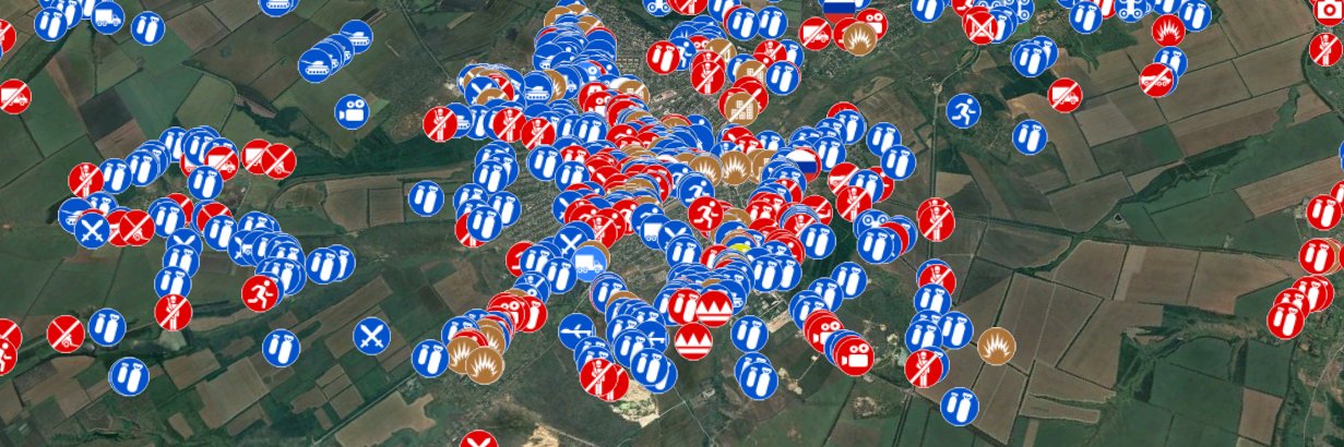
 --- Pictured: GeoConfirmed’s admin team verified geolocations conducted by the GeoConfirmed volunteer community, as well as contributions from other volunteers, related to the Ukraine–Russia conflict. Over 50,000+ GeoConfirmed locations where events occured. (geoconfirmed.org/ukraine)
GeoConfirmed tweet media
English
99
456
3.2K
455.6K
GeoConfirmed
GeoConfirmed@GeoConfirmed·
GeoConfirmed Iran. The moment of an explosion in front of a building and a Matzman and Merutz bicycle shop on Menakhem Begin highway in Tel Aviv, Israel 32.071067, 34.789149 3QCQ+CMC Tel Aviv-Yafo, Israel GeoLocated by @Shayan86 Geolocation: x.com/Shayan86/statu… Location: geoconfirmed.org/iran/7bfc5506-… Sources: x.com/Shayan86/statu… Visit our map: geoconfirmed.org/iran
Shayan Sardarizadeh@Shayan86

Footage filmed from a vehicle shows the moment of an explosion in front of a building and a Matzman and Merutz bicycle shop on Menakhem Begin highway in Tel Aviv, Israel. Location: 32.071067,34.789149 @GeoConfirmed

English
1
1
24
8.9K
GeoConfirmed
GeoConfirmed@GeoConfirmed·
GeoConfirmed Iran. Mayuree Naree, the “ghost ship,” ran aground on a beach near Qeshm Island in the Strait of Hormuz after being hit by an Iranian missile. 26.8915, 56.1615 V5R6+HHX Ramchah, Hormozgan Province, Iran GeoLocated by @tom_bike Location: geoconfirmed.org/iran/a539b919-… Sources: x.com/tom_bike/statu… More information: x.com/sentdefender/s… Visit our map: geoconfirmed.org/iran
Tom Bike@tom_bike

Iran 🇮🇷 missile hit MAYUREE NAREE 🇹🇭 ghost ship spotted YESTERDAY 👇 grounded in Strait of Hormuz Qeshm Island beach at 26.8915, 56.1615 located by @TankerTrackers Someone could check on 3 unaccounted for crew remains POSS on hit engine room. @GeoConfirmed

English
0
1
25
7.6K
GeoConfirmed
GeoConfirmed@GeoConfirmed·
GeoConfirmed Iran. IDF troops driving North in Houla, Lebanon 33.211828, 35.527004 6G6G+PRJ Houla, Lebanon GeoLocated by @MarioLeb79, @GeoRaccoon and @Stinky915846091 Geolocation: Geo: x.com/MarioLeb79/sta… Proof: x.com/GeoRaccoon/sta… x.com/Stinky91584609… Location: geoconfirmed.org/iran/9434f670-… Sources: x.com/MarioLeb79/sta… t.me/amitseg/20820 Visit our map: geoconfirmed.org/iran
 𝓂𝒶𝓇𝒾𝑜🇱🇧🇬🇧🇦🇪@MarioLeb79

English
3
3
26
8.8K
GeoConfirmed
GeoConfirmed@GeoConfirmed·
GeoConfirmed Iran. Point of view, looking west - Strike in the direction of a fishing port in Bandar-e Deylam, Bushehr Province, Iran 30.067034, 50.165297 3588+R47 Bandar-e Deylam, Bushehr Province, Iran GeoLocated by @Mitch_Ulrich Geolocation: x.com/Mitch_Ulrich/s… Location: geoconfirmed.org/iran/e9738d49-… Sources: x.com/Vahid/status/2… Visit our map: geoconfirmed.org/iran
Vahid Online@Vahid

'#بندر_دیلم استان بوشهر ساعت ۱۲' ویدیوی دریافتی از دود انفجار یک حمله، یکشنبه ۹ فروردین #Iran

English
1
0
22
7.3K
GeoConfirmed
GeoConfirmed@GeoConfirmed·
GeoConfirmed Iran. Iran-backed militias targeted a military transport plane that belongs to the Iraqi Air Force in Baghdad International Airport. Point of view - 33.247827, 44.240453 66XR+45P Baghdad, Iraq GeoLocated by @Mitch_Ulrich Geolocation: Based on x.com/Mitch_Ulrich/s… Location: geoconfirmed.org/iran/acf8fa62-… Sources: Vid x.com/Tammuz_Intel/s… Pic x.com/Tammuz_Intel/s… Visit our map: geoconfirmed.org/iran
Tammuz Intel@Tammuz_Intel

Iran-backed militias targeted a military transport plane that belongs to the Iraqi Air Force in Baghdad International Airport. 🇮🇶

English
1
2
23
6.6K
GeoConfirmed
GeoConfirmed@GeoConfirmed·
GeoConfirmed Iran. A US Air Force Boeing E-3C Sentry aircraft, also known as an AWACS, (#AE11EA, 81-0005) was destroyed during a reported combined drone and missile attack on Prince Sultan Air Base in Saudi Arabia on March 27, 2026. This is another location from the reported damaged or destroyed KC-135 in yesterday’s attack. 24.063702, 47.546077 3G7W+FCP Industrial Area Saudi Arabia GeoLocated by @giK1893 Geolocation: Geo: x.com/giK1893/status… Proof: x.com/Digi_Cld_Surfe… Location: geoconfirmed.org/iran/59cfa517-… Sources: x.com/TheIntelFrog/s… PS: Special thanks to @Kubag1414, one of our admins was to motivated and he pointed out the mistake Visit our map: geoconfirmed.org/iran
TheIntelFrog@TheIntelFrog

Photos have surfaced showing extensive damage to US Air Force E-3 Sentry #AE11EA 81-0005 following the drone and missile attack at Prince Sultan Air Base yesterday that also damaged several KC-135s.

English
6
29
192
23K
GeoConfirmed
GeoConfirmed@GeoConfirmed·
GeoConfirmed Iran. Destroyed infrastructure and heavy fire is observed in the 'Deputy of Information and Communication Technology of the IRGC' barracks, Tehran, Iran. 35.73514, 51.24375 P6PV+3G2 Tehran, Tehran Province, Iran GeoLocated by @Mitch_Ulrich Reported involved units: Islamic Revolutionary Guard Corps (IRGC) → Islamic Republic of Iran Armed Forces Geolocation: x.com/Mitch_Ulrich/s… Location: geoconfirmed.org/iran/93c66d30-… Sources: Pic1 x.com/Vahid/status/2… Vid1 x.com/Vahid/status/2… Visit our map: geoconfirmed.org/iran
Vahid Online@Vahid

تصاویر دریافتی مربوط به 'حمله قبلی به یک سوله در کوهک منطقه ۲۲ تهران در ساعت ۴:۱۰ بامداد جمعه ۷ فروردین' #Iran #Tehran

English
1
7
29
9.2K
GeoConfirmed
GeoConfirmed@GeoConfirmed·
GeoConfirmed Iran. Explosion seen following a drone impact in compound in DUHOK, Iraq. Compound is claimed to belong to Iranian Kurdish opposition. 36.843074, 43.025982 R2VG+69H Duhok, Iraq GeoLocated by @acceladealer Geolocation: x.com/acceladealer/s… Location: geoconfirmed.org/iran/8ef410e5-… Sources: (1/2) x.com/acceladealer/s… x.com/acceladealer/s… (2/2) x.com/acceladealer/s… t.me/nayaforiraq/65… Visit our map: geoconfirmed.org/iran
acceladealer@acceladealer

source 1: t.me/nayaforiraq/65… source 2: t.me/nayaforiraq/65…

English
1
1
15
6.7K
GeoConfirmed
GeoConfirmed@GeoConfirmed·
GeoConfirmed Iran. A "Scientific Research Center" building on the Iran University of Science and Technology (IUST) campus was destroyed by an air strike. Tehran, Iran. 35.745081, 51.502302 PGW2+2WM Tehran, Tehran Province, Iran GeoLocated by @gharbill Geolocation: x.com/gharbill/statu… Location: geoconfirmed.org/iran/5c60506a-… Sources: x.com/Vahid/status/2… Visit our map: geoconfirmed.org/iran
Vahid Online@Vahid

ویدیوی دریافتی با شرح: 'دانشگاه علم و صنعت #تهران حوالی ۲:۳۰ بامداد' شنبه ۸ فروردین #Iran #Tehran

English
1
2
23
7.4K