Hurricane Tracker App

26.9K posts

Hurricane Tracker App banner
Hurricane Tracker App

Hurricane Tracker App

@hurrtrackerapp

Best Hurricane Tracker App! 1st tracking app on iOS. Over 800K users! Download free today! https://t.co/wsIHf5yVOG

Colorado Springs, CO Katılım Mart 2011
128 Takip Edilen95.5K Takipçiler
Hurricane Tracker App retweetledi
Dr. Levi Cowan
Dr. Levi Cowan@TropicalTidbits·
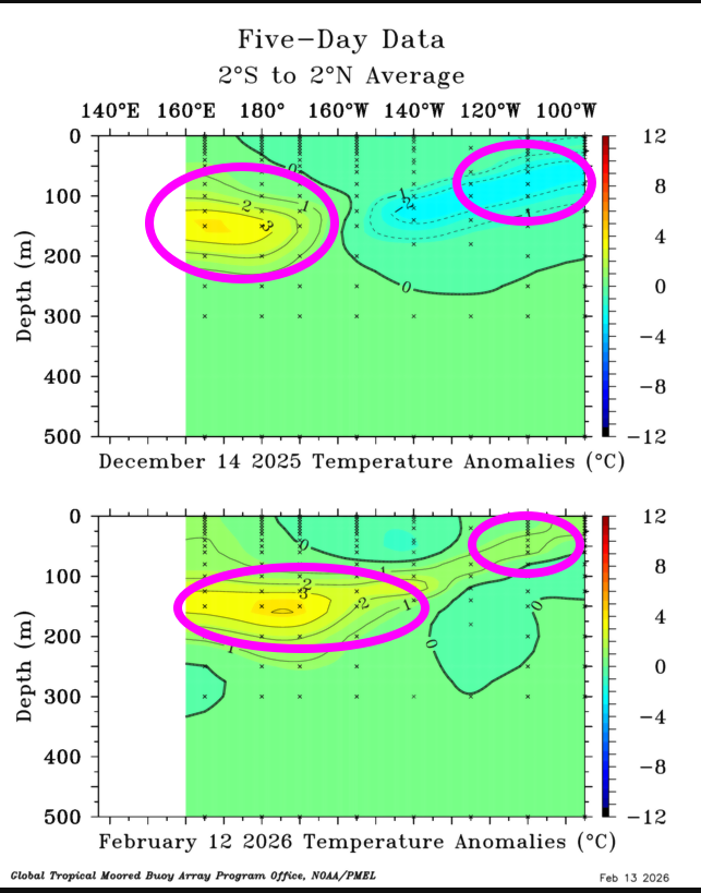
Looks like a flip from La Niña to El Niño is on the way this upcoming hurricane season. The equatorial Pacific thermocline has deepened over the last 2 months as upper ocean heat anomalies discharge eastward, which should eventually reverse the SST anomaly at the surface in the coming months. 
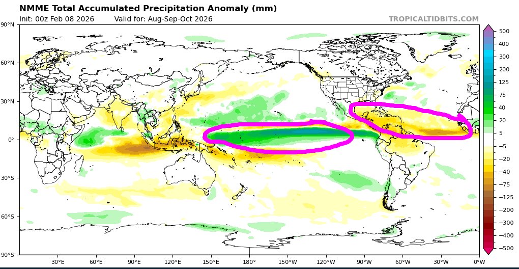
El Niño typically suppresses Atlantic hurricane activity through changes in average wind shear and convective instability. In recent years, the Atlantic has shown the potential to offset these negative impacts if its own water is warm enough to distort the base state (see 2023). For now, seasonal models don't foresee that this year, with an intense dipole in precipitation anomalies evident in the current NMME forecast for peak hurricane season, indicating a dominant El Niño pattern. A super active hurricane season would be unlikely if this forecast verifies, but that also wouldn't guarantee a small number of storms that strike land. As always, it's best to be prepared just in case every single hurricane season if you live in an area prone to hurricanes. This can include areas well inland, as we have unfortunately seen in the southeastern U.S. in recent years.
Dr. Levi Cowan tweet mediaDr. Levi Cowan tweet mediaDr. Levi Cowan tweet media
English
17
73
333
31.8K
Hurricane Tracker App retweetledi
Matt Devitt
Matt Devitt@MattDevittWX·
Hurricane Season isn't over, but it's quickly winding down. Here's a look at first predictions vs actual. Although a large range, NOAA's forecast did pretty well. Numbers were near to slightly below normal. ACE (Accumulated Cyclone Energy) was slightly above normal. For the United States it felt like a quiet year, for Jamaica, historically active. At the end of the day, it's not about the numbers, it's about actual IMPACT. @WINKNews
Matt Devitt tweet media
English
9
31
119
19K
Hurricane Tracker App retweetledi
Philip Klotzbach
Philip Klotzbach@philklotzbach·
#Hurricane #Melissa has made landfall in Jamaica as a Category 5 hurricane with max winds of 185 mph. Melissa breaks the old strongest Jamaican hurricane landfall record set by Hurricane Gilbert in 1988 (130 mph winds).
GIF
English
44
132
357
45.8K
Hurricane Tracker App retweetledi
Michael Lowry
Michael Lowry@MichaelRLowry·
With a pressure of 892 mb, Melissa is tied for the 3rd most intense Atlantic basin hurricane on record (by pressure) and if it holds at 185 mph through landfall in Jamaica, it would tie Dorian in 2019 as the strongest landfalling Atlantic basin hurricane on record.
Michael Lowry tweet media
Tropical Cowboy of Danger@FlynonymousWX

Hurricane Melissa still photo thread… most of these are taken with a @CanonUSApro R5 with 11mm lens but a few were taken with my iPhone. If you are media and want to use them please go look on DVIDs.

English
1
27
102
20.2K
Hurricane Tracker App retweetledi
Dr. Levi Cowan
Dr. Levi Cowan@TropicalTidbits·
Data from the aircraft indeed indicated extreme turbulence, prompting a longer than usual loitering inside the eye after penetration. Hoping the crew is all safe and uninjured.
403rd Wing@403rdWing

English
12
103
960
146.8K
Hurricane Tracker App retweetledi
National Hurricane Center
National Hurricane Center@NHC_Atlantic·
11AM #Melissa Update: #Jamaica THIS IS AN EXTREMELY DANGEROUS AND LIFE-THREATENING SITUATION! TAKE COVER NOW!
National Hurricane Center tweet mediaNational Hurricane Center tweet media
English
55
793
2.3K
378.6K
Hurricane Tracker App retweetledi
Philip Klotzbach
Philip Klotzbach@philklotzbach·
So far, the 2025 Atlantic #hurricane season is above normal for major hurricanes/days, near-normal for Accumulated Cyclone Energy and named storms, and slightly below-normal for other metrics.
Philip Klotzbach tweet media
English
4
33
136
15.4K
Hurricane Tracker App retweetledi
National Hurricane Center
National Hurricane Center@NHC_Atlantic·
Hurricane #Melissa Advisory 26A: Melissa Expected to Bring Catastrophic and Life-Threatening Winds, Flooding, and Storm Surge to Jamaica Later Tonight and On Tuesday. hurricanes.gov
English
42
214
622
164.9K
Hurricane Tracker App retweetledi
National Hurricane Center
National Hurricane Center@NHC_Atlantic·
5pm EDT Oct 27th Key Messages for Category 5 #Hurricane #Melissa: #Jamaica: Remain in your safe shelter & do not venture outside. Catastrophic, life-threatening flash flooding & numerous landslides through Tuesday as Melissa's core moves ashore. hruricanes.gov
National Hurricane Center tweet mediaNational Hurricane Center tweet media
English
20
315
699
174.8K
Hurricane Tracker App retweetledi
Philip Klotzbach
Philip Klotzbach@philklotzbach·
#Hurricane #Melissa's pressure has dropped to 906 mb - the 4th lowest for an October Atlantic hurricane on record. Three lowest are: Wilma (2005 - 882 mb), Milton (2024 - 895 mb), Mitch (1998 - 905 mb). Pressures have been recorded consistently for Atlantic hurricanes since 1979.
GIF
English
10
127
418
42.2K
Hurricane Tracker App retweetledi
Alex Boreham
Alex Boreham@cyclonicwx·
And there we have it. #Melissa's WV eye temperature has broken -5°C, making it warmer than any other eye observed through geostationary water vapor imagery. Takes an upper echelon warm core for this
Alex Boreham tweet mediaAlex Boreham tweet media
English
6
92
429
236.6K
Hurricane Tracker App retweetledi
Philip Klotzbach
Philip Klotzbach@philklotzbach·
#Hurricane #Melissa is now forecast to reach Category 5 intensity on Monday. If it does so, it would be 3rd Cat 5 of the 2025 Atlantic #hurricane season (Erin & Humberto were other 2). Only 1 other Atlantic season on record has had >2 Cat. 5s: 2005 (Emily, Katrina, Rita, Wilma)
GIF
English
7
56
184
16.5K
Hurricane Tracker App retweetledi
National Hurricane Center
National Hurricane Center@NHC_Atlantic·
2pm EDT 25 Oct Intermediate Advisory: #Melissa has become a #hurricane with maximum sustained winds of 75 mph. Rapid Intensification is expected, and Melissa is forecast to become a major hurricane tomorrow. Latest info at hurricanes.gov
GIF
English
32
399
819
141.2K
Hurricane Tracker App retweetledi
National Hurricane Center
National Hurricane Center@NHC_Atlantic·
11am 25 Oct Key Messages for #Melissa: #Jamaica prep should be completed today. Melissa’s slow motion brings multi-day damaging winds+heavy rainfall, catastrophic flash flooding, landslides, damage, long-duration power communication outages, isolation. hurricanes.gov
National Hurricane Center tweet mediaNational Hurricane Center tweet media
English
20
136
354
77.6K
Hurricane Tracker App retweetledi
Andy Hazelton
Andy Hazelton@AndyHazelton·
Despite the deterministic GFS continuing to insist on a north/northeast turn into Hispaniola, the GEFS is steadily trending SW, with fewer members showing rapid development. This seems consistent with the structure today. Can't rule out a landfall there for sure, but if trends like this continue, it would increase the risk of a track towards points further west in the Caribbean.
GIF
English
9
21
203
22.5K
Hurricane Tracker App
Hurricane Tracker App@hurrtrackerapp·
Here's the initial NHC track forecast for #Melissa. Hurricane watch for portions of Haiti. We will be tracking this one for many days.
Hurricane Tracker App tweet media
English
0
12
56
8.3K
Hurricane Tracker App retweetledi
National Hurricane Center
National Hurricane Center@NHC_Atlantic·
Tropical Storm #Melissa Advisory 1: The 13th Tropical Storm of the Season Forms Over the Central Caribbean Sea. Hurricane Watch Issued For Portions of Haiti. hurricanes.gov
English
11
126
312
145.9K