Irish Weather News

8.1K posts

Irish Weather News banner
Irish Weather News

Irish Weather News

@iWeatherNews

Weather tweets from Ireland: Weather as it happens with Daily forecasts, pictures, live updates and weather warnings

Dublin City, Ireland Katılım Ocak 2012
8.4K Takip Edilen21.1K Takipçiler
Irish Weather News retweetledi
Marine Institute
Marine Institute@MarineInst·
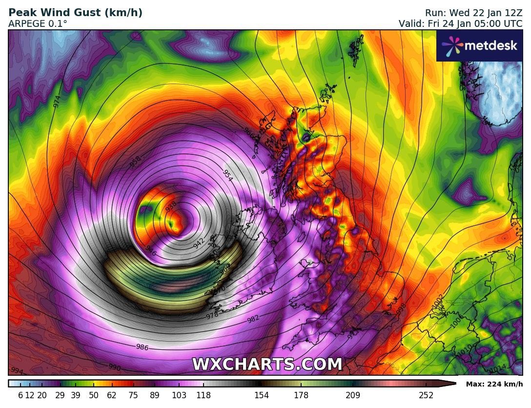
See real-time measurements from the Irish Marine Data Buoy Observation Network when #StormÉowyn passes over #Ireland at marine.ie/databuoy During Storm Opheila in October 2017, the M5 Data Buoy recorded a wave off the south-east coast of Ireland measuring a height of 17.81 metres – that’s almost the height of a six-storey building! @meteireann
Marine Institute tweet media
English
0
35
72
27.2K
Irish Weather News retweetledi
Paul Blight
Paul Blight@PaulBlight6·
#StormEowyn is now beginning to show the first ominous signs of cyclogenesis. The Airmass imagery shows a cloud head beginning to develop to the North of the wide baroclinic zone to the south of Newfoundland (highlighted below) This cloud head marks the 1st sign that a deepening low pressure is under cloud mask. The Low will cross through the Jet Core tonight and move into the highly divergent left exit region on Thurs Morning. The 12Z Models have maintained the track and depth of the 00Z Run. The 12Z GFS Ensemble showing excellent agreement to support the earlier 06Z ECMWF Ensemble. It must be reiterated again that #StormEowyn is likely to be one of the strongest storms to hit Ireland in many many years with wind gusts to 90-95mph even inland to the East of Galway Bay, and winds gusting to over 100mph along the coast, perhaps as high as 110mph along places like Mace Head. Risk has increased for strong 90mph winds through the Central Belt of Scotland and winds to 100mph around the North Channel, Solway Firth. Winds also higher in parts of SW Scotland & extending slightly further north into the area north of Glasgow/Edinburgh. Peak depth down to around 938mbs as the storm slams into the British Isles, likely to brush close to Belmullet Island. Gusts in the Isle of Man and around the Irish Sea will be around 85-90mph, Inland gusts over Northern Ireland to 90mph. I see nothing to downplay any aspects of this storm in tonight's guidance. I expect RED Danger to life warnings to be issued on Thursday Morning for parts of SW Scotland, Northern Ireland, Northern Irish Sea coasts. #StormEowyn will be an extremely dangerous storm. We are very fortunate to have the NOAA Hurricane Hunters in Shannon where they will be flying NOAA42 KERMIT into #StormEowyn to gather extremely rare and extremely valuable research into this storm over the next couple of days. Currently in Shannon it will be flying research missions to help our understanding of such powerful cyclogenesis. I look forward to seeing their valuable research.
Paul Blight tweet mediaPaul Blight tweet mediaPaul Blight tweet mediaPaul Blight tweet media
English
44
197
833
237.8K
Irish Weather News
Irish Weather News@iWeatherNews·
#StormEowyn is forecast to be an extremely powerful and violent storm across much of Ireland. Widespread disruption and damage property and infrastructure is likely. Please heed the warnings
Irish Weather News tweet mediaIrish Weather News tweet mediaIrish Weather News tweet mediaIrish Weather News tweet media
English
0
0
2
741
Irish Weather News retweetledi
Cork Safety Alerts
Cork Safety Alerts@CorkSafetyAlert·
A roof has just come off a building at Youghal Strand. Emergency services are en route. Avoid the area if possible! #StormAgnes
English
68
278
1.1K
857.5K
Irish Weather News
Irish Weather News@iWeatherNews·
Such amazing images! #stormAgnes
EUMETSAT@eumetsat

2⃣ views of #StormAgnes below, as seen by #MTGI1 this morning at 09:00 UTC. (L) shows the cloud phase RGB and (R), we have the true colour image - both blended with night-time infrared imagery 🛰️ Please note that this is preliminary commissioning data, not for operational use.

English
0
2
11
2.9K
Irish Weather News retweetledi
RTÉ News
RTÉ News@rtenews·
Eight people have been evacuated from homes in the Clontarf area of Dublin after flash flooding following heavy rain | Read more: rte.ie/b/1398326
English
111
136
650
421.8K
Josh Deltener
Josh Deltener@JoshDeltener·
Who needs a bluesky invite?
English
3
0
0
126
Irish Weather News retweetledi
Met Éireann
Met Éireann@MetEireann·
📈July 2023 was provisionally Ireland’s wettest July on record 🌧️ ▶️217% of the 1981-2010 Long Term Average rainfall fell ▶️4 times more rain than July 2022 Find out more in our article 📰 met.ie/july-2023-prov…
Climate Services @ Met Éireann@METclimate

July 2023: Provisionally Ireland’s wettest July on record with 217% of its LTA and 4 times more than July 2022. 17 Synoptic stations had over 200% of their LTA and 12 broke their July rainfall records. See more here met.ie/july-2023-prov…

English
1
18
29
28.9K
Irish Weather News
Irish Weather News@iWeatherNews·
Does anyone have a Bluesky invite to spare please?
English
0
0
1
548
Boris Ryvkin
Boris Ryvkin@BRyvkin·
Greetings from rainy, but lovely, Dublin. And yet the rain left behind one of the biggest and clearest rainbows I’ve ever seen - over the River Liffey.
Boris Ryvkin tweet mediaBoris Ryvkin tweet mediaBoris Ryvkin tweet media
English
7
0
33
1.7K
Irish Weather News
Irish Weather News@iWeatherNews·
Update! Status Red Warning for Cork & Kerry & Status Orange warning area extended. Warnings valid from 3am Friday #StormEunice #Ireland
Irish Weather News tweet media
English
1
15
42
0