johnantap

1.4K posts

johnantap banner
johnantap

johnantap

@johnantap

Emergency Management. Higher Education / Research and Development #wtxTwitter #EMGTwtter #Emergency #Crisis

United States Katılım Ağustos 2020
3.1K Takip Edilen1K Takipçiler
johnantap retweetledi
MyRadar Weather
MyRadar Weather@MyRadarWX·
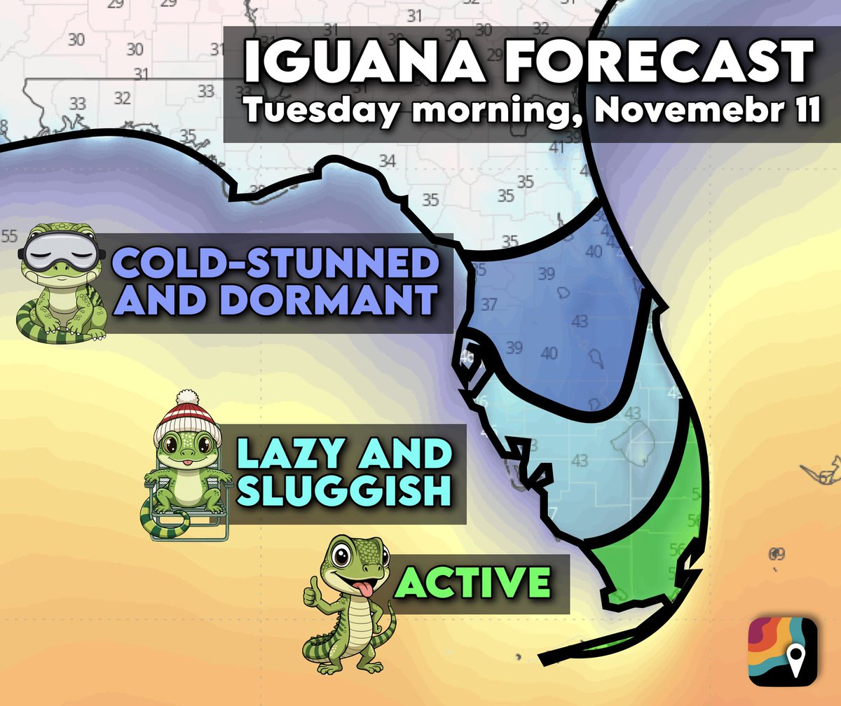
IGUANA ADVISORY for Florida on Monday night/Tuesday morning, November 11! Iguanas become sluggish and “cold-stunned” when temperatures drop into the 40s. Below 40 degrees, they can be dormant and immobile. Iguanas are cold-blooded reptiles that rely on external heat to regulate their body temperatures. In central Florida along the I-4 corridor to Lake Okeechobee, the iguanas may become paralyzed due to several hours of temperatures in the upper 30s to lower 40s. Iguanas are rarely found in northern parts of the Peninsula, but there have been green iguana reports as far north as Alachua, Highlands, Hillsborough, Indian River and St. Lucie Counties. A few record temperatures are possible. Jacksonville should set a record at 34 degrees. Lakeland International Airport is projected to dip to 38, far below the record of 44 degrees. Brooksville, Florida, north of Tampa, is predicted to dip to around 34 degrees, which will threaten a record from 1894. And if Orlando dips into the 30s, it will be the earliest such occurrence since 1993.
MyRadar Weather tweet media
English
17
85
426
57.4K
johnantap retweetledi
Nahel Belgherze
Nahel Belgherze@WxNB_·
NOAA aerial imagery is coming in. Hurricane Melissa literally turned western Jamaica from green to brown. Vegetation damage is immense — recovery will take years.
GIF
English
114
785
3K
785.5K
johnantap retweetledi
Backpirch Weather
Backpirch Weather@BackpirchCrew·
Hurricane Melissa has wiped out power for the vast majority of west and central Jamaica.
Backpirch Weather tweet media
English
38
1.5K
7.6K
269.4K
johnantap retweetledi
CIRA
CIRA@CIRA_CSU·
NOAA-20 captured spectacular imagery of Hurricane Melissa as it made landfall on Jamaica yesterday afternoon.
English
1
30
103
6.2K
johnantap retweetledi
Nature is Amazing ☘️
Nature is Amazing ☘️@AMAZlNGNATURE·
The US Air Force Reserve Hurricane Hunters flew straight through Category 5 Hurricane Melissa, capturing an incredible view from inside the storm’s eye.
English
865
13.6K
110.4K
5M
johnantap retweetledi
R A W S A L E R T S
R A W S A L E R T S@rawsalerts·
🚨#BREAKING: Listen as terrifying screams of extreme wind reaching 185+ mph tear through Treasure Beach, Jamaica where a catastrophic, life-threatening Category 5 hurricane is unleashing its full force. The storm's powerful eyewall is now directly over the area, battering everything in its path.
English
335
2.6K
15.6K
1.8M
johnantap retweetledi
The Weather Channel
The Weather Channel@weatherchannel·
An incredible look inside the eye of Hurricane Melissa via NOAA's Hurricane Hunters ⬇️
English
23
192
638
74.9K
johnantap retweetledi
Weather Jamaica
Weather Jamaica@weatherjamaica·
Infrared satellite images of the Caribbean continue to show Major Hurricane Melissa moving from east to west across the waters south of Jamaica, spinning and intensifying as she tries her hardest to reach Category 5 status on this Sunday afternoon, October 26, 2025 at 3 PM.
English
4
58
255
33.6K
johnantap retweetledi
FOX Weather
FOX Weather@foxweather·
SAVING LIVES: Jamaica's Minister of Labor and Social Security Pearnel Charles Jr. said the country is taking every effort to “save lives” ahead of Hurricane Melissa’s worst impacts. Residents on the south-central part of the island are being told to seek higher ground.
English
10
99
311
34.2K
johnantap retweetledi
Robert Ray
Robert Ray@RobertRayWx·
#Kingston, 1 million people here and they are preparing this Saturday evening, monster #hurricanemelissa is strengthening. Stores are closing, shelves being emptied as wind speeds could exceed 150 mph with feet of rain. Please be vigilant #Jamaica. God speed. @foxweather
English
46
155
908
185.2K
johnantap retweetledi
Adrian Linares
Adrian Linares@AdrianLinares28·
Hurricane Wilma 10-second animation via @BMcNoldy of surface wind and pressure from the WRF model as it moved across South Florida. Notice how wind speeds dramatically decrease over land due to friction. #FLwx
English
7
15
265
27.9K
johnantap retweetledi
Mike Gagliardi (FL Weather)
Mike Gagliardi (FL Weather)@Mike__Gagliardi·
Jamaica Residents: This is a great share. This is the 100-year flood map for riverine flooding. If you live in a flood plain highlighted in blue, I urge you to consider relocating elsewhere for the duration of #Melissa. If you know anyone who lives in these areas, alert them.
Mike Gagliardi (FL Weather) tweet media
English
30
695
1.4K
288.6K
johnantap retweetledi
Backpirch Weather
Backpirch Weather@BackpirchCrew·
7 years ago today, the first Category 5 Hurricane to make landfall in the United States since 1992 ripped across the beaches of the Florida Panhandle.
English
17
56
580
46.5K
johnantap retweetledi
Backpirch Weather
Backpirch Weather@BackpirchCrew·
Satellite Image of the Day. Category 4 Hurricane Teddy on September 17th, 2020.
Backpirch Weather tweet media
English
3
9
68
1.9K
johnantap retweetledi
Nick Krasznavolgyi
Nick Krasznavolgyi@NickKrasz_Wx·
OTD in 2019: Hurricane Dorian reached its peak intensity as a Category 5 as it made landfall on The Bahamas. Dorian had maximum 1-minute sustained winds of 160 knots (185 mph) and a minimum central pressure of 910 mb. Here is a VIIRS image of Dorian, courtesy of @CocoasCola.
Nick Krasznavolgyi tweet media
English
1
14
79
4.1K
johnantap retweetledi
Weather History
Weather History@weather_history·
September 1-3, 2019: Category 5 Hurricane Dorian brought devastation to the Bahamas. For two days, islands in the archipelago experienced relentless winds over 170-180 mph, 20-25 feet of surge, and up to 3' of rain. Officially, Dorian killed 70 people in the country. #wxhistory
Weather History tweet mediaWeather History tweet mediaWeather History tweet mediaWeather History tweet media
English
3
23
125
6.2K
johnantap retweetledi
Kacper
Kacper@KacperWx·
On this day 6 years ago, slow-moving Hurricane #Dorian made two catastrophic landfalls over the #Bahamas as a powerful Category 5 hurricane (160kts). Unusual for such intensity, cloud tops were widely above -70C given the low tropopause height at Dorian's latitude.
Kacper tweet mediaKacper tweet mediaKacper tweet mediaKacper tweet media
English
1
10
71
4K
johnantap retweetledi
MyRadar Weather
MyRadar Weather@MyRadarWX·
This is the scariest weather alert ever issued in the United States. 20 years ago today, at 10:11 a.m. on Sunday, August 28, 2005, the National Weather Service in New Orleans, Louisiana released the infamous "doomsday statement." It was a first-of-its-kind warning, and is downright chilling. Moments earlier, Katrina had intensified into a Category 5 behemoth with 175 mph winds, and was on a crash course with southeast Louisiana. Forecasts called for a Category 4 or 5 strike on New Orleans within 24 hours. Robert Ricks Jr., a forecaster at the New Orleans NWS office, issued the following dire warning: National Weather Service New Orleans LA 10:11 AM CDT Sun Aug 28 2005 ...Devastating damage expected... Hurricane Katrina, a most powerful hurricane with unprecedented strength, rivaling the intensity of Hurricane Camille of 1969. Most of the area will be uninhabitable for weeks, perhaps longer. At least one half of well-constructed homes will have roof and wall failure. All gabled roofs will fail, leaving those homes severely damaged or destroyed. The majority of industrial buildings will become non-functional. Partial to complete wall and roof failure is expected. All wood-framed low-rising apartment buildings will be destroyed. Concrete block low-rise apartments will sustain major damage, including some wall and roof failure. High-rise office and apartment buildings will sway dangerously, a few to the point of total collapse. All windows will blow out. Airborne debris will be widespread and may include heavy items such as household appliances and even light vehicles. Sport utility vehicles and light trucks will be moved. The blown debris will create additional destruction. Persons, pets, and livestock exposed to the winds will face certain death if struck. Power outages will last for weeks, as most power poles will be down and transformers destroyed. Water shortages will make human suffering incredible by modern standards. The vast majority of native trees will be snapped or uprooted. Only the heartiest will remain standing but be totally defoliated. Few crops will remain. Livestock left exposed to the winds will be killed. An inland hurricane wind warning is issued when sustained winds near hurricane force, or frequent gusts at or above hurricane force, are certain within the next 12 to 24 hours. Once tropical storm and hurricane force winds onset, do not venture outside!" Within an hour, the mayor of New Orleans issued the first-ever mandatory evacuation of the city. Katrina came ashore on August 29 as a slightly-weakened 125 mph Category 3 hurricane. The worst damage didn't come from wind, but rather levee failures. Rob Perillo, a longtime meteorologist in Lafayette, Louisiana, described the statement as "one of the first hurricane bulletins that ‘humanized’ the forecast." Josh Morgerman, the world's most prolific hurricane chaser, concurred. "It turned out that Katrina’s winds were nowhere near as strong as what’s described in that bulletin, the water impacts were actually *worse* than feared—both the levy failures in the city and the gargantuan storm surge in Mississippi," he wrote. "So, in the end, despite how crazy it sounded, the bulletin was right. It correctly predicted a massive, catastrophic, generational impact." Bryan Norcross, the "Hero of Hurricane Andrew", which hit South Florida in 1992, discussed the challenge of communicating an "extreme, unsurvivable event" like Katrina. "The only choice is to assume the odds are 100% that it will occur," he wrote. "If you're responsible for communicating the hazard, you don't want to leave any room for 'maybe it won't be so bad.'" He said the New Orleans NWS office had taken the same approach.
MyRadar Weather tweet media
English
15
172
742
93.8K