
Lisa Carosso
341 posts

Lisa Carosso
@kamassbb
Big Brother fan, love my family and New England Patriots.
Port Charlotte, FL Katılım Temmuz 2023
184 Takip Edilen64 Takipçiler

TROPICAL UPDATE: NHC increases the odds for development to 40% with Invest 94L in the Atlantic as of Sunday afternoon. Here are my thoughts as of Sunday:
1. Next name is "Nadine." I want to be clear that this area is completely unrelated and entirely different from the fake viral post a couple days ago where someone took an old cone from Helene and said it was Nadine heading to Florida. This is a separate, new area.
2. Pretty unusual to have a system to track in this part of the Atlantic for Mid-October. Warmer than average surface water temps is one of these reasons why.
3. Pretty straight forward track in the short-term, then it approaches the Caribbean. Models diverge into early next week when it's near Hispaniola, Cuba and the Bahamas. Some bring it into the Caribbean, some kiss it goodbye with a hard turn north into the Atlantic. We're in the time of the year now where cold fronts and digging troughs play a big role in where these can go.
4. As a result, too early to know where it goes, how strong it will be...or even if it forms! Odds aren't at 100% at the moment either.
5. As we go deeper into Fall, the Gulf of Mexico will start to gradually cool down. Milton also helped accelerate things by runoff and upwelling in the Gulf. We also have a Fall front on track for this week too. Although still warm, Milton was able to trim off a few degrees.
6. Remember that every storm is different and not all are destined to come to Florida. I know we've had Debby, Helene and Milton during this active year for us, but the other 10 storms this season avoided us. There are still a lot of places that storms can go across the Atlantic basin well outside of Florida. Hopefully, out to sea!
For now, keep enjoying some sunshine and cleaning up as we try to get our lives back together. If anything ever is a threat, you'll know about it here. I'll keep giving you daily updates that you can trust without the hype. Thanks everyone!
- Matt Devitt WINK Weather
Matt Devitt@MattDevittWX
TROPICAL UPDATE: Odds for development increase to 40% with #Invest94L. Plenty of time to watch it across the Atlantic. Next name is #Nadine. I'll have thoughts about this one within the hour. @WINKNews
English
@hamsterwatch You did a great job as always. Thank you for making me laugh and keeping me up to date!
English
@RpsAgainstTrump Yes!! We do love eachother. But politics are strictly off the discussion list. It's kids and games and family talk absolutely no politics. I have 5 children that have polar opposite ideas and some are reasonable and see the whole picture but keep their mouths closed.
English

Do you get along with your MAGA friends/family?
English


Also, stay tuned for an announcement of the new jury roundtable host :) #bb26
English

I am proposing a plan that will allow Medicare to cover in-home health care.
English
UPDATE: New 12z consensus model is in. They are historically better performing over the years. Magenta is the most recent, Red is 12 hours ago, Orange is 24 hours ago. More adjustments, both north or south, will continue. Look for consistency. Southwest Florida, please take this seriously. I'll continue to keep you updated on @WINKNews.

English
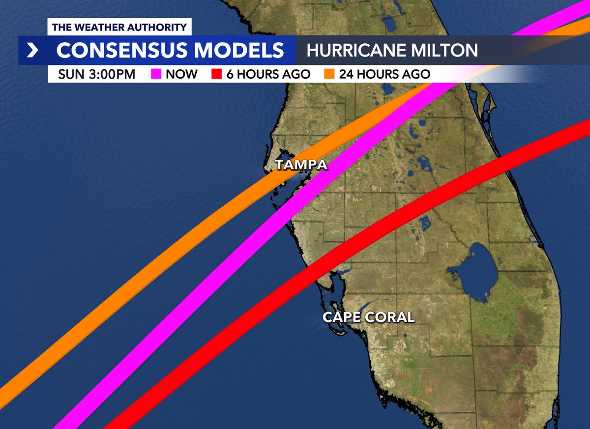
UPDATE: New 18z models are in with some classic windshield wiper action. Magenta is the most recent, Red is 6 hours ago, Orange is 24 hours ago. Slight shift north. This will continue to happen, both north or south in the hours and days ahead. Look for consistency going forward. Tampa Bay to Southwest Florida should be taking this storm seriously. I'll continue to keep you updated on @WINKNews.
English
@MattDevittWX Thank you for explaining. Prayers for all those in Milton's path.
English
@kamassbb No, no. That’s just the intensity when it’s more inland. Still a powerful storm, no good news yet. Please stay alert to the forecast.
English
NEW ADVISORY: Here's the latest on #Milton from the NHC. Stick with Southwest Florida's WINK Weather Team for updates 24/7 both on TV and online. winknews.com/weather/

English
Best way to think about it is that Florida will see a one-two punch. The first one will bring us rain Sunday into Monday with an area of low pressure along a stalled out front. Then the 2nd, main punch from tropical storm or hurricane approaches on Tuesday into Wednesday. @WINKNews
English

WATCH LIVE: Trump speaks at town hall event in Fayetteville, North Carolina twitter.com/i/broadcasts/1…
English


Lisa Carosso retweetledi

Lisa Carosso retweetledi

Trump supporters champion their candidate as a defender of free speech. Really? This guy?
English
It's frustrating as a meteorologist and for our locals that we have just *one* tide sensor from NOAA to look at across Lee and Charlotte counties to see if surge and water levels are going up, leveling off or going down during tropical systems in real time. That was the #1 thing people wanted to know as water was approaching or going into their homes during Helene, Debby and Ian. No two counties in the contiguous United States have had to endure more Cat 4 landfalls in the past 2 decades than Lee and Charlotte in Southwest Florida. Over 1 million combined people live in those counties, largely along the coast.
Charlotte County just had their highest surge levels in decades from Helene and I wasn't able to look at anything in real time for Punta Gorda or Port Charlotte. Instead, I had to look miles up the Myakka River in Sarasota County, ask viewers via email or Facebook their status, or look at cameras.
@NOAA, let's figure out a way we can fix this. At a minimum, we need one on Fort Myers Beach and especially one in Port Charlotte / Punta Gorda. I typically have to find out days or weeks later how high the water got from the USGS in those areas. Viewers need answers now...as the event is occurring. Let's work together to make the investment in our community. I already reached out before Helene about the issue, but I will continue to push for change every month of every year until hurricane-prone Southwest Florida gets what they need.
English
Lisa Carosso retweetledi