LOJIC

222 posts

LOJIC banner
LOJIC

LOJIC

@lojicmaps

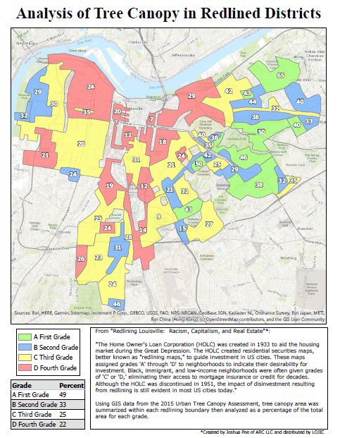
The Louisville/Jefferson County Information Consortium (LOJIC) is a GIS between multiple agencies. It is Louisville's GIS serving the Louisville Metro Area.

Louisville, KY Katılım Eylül 2015
121 Takip Edilen225 Takipçiler
LOJIC retweetledi
Geography Realm
Geography Realm@Geographyrealm·
New GIS job posted: * GIS and Data Instructional Technologist ~ Wellesley, MA USA For information about this and other GIS jobs visit: bit.ly/3aAQFXV
English
0
2
2
0
LOJIC
LOJIC@lojicmaps·
LOJIC is hiring! If you have a strong IT background and GIS knowledge, come work with us. Louisville, KY LOJIC Systems Administrator I/II/III (GIS) (IT Infrastructure Engineer I/II/III) Grade 17/19/21 governmentjobs.com/careers/louisv… @GovernmentJobs
English
0
0
1
0
LOJIC retweetledi
Esri Training
Esri Training@EsriTraining·
Next week: MOOC #5 of 2020 starts. Learn spatial analysis using #ArcGIS Online. Join us! MOOCs are always free & always fun. Sign up at bit.ly/2VYJEKp.
Esri Training tweet media
English
1
18
44
0
LOJIC retweetledi
TreesLouisville
TreesLouisville@treeslouisville·
Here’s our own research on how redlining impacts Tree canopy on a Louisville.
TreesLouisville tweet media
English
0
2
8
0
LOJIC retweetledi
LouMetroHealth
LouMetroHealth@LouMetroHealth·
Have you checked out Louisville's new COVID-19 Dashboard? This new dashboard gives everyone in our community a way to see the current status of COVID-19 cases, deaths, cases by residential ZIP Code... The new dashboard can be viewed at louisvilleky.gov/covid19.
LouMetroHealth tweet media
English
0
5
8
0
LOJIC retweetledi
CARTO
CARTO@CARTO·
This year the Spatial Data Science Conference will be available to our largest audience ever! #SDSC20 will be a free virtual conference taking place between October 19th & 23rd 💥 Find out more in our blog post! hubs.ly/H0stv6C0
English
0
1
9
0
LOJIC
LOJIC@lojicmaps·
Congratulations to Louisville Metro Government on their Esri Special Achievement in GIS award. They certainly deserve this honor. lojic.org/louisville-met…
English
0
0
1
0
LOJIC
LOJIC@lojicmaps·
Explore Map and Data Bundles in the LOJIC Open Data portal data.lojic.org Scroll down to view maps and download the data featured in the maps. #LouisvilleGIS
LOJIC tweet media
English
0
0
3
0
LOJIC retweetledi
Greg Fischer
Greg Fischer@GregFischerLou·
Our Metro GIS team received an ESRI Special Achievement in GIS (SAG) Award for 2020! We really appreciate the hard work put into elevating the usage of GIS in Louisville Metro Government for the benefit of our residents!
English
0
4
21
0
LOJIC retweetledi
Michael Schnuerle
Michael Schnuerle@MichaelMobility·
Here's the Louisville KY area's CO2 emissions per household. Interactive map: #10/38.1745/-85.7517" target="_blank" rel="nofollow noopener">a.tiles.mapbox.com/v3/kamini.gol5… Source: coolclimate.org/maps
Michael Schnuerle tweet media
English
1
2
2
0