Bernie Jenny

196 posts

Bernie Jenny banner
Bernie Jenny

Bernie Jenny

@mappingbernie

Maps and immersive visualisation at Monash University, Melbourne

Melbourne, Australia Katılım Mart 2018
230 Takip Edilen922 Takipçiler
Bernie Jenny retweetledi
Eduard
Eduard@EduardShading·
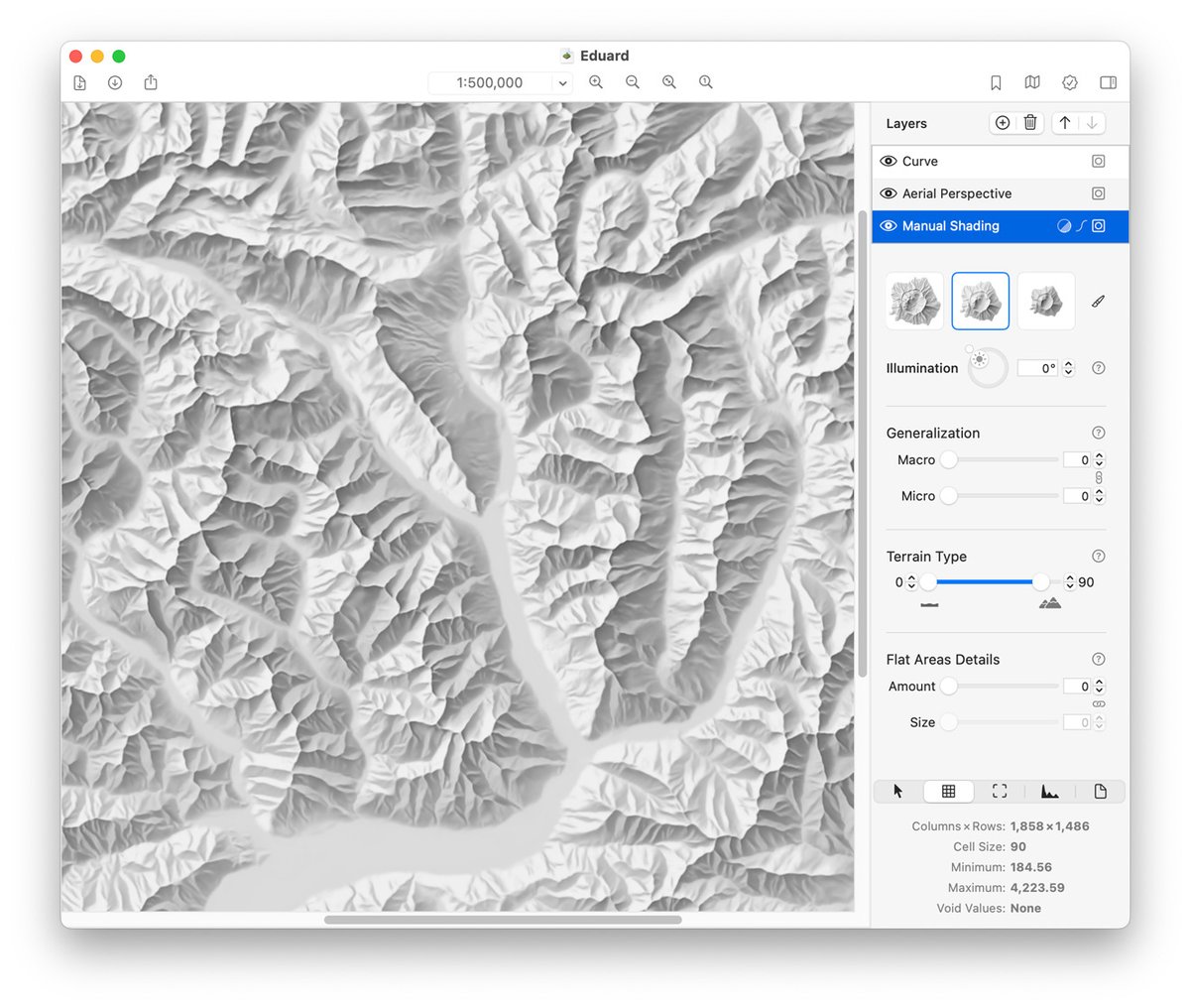
Eduard update 1.4.15 can replace void values with smooth feathering, export grids to small 16-bit GeoTIFF files with decimeter precision, and includes various improvements and bug fixes. eduard.earth
English
0
5
36
3K
Bernie Jenny retweetledi
Eduard
Eduard@EduardShading·
#NACIS special: To celebrate the launch of Eduard Cloud, new accounts get two free Eduard credits. Happy map making!
Eduard tweet media
English
0
4
29
2.4K
Bernie Jenny retweetledi
Eduard
Eduard@EduardShading·
We are thrilled to introduce Eduard Cloud at cloud.eduard.earth High-quality shaded relief for terrain maps can now be created on Windows, macOS, and Linux with any modern browser.
Eduard tweet media
English
3
36
301
18.4K
Bernie Jenny retweetledi
Eduard
Eduard@EduardShading·
Eduard 1.4.14 now supports macOS 26 Tahoe. eduard.earth
Eduard tweet media
English
0
4
8
781
Bernie Jenny retweetledi
Eduard
Eduard@EduardShading·
Eduard 1.4.13 can now download the great new Global Ensemble Digital Terrain Model #GEDTM30 at various resolutions. eduard.earth
Eduard tweet media
English
1
16
131
7.2K
Bernie Jenny retweetledi
Evan Applegate
Evan Applegate@youwillmakemaps·
For beautiful and useful cartographic artifacts check out shadedreliefarchive.com , @MtnMapper and @mappingbernie preserved (and georeferenced!) airbrush/graphite terrain illustrations by artists of the 70s and 80s. Many of the originals were ~3x2 ft. Here are a few by Ellen Kuzdro. "Much of this beautiful art deserves to be used by future mapmakers."
English
0
4
20
3.1K
Bernie Jenny retweetledi
Eduard
Eduard@EduardShading·
Eduard 1.4.12 released: bug fixes and improvements, including a test to make sure elevation model downloads are not too large. eduard.earth
Eduard tweet media
English
3
30
225
15.5K
Bernie Jenny retweetledi
Eduard
Eduard@EduardShading·
Eduard 1.4.9 can now download Copernicus surface and GEBCO bathymetry models. eduard.earth
Eduard tweet media
English
1
3
61
4.5K
Bernie Jenny retweetledi
Eduard
Eduard@EduardShading·
Eduard 1.4.7 adds image masks, improves aerial perspective, and includes bug fixes and improvements. eduard.earth
English
0
3
13
1.1K
Bernie Jenny retweetledi
Tom Patterson
Tom Patterson@MtnMapper·
The Churfirsten DEMs range in resolution from 0.5 to 2,000 meters.
GIF
English
1
2
11
1.1K
Bernie Jenny retweetledi
Tom Patterson
Tom Patterson@MtnMapper·
A manual shaded relief of Churfirsten, Switzerland, by Eduard Imhof. You can try emulating his style digitally with multi-scale DEMs of the same mountain available here: shadedrelief.com/SampleElevatio…
Tom Patterson tweet media
English
2
8
67
4.3K
Bernie Jenny retweetledi
Tom Patterson
Tom Patterson@MtnMapper·
We are preparing new shaded reliefs for Natural Earth v6 with varying amounts of terrain detail. Available soon.
GIF
English
4
15
175
10K
Bernie Jenny retweetledi
mapsdotcom
mapsdotcom@mapsdotcom·
Carbon dioxide (CO2) plays a key role in the presence of life on Earth. It is also a byproduct of industrial activity, and we put more CO2 into the atmosphere than natural processes can remove. Watch a year of CO2 in Earth's atmosphere in this animated, interactive map: maps.com/watch-a-year-i… #maps #dataviz
English
0
7
18
3.1K