Steven Pearce
1.1K posts


@stvnprc He could be driving right through a line of rain/storms/severe weather in the morning
English
@RaleighWx I have a friend that needs to travel by car from Charlotte to Atlanta tomorrow morning. Do you recommend that he leaves at a certain time to avoid the weather or do you think he’ll be OK leaving by 7 AM in the morning?
English

@RaleighWx Funny how things work out. You guys could still hit 6”+ at this rate if things continue at the same pace.
English
The latest HRRR 15 min images show the dry zone from RDU to FAY to ILM closing up by 7:15pm. Then we should see a period of 6-8 hours of snow moderate to heavy at times with 2-4 inches likely in that zone. We shall see.
GIF
English

@stvnprc Wow! That snow is blowing! Nice shot, Steven! Can you confirm where this was filmed? Would you allow WeatherNation to share your video on-air & online, with full credit to you?
English
@stvnprc Hmm interesting question. Cartaret probably, it has a higher ceiling being near the coastal low.
English
@RaleighWx If you could choose to be in Johnston County or Carteret County to see the most snow and have the most fun in the snow, what would be your choice for this storm?
English
@RaleighWx What’s your take on the air mass being shallow such that the dry air won’t be much of an impact on the storm? In other words, dry air 500 mill bars may not be relevant for this set up. Thoughts?
English
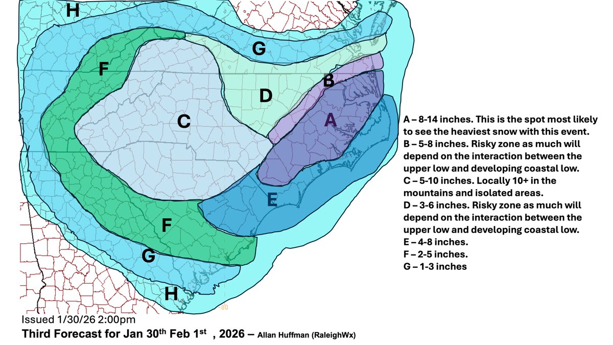
Ok here is my updated forecast, I put out an hour ago based mostly on 12z data. Knowing how this storm is going, I may have to update again!
English
My morning update before the 12z data comes in. and my updated map patreon.com/posts/1-30-26-…

English
@RaleighWx Being a meteorologist forecasting a winter storm in NC has got to the up there on the lists of unenviable jobs.
English
@stvnprc I dont trust any one model. BUt I do start to look at the HRRR, NAM-3km, RFFS, RGEM more closely but still factor in the ECMWF/GFS.
English
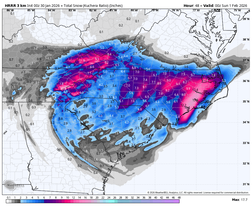
00z HRRR with a pretty snowy run for central/eastern NC and still going at hour 48
GIF
English
@burgwx So is the atmosphere dry at or below where the snow will be produced in the Triangle?
English

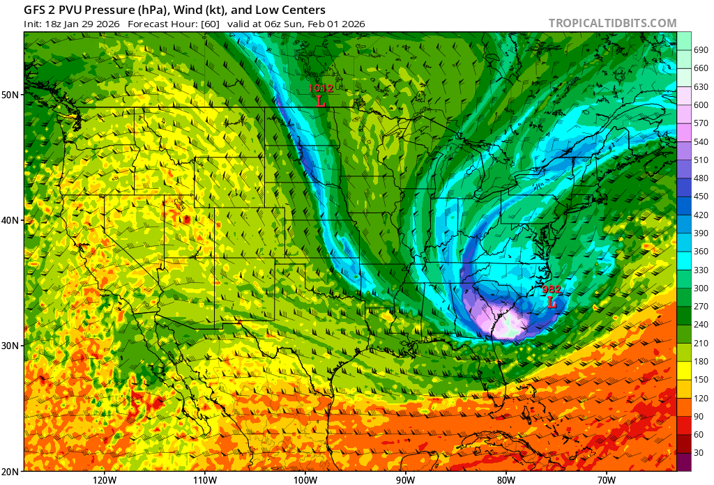
While dry slotting is a legitimate concern in parts of the Carolinas in a corridor between the upper-level low forced cold core precipitation to the south/west & developing coastal low to the east, 500-hPa relative humidity is not a good metric to use here.
The primary driver of this snowstorm is a tropopause polar vortex (TPV) diving down to unusually low latitudes. TPVs are associated with very low tropopauses, and in this case 500mb is actually sampling the tropopause over parts of the Carolinas — meaning the cold-core forced snow is being produced at and falling well below 500mb.
Brad Panovich@wxbrad
One of the tough parts of this forecast for snow totals, and likely why we will see a large variance of totals, are pockest of dry air. I started talking about this yesterday, and this is why I am staying on the low side of most totals. Make no doubt about there are some spots that could go high, especially east towards the coast, but many more that will not have thos high totals. Like forecasting scattered showers or storms, not everyone gets hit the same way. With the 20:1 liquid-to-snow ratios. The difference between 2"-8" of snow is the same difference as 0.05"-0.40" of rainfall. #snOMG #cltwx #ncwx #scwx #wcnc
English
@stvnprc Could be close but I think you may edge up to 33/34. But we shall see.
English
@RaleighWx do you think Kenly (27542) gets above freezing before big slug of precipitation moves through late today?
English