Storm_101
17.6K posts

Storm_101
@tystorm101
Weather Enthusiast. Trained Storm Spotter for NWS Louisville. Makes Weather Predictions. Photographs Weather in my Backyard.
The Bluegrass Region in KY Katılım Şubat 2012
296 Takip Edilen2.5K Takipçiler
@GaudetWeather I'm surprised that we don't have an NBA team. We deserve one.
English


@tystorm101 We talking weak brief spin up for me on the line as it pushes south towards me ?
English
@tystorm101 good morning bro , hope all is well.
How am I looking for tonight on any severe risks concerns and if we talking weak brief spin ups ?
English
@BrutusX4K A Strong Storm or 2 is possible but not really expecting anything Severe. Severe Risk stays north. No Tornado Risk for you as Instability would be very low when the storms arrive tomorrow night.
English
@tystorm101 hey bro good morning. Hope all is well today for you of late.
How am I looking for severe risks concerns tomorrow and any concerns for weak brief spin ups my way on the line ?
English
@BrutusX4K A few Strong Storms will be possible but current trends are the Storms may arrive later which can mean less instability to work with. Hail and Strong Winds are the main threats. The Very Low Tornado Risk would be focused across Northern Ohio. Apologies for the late reply.
English
@tystorm101 hey bro good afternoon, you got any afternoon or new updates on what you seeing for my area for severe risks concerns come Thursday ?
We talking weak brief spin ups on the line too ?
English
@tystorm101 So Thursday favors more hail and wind again you think and maybe weak spin ups ?
Pattern doesn’t support strong stuff correct
English
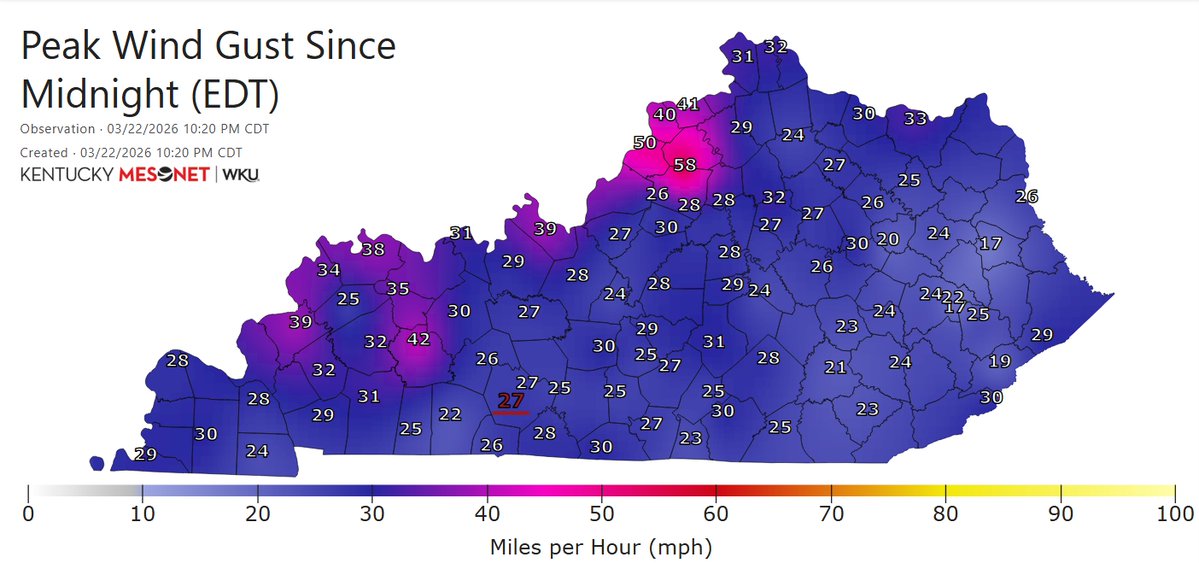
Heads up! A Round of Strong Winds is coming into Central KY along + behind the Cold Front. Wind Gusts will be generally 35-50mph. Though, did have a 58mph Gust out of Shelby County. Strong Storms w/ Hail will come in behind but are expected to weaken as they progress. #kywx

English
Storm_101 retweetledi

English
Storm_101 retweetledi
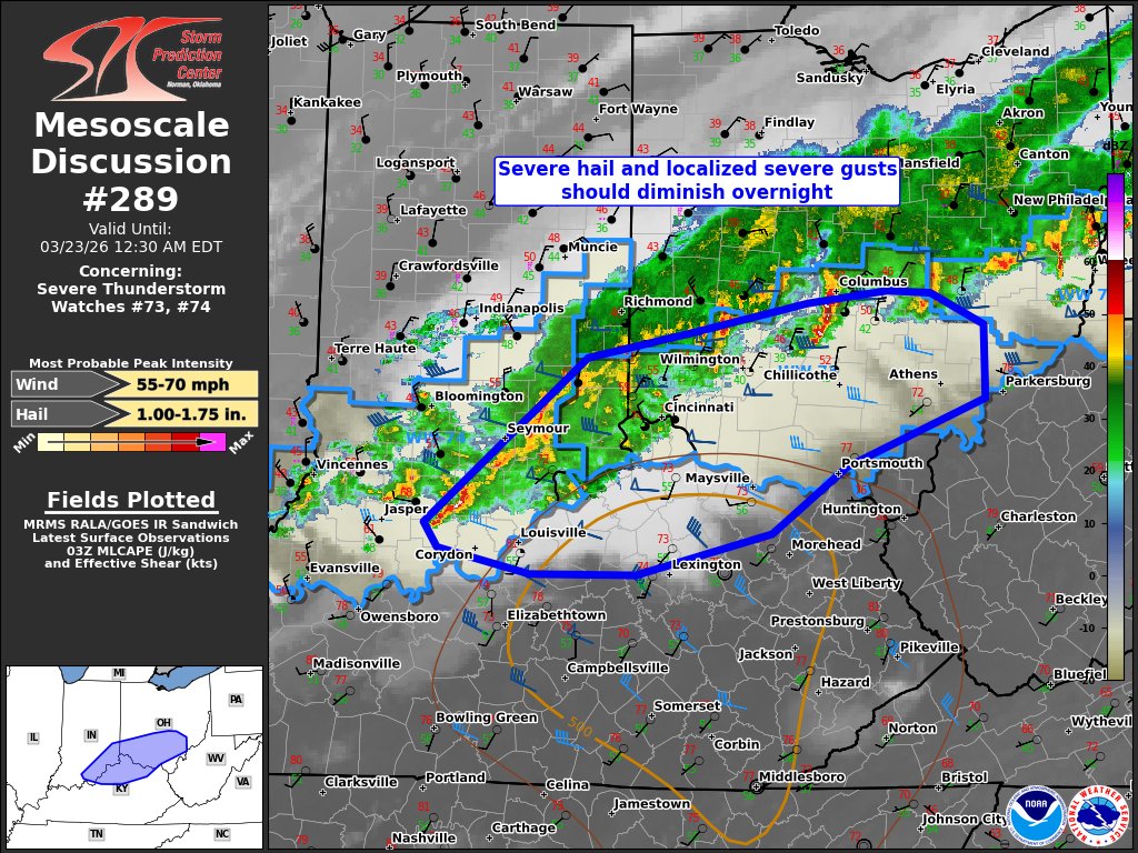
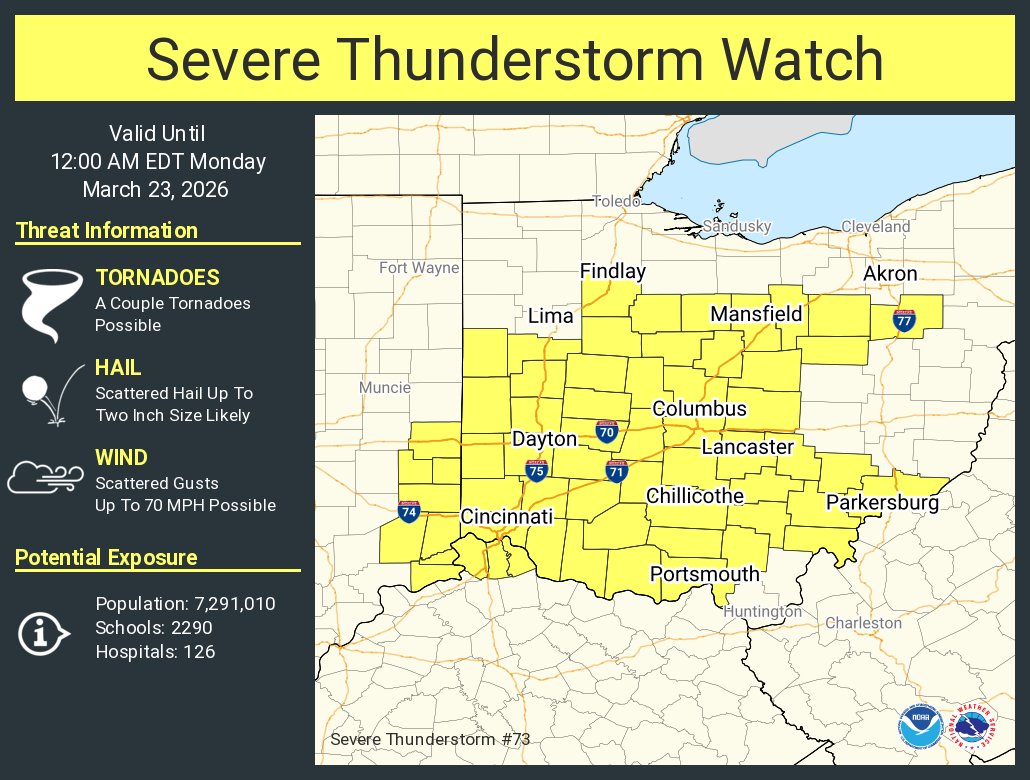
A severe thunderstorm watch has been issued for parts of Illinois, Indiana and Kentucky until 1 AM EDT
English
Storm_101 retweetledi
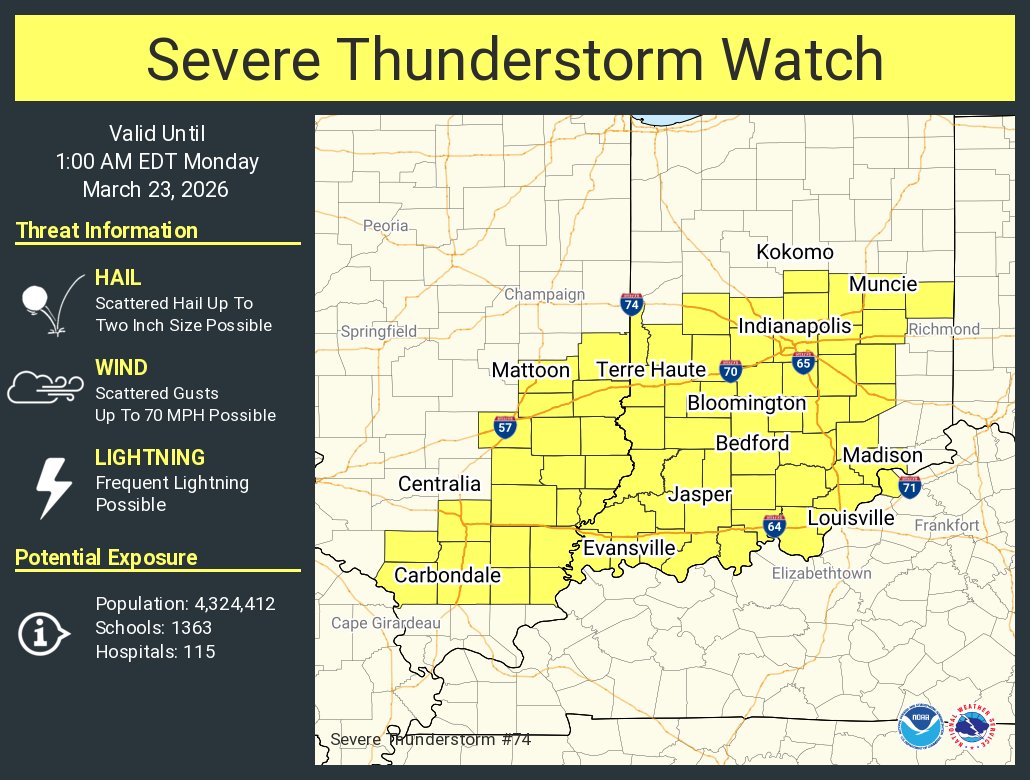
A severe thunderstorm watch has been issued for parts of Indiana, Kentucky and Ohio until 12 AM EDT
English
Storm_101 retweetledi
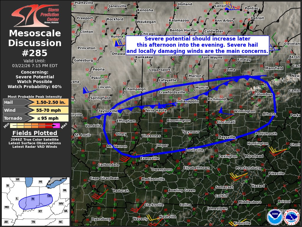
Strong to severe storms are possible tonight in southern Indiana and north central Kentucky. Gusty winds and hail are the main severe threats with storms. Many areas in southern Kentucky will receive little to no rain tonight, and the severe weather is not expected.

English
Storm_101 retweetledi
English
English

Please join us in wishing our Chief Meteorologist @I65WxSils a
HAPPY FREAKING BIRTHDAY!!!🥳
GIF
English
@BrutusX4K The main threat will be Large Hail. Strong to Damaging Winds will be possible. No Tornado Risk given that Low-level shear would be too weak.
English
@tystorm101 hey good morning bro , hope all is well this weekend.
Any new concerns for severe risks or changes ? Seems like it’s wind and hail for me. Looks like the tor risks is well to my east now.
Thoughts ?
English
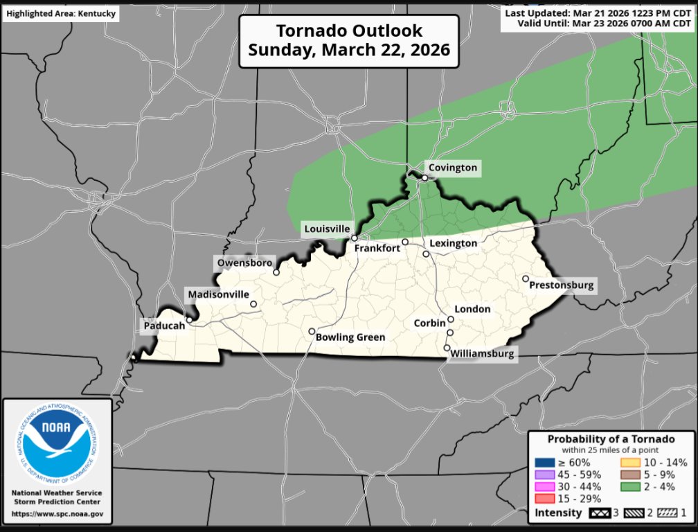
@Xenoturdd9106 There is not a Strong Tornado Risk for this setup. Perhaps up in Pennsylvania if anywhere.
English

@tystorm101 I live in Cincinnati area, is there a chance for a strong tornado? Just worried and wondering
English
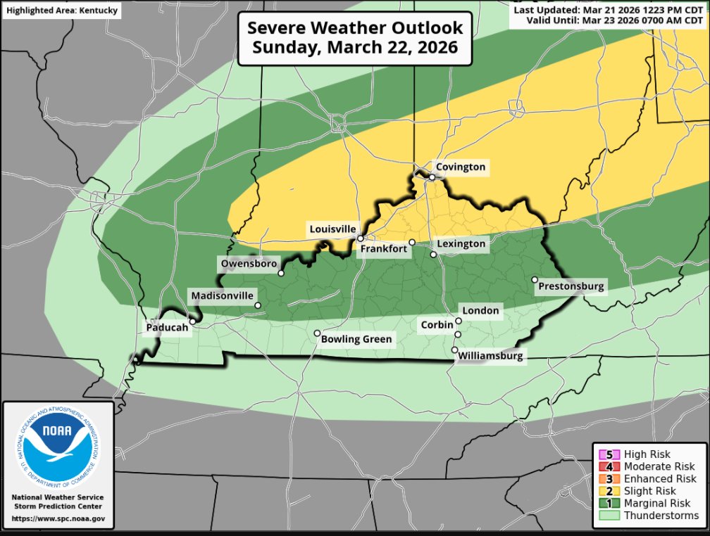
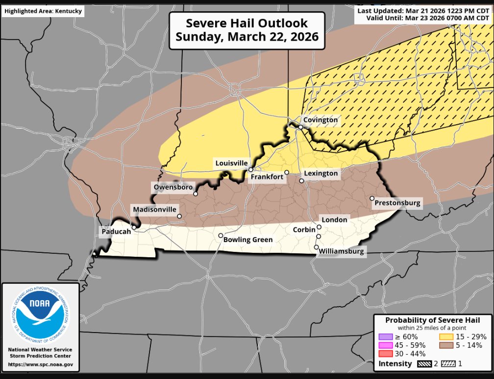
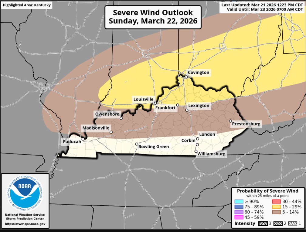
(1/2) I agree with what the SPC shows for Late Tomorrow as a couple of Strong to Severe Storms would be possible generally North of I-64. We'll be capped throughout most of the day but it is expected to weaken later in the evening and that's when we can get some Storms. #kywx
English
@tystorm101 So just wind and hail for me correct bro ?
English
@tystorm101 hey good morning bro , what ya latest thoughts on my area of concerns tomorrow for severe risks ? It seems the 2% is south of me as I’m north of 70 ?
Appreciate you
English
@FutureWXDalton We'll have plenty of Instability to work w/ (generally 1000-1500J/Kg) + Steep Lapse Rates which can lead to Stronger Updrafts within Storms. Also, Wind Shear will be stronger in the Mid-levels (500MB) compared to the Low-levels (850MB) which can lead to an increased risk of Hail.
English

@tystorm101 Can you explain to me why the hail threat is basically the main threat for tomorrow!? Ive been hearing that the hail is the main threat and could be a problem.
English
(2/2) The main hazards would be Large Hail and Damaging Winds. A brief tornado cannot be ruled out with a Supercell but Low-level Shear isn't impressive (especially compared to last Sunday). Storms would weaken as they get to I-64 and points South as we lose instability.
English