VT Emergency Mgmt

3.7K posts

VT Emergency Mgmt banner
VT Emergency Mgmt

VT Emergency Mgmt

@vemvt

VT Emergency Management is a division of the Department of Public Safety. We assist communities with emergency preparedness, response, and recovery.

Waterbury, VT Katılım Mayıs 2009
230 Takip Edilen10.3K Takipçiler
VT Emergency Mgmt retweetledi
NWS Burlington
NWS Burlington@NWSBurlington·
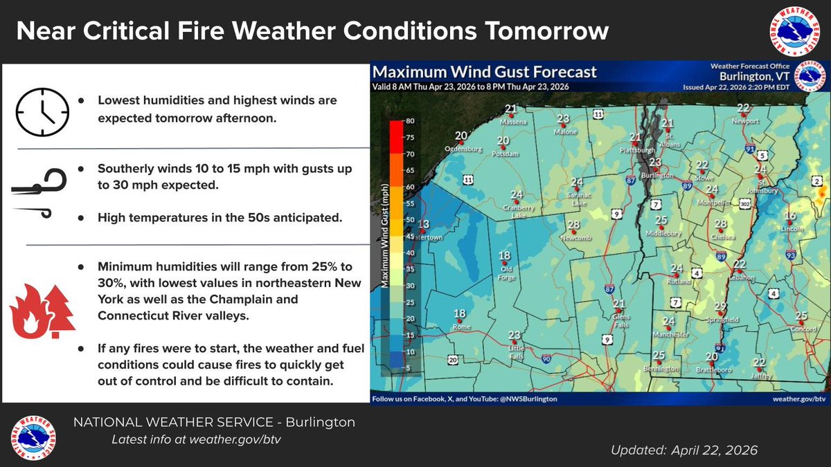
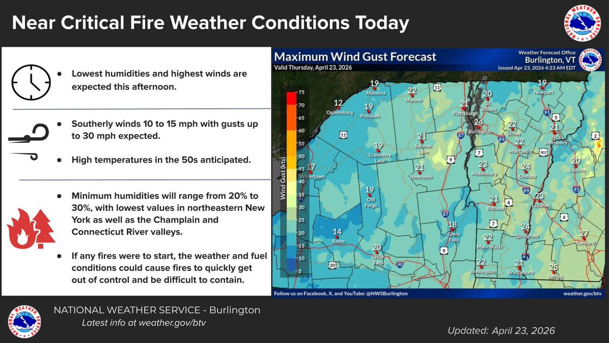
Southerly winds 10-15 mph with gusts up to 30 mph are expected this afternoon with minimum relative humidity values as low as 20-30%. If any fires were to start, the weather and fuel conditions could cause fires to quickly get out of control and be difficult to contain.
NWS Burlington tweet media
English
0
1
3
614
VT Emergency Mgmt retweetledi
NWS Burlington
NWS Burlington@NWSBurlington·
Southerly winds 10-15 mph with gusts up to 30 mph are expected tomorrow afternoon with minimum relative humidity values as low as 25-30%. If any fires were to start, the weather and fuel conditions could cause fires to quickly get out of control and be difficult to contain.
NWS Burlington tweet media
English
0
2
1
830
VT Emergency Mgmt retweetledi
NWS Burlington
NWS Burlington@NWSBurlington·
As part of the 2026 Open Burning Weather Awareness Campaign from the National Weather Service in Burlington, Vermont we will examine ingredients linked to critical fire weather patterns and conditions:
NWS Burlington tweet media
English
0
1
0
535
VT Emergency Mgmt retweetledi
NWS Burlington
NWS Burlington@NWSBurlington·
A severe thunderstorm watch has been issued for parts of Connecticut, Massachusetts, New York, Pennsylvania and Vermont until 10 PM EDT
NWS Burlington tweet media
English
0
1
4
731
VT Emergency Mgmt retweetledi
NWS Burlington
NWS Burlington@NWSBurlington·
The potential for strong to severe thunderstorms remains for this afternoon/early evening. The primary threat will be localized damaging winds, small hail and brief heavy downpours. A brief and weak tornado is also possible over central and southern Vermont.
NWS Burlington tweet media
English
0
1
2
576
VT Emergency Mgmt retweetledi
NWS Burlington
NWS Burlington@NWSBurlington·
All the ingredients are there for very low relative humidity across the region. 1. Pre-green up 2. Full sunlight 3. South to southwest winds A few locations have seen relative humidity fall into the teens with gusts 25 to 35 mph at times, especially near Lake Champlain.
NWS Burlington tweet media
English
0
2
3
596
VT Emergency Mgmt retweetledi
NWS Burlington
NWS Burlington@NWSBurlington·
Near critical fire weather conditions will be present across the St. Lawrence Valley Today. Conditions will be favorable for any fires to quickly spread should any fires start. RHs will be as low as 22 to 28% with gusts up to 30 mph.
IEMBot BTV@iembot_btv

Near Critical Fire Weather Conditions are Expected Today for Northern Franklin, Northern St. Lawrence, Southwestern St. Lawrence [NY] till 6:00 PM EDT mesonet.agron.iastate.edu/p.php?pid=2026…

English
0
2
2
930
VT Emergency Mgmt
VT Emergency Mgmt@vemvt·
VEM is hiring! The Operations Specialist monitors developing incidents, maintains statewide situational awareness, and helps deliver timely public alerts. The deadline for applications is April 6, 2026. careers.vermont.gov/job/Waterbury-…
VT Emergency Mgmt tweet media
English
0
0
0
218
VT Emergency Mgmt retweetledi
NWS Burlington
NWS Burlington@NWSBurlington·
A cold front will bring briefly heavy rain this afternoon into tonight. The front will be stronger across the northern NY with a rumble of thunder possible. Precipitation will weaken and slow as the front approaches VT tonight. Hazards will be heavy rain and strong gusty winds.
NWS Burlington tweet media
English
0
2
4
770
VT Emergency Mgmt
VT Emergency Mgmt@vemvt·
We're hiring! VEM Operations Specialist: support the VEM Watch Desk by monitoring developing incidents, maintaining statewide situational awareness, and helping deliver timely public alerts. careers.vermont.gov/job/Waterbury-…
English
0
0
0
230
VT Emergency Mgmt retweetledi
NWS Burlington
NWS Burlington@NWSBurlington·
🧵(2/4) 💨Strong winds will quickly follow the warm front increasing to possibly 60 mph across portions of northern New York by tonight. Winds will remain strong tomorrow with light freezing rain possible in the sheltered eastern slopes of the areas late tonight.
NWS Burlington tweet mediaNWS Burlington tweet media
English
1
1
1
327
VT Emergency Mgmt retweetledi
NWS Burlington
NWS Burlington@NWSBurlington·
🧵(4/4) ❄️Light snow accumulations are possible, with possible patchy black ice as temperatures fall below freezing by Tuesday morning. Make sure you stay up to date with the latest forecast.
NWS Burlington tweet media
English
0
1
0
683
VT Emergency Mgmt retweetledi
NWS Burlington
NWS Burlington@NWSBurlington·
🧵(3/4) 🌧️A line of showers and possibly thunderstorms is expected by tomorrow night with temperatures quickly falling behind with a switch between rain to snow.
NWS Burlington tweet media
English
1
1
0
748
VT Emergency Mgmt retweetledi
NWS Burlington
NWS Burlington@NWSBurlington·
🧵(1/4) A multi-faceted strong frontal system will approach the area beginning this afternoon with the passage of a weak warm front. ❄️Light snow showers are expected early this afternoon, mainly over the St. Lawrence Valley as the warm lifts north. #VTwx #NYwx
NWS Burlington tweet media
English
1
3
1
1K
VT Emergency Mgmt retweetledi
NWS Burlington
NWS Burlington@NWSBurlington·
Snow will arrive late this afternoon and evening, with briefly heavier snow a couple hours after the first flakes fall. Terrain influences will result in more snow for the Adirondacks and high elevations of Vermont. Slick travel is possible tonight with lingering snow, Saturday.
NWS Burlington tweet media
English
0
3
5
1K
VT Emergency Mgmt retweetledi
NWS Albany
NWS Albany@NWSAlbany·
Rain will change to a wintry mix of freezing rain & sleet tonight. There's a 20-40% chance of at least 0.10" flat ice in lower elevations & a 50-80% chance in higher elevations. There's a 20-60% chance of > 0.25" flat ice in higher elevations. Untreated surfaces will become icy.
NWS Albany tweet mediaNWS Albany tweet mediaNWS Albany tweet media
English
0
4
24
2.4K
VT Emergency Mgmt retweetledi
NWS Burlington
NWS Burlington@NWSBurlington·
Ice accumulations of up to 0.10” across the St Lawrence Valley and parts of central-southern Vt. Snow and sleet accumulation of a dusting to 2 inches possible. Heaviest precipitation occurs between 7 PM this evening and 7 AM Friday. Localized hazardous travel is expected.
NWS Burlington tweet media
English
0
3
3
1.1K
VT Emergency Mgmt retweetledi
MEMA
MEMA@MassEMA·
At the direction of @MassGovernor, MEMA has requested out-of-state mutual aid to help support snow removal operations. This morning, snow removal crews and equipment arrived from Vermont. We’re grateful for our strong regional partnerships and their swift support.
MEMA tweet mediaMEMA tweet media
English
10
28
166
8.8K
VT Emergency Mgmt retweetledi
Vermont Agency of Transportation
This morning, AOT sent a convoy down to Massachusetts to assist with snow removal. The group consisted of 32 employees from throughout the state, included managers and supervisors, and was escorted by DMV Enforcement. (1/2)
English
0
1
6
380
VT Emergency Mgmt retweetledi
Vermont Agency of Transportation
Our team took 12 full-sized orange plow trucks, 12 bucket loaders, 7 pick-up trucks equipped with plows, a half-ton pickup, a van, and two maintenance mechanic vehicles. We are always glad to help our neighbors. That is the Vermont way! (2/2) youtube.com/shorts/Bl84vwr…
YouTube video
YouTube
English
0
2
6
563