EstesParkWx

1.2K posts

EstesParkWx banner
EstesParkWx

EstesParkWx

@weatherelated

Exploring the intersections of weather, forest ecology, and topographic relief. Recording and reporting notable weather events in Estes Park, CO.

Estes Park, CO Katılım Kasım 2018
98 Takip Edilen492 Takipçiler
EstesParkWx
EstesParkWx@weatherelated·
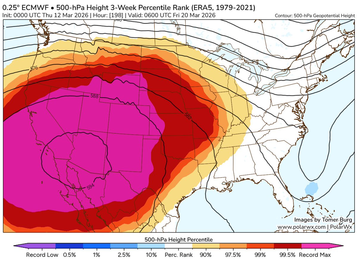
@BoulderCAST Just praying the early April troughing sticks around in the forecast (if it’s even still there this morning… :/)
English
0
0
0
34
BoulderCAST Weather 🏔️⛈️
Boulder Heatwave records broken so far: 2 Daily Record Warm Minimums 4 Daily Record Highs 1 Monthly Record High Earliest 85° day Longest 80° streak in March Still to come: 2 Daily Record Highs (Guaranteed, March 24th / March 25th) 2 Daily Record Highs (Possible, March 23rd and March 26th) Earliest 90° Day (Low Chance, March 26th) 1 to 3 Daily Record Warm Minimums (Likely, March 22nd-March 25th) #COwx #Colorado #Boulder #Heatwave
BoulderCAST Weather 🏔️⛈️ tweet media
English
2
2
13
1.1K
EstesParkWx
EstesParkWx@weatherelated·
We hit 75 degrees today at almost 8000’ on the west side of Estes Park. The alltime March record (before the last few days) was previously 70F on 3/31/1925 @NWSBoulder #cowx
English
0
0
1
208
BoulderCAST Weather 🏔️⛈️
Throw back to this day TWO years ago. Waking up to 2 to 4 FEET of snow in Boulder County was bliss. Officially 22" in Boulder and ~3.5" of liquid! This remains one of the most fun Front Range snow storms we have forecasted in the last 15 years: bouldercast.com/winter-storm-r… #COWx
BoulderCAST Weather 🏔️⛈️ tweet media
English
5
1
36
1.9K
EstesParkWx
EstesParkWx@weatherelated·
the heatwave version of “what if it was all snow” is what if this heat dome was around the summer solstice 😂
English
0
0
2
107
EstesParkWx
EstesParkWx@weatherelated·
🌡️ Next weekend has historic heatwave potential for March across the SW. 🥵 FOR ESTES PARK: 70F in March is the record high (3/31/1925)! Likely this gets tied or broken. Warmest March low of 47 on 3/31/1978 looks like it could be under threat as well. #cowx
English
0
0
0
185
EstesParkWx
EstesParkWx@weatherelated·
Actually snowing pretty good in Estes Park! 29 degrees and 0.25” on most non-paved surfaces @NWSBoulder #cowx
EstesParkWx tweet media
English
0
0
3
124
EstesParkWx
EstesParkWx@weatherelated·
12” of snow and still going at about 7850’ in Westes (near Beaver Meadows VC)! @NWSBoulder #cowx
EstesParkWx tweet media
English
0
0
2
176
EstesParkWx
EstesParkWx@weatherelated·
@BoulderCAST Actually 12” in Westes by Beaver Meadows VC. the 5” report i saw earlier was a severe undercount
English
0
0
0
21
BoulderCAST Weather 🏔️⛈️
SNOW UPDATE! ❄️📈 As we alluded to last night, we're now looking at a stronger, slower storm with higher snow totals, slushier roads down low, and heavy snow in the Foothills/Mtns with difficult travel there. Good news all around for the drought-stricken Front Range! 💦 #COwx
BoulderCAST Weather 🏔️⛈️ tweet media
English
4
2
74
5.3K
EstesParkWx
EstesParkWx@weatherelated·
@BoulderCAST You might be right about a localized very heavy band. Getting reports from eastern Estes and western Estes that are closer to 6”. Honestly i’m ok missing it if i’m gonna get fomo from a mile away lol
English
1
0
1
24
EstesParkWx
EstesParkWx@weatherelated·
@BoulderCAST Good to know! Yea looks like rates are calming down but seems like most in town should wind up with close to a foot
English
1
0
1
26
BoulderCAST Weather 🏔️⛈️
@weatherelated Crazy you're missing it! Thanks for the reports. Seems like Estes got a nasty stationary band of heavy snow overnight. The best snows are probably in the past up there though.
English
1
0
1
108
EstesParkWx
EstesParkWx@weatherelated·
@NWSBoulder LA1001 - trying to obtain a report from around my house (Westes) as well. 10” would appear to be conservative as other pics in the area easily show a foot. Here’s someone’s driveway:
EstesParkWx tweet media
English
0
0
3
275
EstesParkWx
EstesParkWx@weatherelated·
About 9.75” of snow and still dumping hard at about 7800’ on Prospect Mountain in Estes Park! @NWSBoulder #cowx
EstesParkWx tweet media
English
2
1
26
4K
Kody Wilson
Kody Wilson@kodythewxguy·
Good mernin and happy Friday you adorable little chicken nuggets. Our storm system is underway storm systeming. 😜 Mountain snow, rain/snow showers on the western slope, snow in southern Wyoming. Precipitation is blossoming across the foothills, front range and I-25 corridor with embedded thunderstorms as low pressure deepens. Keeping my snurfall accumulation probabilities unchanged. The biggest question is how much accumulates below 6000 feet due to the recent warm temperatures and higher sun angle. In full honesty and transparency, I would not be surprised if snur totals exceeded expectations across the northern front range and in the foothills west of I-25 especially in Jefferson, Boulder, and Larimer County going onto the Cheyenne Ridge. Especially given the recent convective trends. Just gonna let this baby go and see what happens! Nonetheless, it's going to be a spicy day. Expect areas of rain, and thunderstorms to quickly change over to snow as colder air advects down to the surface expanding south into southern Colorado and east onto the plains throughout the morning and afternoon. To check road conditions and webcams: Wyoming: wyoroad.info Colorado: cotrip.org Nebrasky: 511.nebraska.gov Heaviest precipitation will occur during a 3-6 hour window as this convection develops and expands. After that, snow will lighten up as we head later into the afternoon. Once the heaviest precipitation winds down, northerly downsloping winds will be strong enough to shut precipitation off across the northern front range in Larimer, Weld, and Morgan County. On the far SE plains and SW Kansas in the warm sector, just rain showers, some drizzle and then afternoon thunderstorms as the cold front moves through from north to south. Another tricky area for sneaky snurfall accumulation will be across the far NE plains north of I-76 going up in to the Nebrasky Pandyhandle closer to where the storm is expected to track. You can consult my handy dandy graphics for my forecast probabilities. I'll be nowcasting throughout the day. Any lingering snow in the southern mountains should diminish going into Saturday morning setting us up for a dry weekend with moderating temperatures. Stay tuned! Which country's capital is the fastest growing? Ireland. Every year it's Dublin. 🤣😜😂😁😆🤣😜😂 Don't delete me. So thankful to Z Plumberz of Southwest Denver (my exclusive plumbing sponsor in the Denver metro), Rocky Mountain Exteriors (my exclusive painting sponsor in the Denver metro), Tumbarello Insulation (my insulation installation and removal experts based in El Paso County), and to Get Moving LLC (a great Northern Colorado based moving company that has sponsored me for years). Thank you for sponsoring this update and for your support of my page. PLEASE SUPPORT LOCAL! To learn more, visit kodythewxguy.com/colorado-spons… for more information. K great thanks bye!ur
Kody Wilson tweet mediaKody Wilson tweet mediaKody Wilson tweet media
English
2
8
94
3.9K
EstesParkWx
EstesParkWx@weatherelated·
Some high spring snow rates to start off the day here in Estes Park! 0.5” on elevated surfaces so far. Temp of 30F. @NWSBoulder #cowx -LA1001
English
0
0
4
169