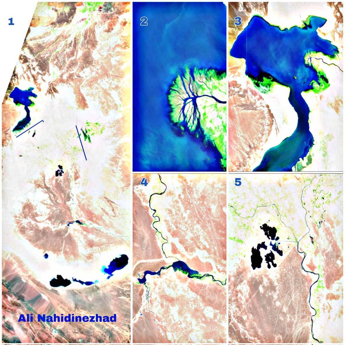
Amir

3.5K posts

Amir banner
Amir

Amir

@x4rius

Just having a fair dinkum go at life 🌴 🇦🇺 Doing lots of cool stuff at @soaratlas, Detail and IREX (👽)

San Francisco, CA Katılım Temmuz 2017
1.1K Takip Edilen1K Takipçiler
Emiliano Kargieman
Emiliano Kargieman@earlkman·
An overnight EO revolution 15 years in the making :) I'm very proud and excited to share the launch of Merlin, remapping the Earth every day, at 1m resolution: the scale of human activity. This new capability will allow us to deliver continuous intelligence globally. Read more!
Satellogic@Satellogic

Fifteen years ago, we asked a simple question: what if we could build a living map of the Earth? Today, with Merlin, we’re taking a major step toward that vision, remapping the entire planet daily at 1 m resolution. The question is no longer “Can I get an image?” It’s “What changed today?” That shift will define the future of Earth observation. More here: satellogic.com/2026/03/18/int…

English
9
20
152
23.7K
Amir
Amir@x4rius·
Meet the 3 tiny islands that could be taken first by US troops: Abu Musa, Greater Tunb, and Lesser Tunb. These islands are incredibly strategic—and are barely talked about. They sit right beside the entrance of the Strait of Hormuz. @SoarAtlas map link: tinyurl.com/ycmvvhzn
Amir tweet media
English
2
11
36
14K
Amir retweetledi
Soar
Soar@SoarAtlas·
🚨Soar Atlas has obtained new high-resolution satellite imagery from March 15th confirming the legitimacy of the much debated strikes at the Al Dhafra Air Base in UAE. Explore & compare here: tinyurl.com/4jsmynb5 Impacts at the accommodation area and nearby buildings.
Soar tweet mediaSoar tweet mediaSoar tweet mediaSoar tweet media
English
11
182
779
133.9K
Amir
Amir@x4rius·
Radar imagery is awesome. It can see through clouds. Lots of cloud over Persian Gulf lately (its a spring thing) but managed to see the tanker 'waiting' areas off the coasts of UAE and the Straits of Hormuz with this imagery from @SoarAtlas
Amir tweet mediaAmir tweet mediaAmir tweet mediaAmir tweet media
English
0
0
1
206
Amir
Amir@x4rius·
@sekopss Great job James. Happy to host these for you on @SoarAtlas so you can get more exposure. Keep up the great work 👏
English
0
0
0
53
James Spokes
James Spokes@sekopss·
Automatically georeferenced 381 Soviet military topographic maps of China into a seamless mosaic over satellite imagery.
English
5
23
232
17.1K
Amir
Amir@x4rius·
@SoarAtlas Still havent seen any evidence of Iran having a working ADS 😆
English
0
0
0
286
Tony De La Rosa
Tony De La Rosa@T_De_La_Rosa·
@SoarAtlas I know you're busy, but did you ever imagine your newly created site would be so important in this conflict, after its previous use as an environment or a public works comparison service? Keep it up, the work you're doing is much more than the news media is able to give. Tony
English
2
1
5
332
Soar
Soar@SoarAtlas·
🛩️Satellite imagery from March 6th confirms two Su-22 aircrafts were destroyed at the Shiraz Shahid Dastgheib International Airport in Iran. Use the slider to compare here: tinyurl.com/bdfffcw5 #Airport #IranIsraelUSWar #Iran
English
2
10
84
8.6K
Amir
Amir@x4rius·
Soar@SoarAtlas

As conflicts break out, AI-generated fake imagery is becoming more common online. At Soar Atlas, we manually review every satellite image and map that comes through our system to ensure uploads remain trustworthy. One image currently circulating shows an air base with planes painted on the ground. While it may look convincing at first glance, there are a few clues that suggest it isn’t real satellite imagery. First, most commercial satellites, such as those operated by Maxar Technologies or Planet Labs, capture imagery at roughly 30cm per pixel. Because of this physical limitation, extremely fine details usually aren’t visible from space. If an image appears unusually sharp or shows very small features with perfect clarity, it’s worth questioning. Satellites don’t capture imagery the way it’s often portrayed in movies. They aren’t constantly watching every location with a live camera in the sky. Most Earth-observation satellites travel in fixed orbits and only pass over the same area at certain times, which means many major events are not captured immediately and may only be imaged hours or even days later depending on when the next pass occurs. Weather is another major limitation. Cloud cover frequently blocks optical satellite imagery, making it difficult to capture clear views of the ground. While some satellites use radar to see through clouds, these systems produce radar imagery rather than traditional photograph looking imagery, which can be harder for the public to interpret visually. It’s also important to look for a source. Authentic satellite imagery is almost always credited to the provider, often through a watermark or attribution. If there’s no source attached, that’s a warning sign. Another useful check is whether the imagery is georeferenced. When imagery is properly placed over real-world maps, such as those on Soar Atlas, it becomes much easier to verify whether features actually line up with the surrounding environment. AI will often get these kinds of details wrong. Finally, keep an eye out for AI tool marks or watermarks, such as the small star symbol added by Gemini in the corner. Every image on soaratlas.com we've verified. If you think something doesn't look right, click the three dots and report the map or ping us! As AI tools improve, spotting fakes will become harder. During this conflict we’ve unfortunately come across many examples, so it’s important to stay cautious and take a moment to question images before sharing them.

English
1
5
43
18.8K
Amir retweetledi
Soar
Soar@SoarAtlas·
As conflicts break out, AI-generated fake imagery is becoming more common online. At Soar Atlas, we manually review every satellite image and map that comes through our system to ensure uploads remain trustworthy. One image currently circulating shows an air base with planes painted on the ground. While it may look convincing at first glance, there are a few clues that suggest it isn’t real satellite imagery. First, most commercial satellites, such as those operated by Maxar Technologies or Planet Labs, capture imagery at roughly 30cm per pixel. Because of this physical limitation, extremely fine details usually aren’t visible from space. If an image appears unusually sharp or shows very small features with perfect clarity, it’s worth questioning. Satellites don’t capture imagery the way it’s often portrayed in movies. They aren’t constantly watching every location with a live camera in the sky. Most Earth-observation satellites travel in fixed orbits and only pass over the same area at certain times, which means many major events are not captured immediately and may only be imaged hours or even days later depending on when the next pass occurs. Weather is another major limitation. Cloud cover frequently blocks optical satellite imagery, making it difficult to capture clear views of the ground. While some satellites use radar to see through clouds, these systems produce radar imagery rather than traditional photograph looking imagery, which can be harder for the public to interpret visually. It’s also important to look for a source. Authentic satellite imagery is almost always credited to the provider, often through a watermark or attribution. If there’s no source attached, that’s a warning sign. Another useful check is whether the imagery is georeferenced. When imagery is properly placed over real-world maps, such as those on Soar Atlas, it becomes much easier to verify whether features actually line up with the surrounding environment. AI will often get these kinds of details wrong. Finally, keep an eye out for AI tool marks or watermarks, such as the small star symbol added by Gemini in the corner. Every image on soaratlas.com we've verified. If you think something doesn't look right, click the three dots and report the map or ping us! As AI tools improve, spotting fakes will become harder. During this conflict we’ve unfortunately come across many examples, so it’s important to stay cautious and take a moment to question images before sharing them.
Soar tweet media
English
10
74
361
67.6K
Amir
Amir@x4rius·
Searching a war zone for latest Sentinel imagery on @SoarAtlas Every. Single. Time! Clouds damn it. Clouds!! CC: @mouthofmorrison 😅 any SAR images floating around you care to upload? 😉
Amir tweet media
English
0
1
7
755
Amir
Amir@x4rius·
@ricwe123 Get your facts right Richard. Iranians are arguably the best engineers in the world. Ive worked with some and its almost like they have a genetic tether to maths and physics. Incredible brains.
English
0
0
2
48
Richard
Richard@ricwe123·
Israeli experts are now sounding the alarm: Iranian cluster missiles can split into as many as 80 sub-missiles, hitting multiple targets simultaneously. They’re calling it an unprecedented weapon. The bigger question: how did Iran even get its hands on such technology in a country where scientists are constantly being assassinated? It’s hard to ignore the possibility that China and Russia handed this deadly know-how straight to Tehran.
English
4.6K
6.6K
28.3K
3.7M