415FirePhoto รีทวีตแล้ว

Bridges to nowhere.
Trains to nowhere.
Leave the building to us, @GavinNewsom
End Wokeness@EndWokeness
California already spent $114 million on this unfinished wildlife crossing bridge (leading nowhere)
English
415FirePhoto
10.9K posts

@415FirePhoto
Alex “Trey” Robertson - Plaintiffs' Co-Liaison Attorney in Palisades Fire/Volunteer Firefighter/Fire photographer👇 IG | https://t.co/mdr9D1CPRk?
California already spent $114 million on this unfinished wildlife crossing bridge (leading nowhere)
Ridiculous CA Wildlife Bridge Aims to Prevent Inbred Mountain Lions, but Will Be a Wildfire Express Lane redstate.com/jenvanlaar/202…

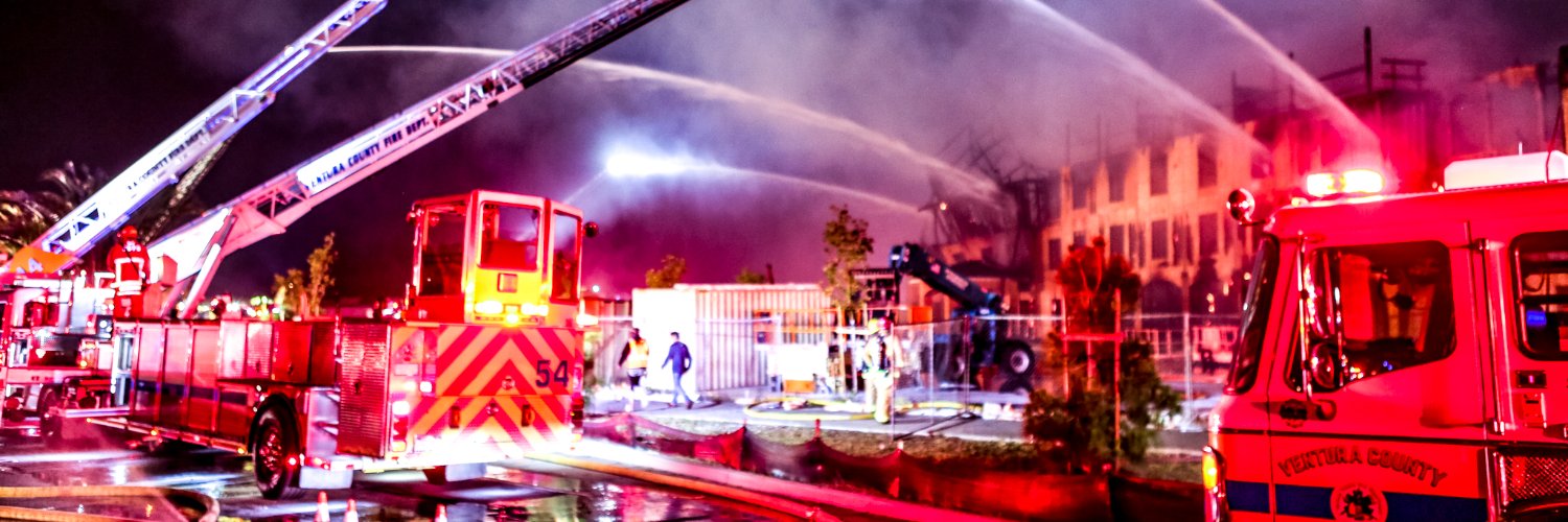
This is the common retort from people who don't understand what firebreaks do, so let's dismantle this once and for all. This is like saying "well, seatbelts don't save you when you get hit head on by a semi going 70mph, therefore seatbelts don't work and they're meaningless." Yes, under the WORST possible conditions, seatbelts won't save your life and and under the worst conditions, wildfires will jump firebreaks. But not every fire starts or spreads into bad spots under the worst possible conditions. Not every wildfire spots 3 miles ahead of itself. You don't just give up on using this tried and true tactic and surrender to EVERY single wildfire that may occur. Furthermore, these people don't understand what firebreaks actually do. A firebreak sometimes stops the fire. But a firebreak ALWAYS converts a raging head fire into a spot fire. It converts something you CAN'T stop into something you have a chance to stop. Additionally, a firebreak isn't always meant to stop the fire, but be an anchor point for a firing operation ahead of the flaming front. During a wildfire, hand crews and dozers have to work quickly to construct these lines so they can fire off ahead of the front and have a larger buffer that CAN mitigate the long range spotting. Firefighters are always racing against time. That's why they use retardant...not to stop the fire, but to retard the progress of it, to buy time to get line constructed, and firing operations executed. If you have pre-attack lines already in place, resources can just immediately anchor in and get to work. Furthermore, spotting potential decreases logarithmically with distance. Not every ember is capable of carrying heat residency across 3 miles. Most embers fizzle out within seconds. Therefore, the closer the next receptive fuel bed, the exponentially higher odds of the fire spotting multiple times. A short range spot is exponentially more likely than a long range spot. By establishing a 300 foot fuel break, you increase your odds of protecting what's on the other side, by orders of magnitude. And wind-driven fires spot in ONE direction. You don't get 3 mile spotting on the flanks. While a fuel break may not stop the head of the fire, it often will stop the flanks...and given how most fires get wind swaps in the overnight hours, those buttoned up flanks could've become raging head fire later. Here is an example from when I was in the middle of the freeway on the Easy Fire in 2019. As you can see, NOTHING was stopping this head fire. No amount of hoses, deck guns, nothing. And the fire did spot across the freeway, but they picked it up almost immediately and buttoned up the fire. The freeway didn't stop the fire...it just converted head fire into a more manageable spot fire. I'm tired of everyone making excuses for not doing firebreaks. There's not a single person in wildland fire who thinks they don't work. The only people who think they don't work are people who don't understand how they work.
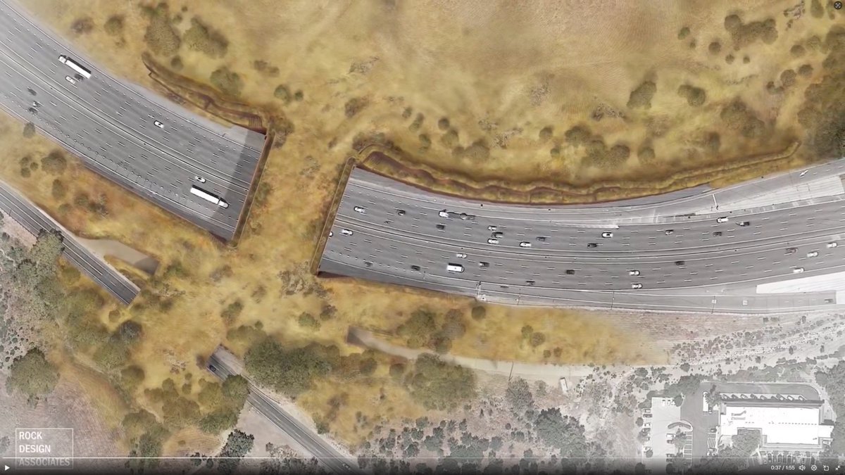
NEW: California's wildlife crossing bridge is $21 million over budget, a year late, and still not complete. The project began in 2022 and, according to City Journal, the price tag on the project is now $114 million. The bridge was built so animals like butterflies can use it, according to Wallis Annenberg Wildlife Crossing leader Beth Pratt. Pratt claims the $21 million overage is due to inflation, tariffs, and labor problems. Insane.

Here are all of the current posted @NWS hazards in California. Most of the state's population is under a Heat Advisory (orange), and or an Extreme Heat Watch/ Warning (red and pink). California has never this many heat advisories and or warnings in the month of March. #CAwx
Extreme heat looking likely for #SoCal next week: - MAJOR to EXTREME HEAT RISK likely next Tue-Thu - High temperatures in the 90s to low 100s - Very warm overnight low temperatures - Daily and monthly temperature records at risk Prepare now for this upcoming heat event. #CAwx


Notice how often you see “Topanga” in this list of historic wildfires? Probably nothing.
Followers - I’m officially declaring Winter over for the Western U.S. Before diving into the analysis, I want to address something I hear quite a bit. A lot of people say my posts sound negative. Some of you think I’m constantly calling out bad patterns or dry conditions just to be pessimistic. The reality is that’s not the mission here. I’m not here for clicks, fantasy weather p*rn patterns, engagement farming, or viral posts. Folks - That is what most of X is. I’m not trying to build hype or push narratives that the atmosphere simply doesn’t support. A lot of others do that, but I don't. My goal has always been the same: look at the data, study the pattern, and share what I’m seeing in the trends, with honestly and transparently. Sometimes that means calling out great storm setups. Sometimes it means highlighting drought risks or weak patterns. But the mission is simple: educate, analyze, and discuss the weather as it actually is, not as we wish it would be. Many of you appreciate that, some of you don't, even if the message isn’t always what people want to hear. As you know I have gotten hate mail the last few weeks because I didn't forecast an AR this past week in #socal, so I want to set the record straight. Instead, we got 90+ degree weather and moderate to strong Santa Ana winds. And guess what, that pattern will continue off and on thru the next few weeks. Now to the pattern and to why I think winter is done out west. Here along the Southern California coast we’ve seen 90°+ temperatures in Santa Monica and most of #Socal along the coast over the last few days, paired with 20–40 MPH Santa Ana winds, very low humidity, and an increasingly dry boundary layer. For early March, that combination is a pretty strong signal that the seasonal transition has already taken place. From a synoptic standpoint, this winter was extremely challenging. A major factor was how Rossby wave propagation across the Pacific was repeatedly disrupted by polar vortex dynamics, setting up the meridional flow along the west coast. Instead of a stable Pacific jet delivering consistent storm energy into California, the wave train was frequently altered by vortex perturbations, which displaced energy eastward and disrupted the normal storm track. The result across the West: • Persistent West Coast ridging • Storm spacing often exceeding 35+ days • Systems frequently splitting or diving toward Baja • Warmer Pacific air masses elevating Sierra snow levels So while storms did arrive, they were episodic rather than sustained, creating a very stop-and-go winter across California. Meanwhile, the polar vortex is forecast to stretch again next week, allowing colder air to drop into the Northeast and bringing another late-season winter push back east. Folks, this has been the theme the whole winter, as it continues to happen again. Today is 65 degrees in NY. They might be around Freezing in about 8+ days time once again, with a few more opportunities for snow. You can't make it up. Looking at how my Winter Outlook verified (Nov–Mar): • Downtown Los Angeles rainfall: Finished within my projected range, despite the large dry gaps between storms. Could they get shower or two at the end of the month into April. It is possible, but it will be weak, as the wavelengths are transitioning from winter to spring, and the jet is weaker. Plus the pattern setup doesn't really dictate it. • Central Park snowfall: Also within range, thanks to a few well-timed events in the Northeast with a few nor-easters and a PVs to boot. • Sierra Nevada snowfall: This is where I missed significantly. I expected a stronger snowpack season, but totals have lagged badly. At the current pace, many Sierra locations may struggle to even reach ~300" this season, which is well below expectations. Is it possible to get more snow at the end of the month....Yes, but folks it ain't going to make a difference at that point. Sustained warmth, and dry conditions will be the kill shot for the mountain resorts. The combination of persistent ridging, disrupted Rossby waves, marginal thermodynamics, and poorly timed storm tracks ultimately capped Sierra snowfall potential. Looking forward, ensemble guidance continues to show ridging rebuilding along the West Coast, reinforcing a dry regime for California. I’ll post model panels and ensemble data below that highlight the evolving pattern. Another storyline to watch: there’s growing chatter in the climate community about the possible return of El Niño later this year. Subsurface Pacific signals and early model guidance are starting to hint in that direction, and the discussion around it has become very active recently. Everyone is jumping onto this solution in the uber long range models, but time will tell. I hope it happens, as this pattern blows out west. TBC! One final note. I’ve got some business in NorCal this week, so I’ll be heading up there before swinging over to @palisadestahoe. On paper, the resort sits just shy of 300" total snowfall, but after that 100" dump over Presidents’ Week, the atmospheric rivers brought heavy rain at the end of February, and basically decimated the snowpack in certain areas. This, folks, combined with the above average temps, has been the story up and down the West Coast this season. Looking at the forecast, it’s going to be sunny and hitting 65° every day in tahoe when I am there. It is what it is. After this trip, I’ve got another one booked to @Deer_Valley at the end of the month, but with these temps and dry conditions, I’m not sure there will be much snow to make the trip worth it. Honestly, snow conditions out west have been brutal this season.... just look at Utah, Colorado, and now California. Meanwhile, Downtown LA might hit 100+° either Thursday or Friday this week, and the following week…so yeah, winter is officially over, except back east, as the PV is coming back, as I mentioned before. I guess Phil was right all along! Wish I had better news. Note - If this sustained heat dome pattern with santa ana winds in #socal continues, fires will be the next shoe to drop. Something to watch out for in the upcoming weeks and months.!! More updates coming this week!!! #CAwx #Weather #SantaAnaWinds #CaliforniaDrought #SierraSnow #ElNino #PolarVortex #ClimateTrends #Winter2026 #StormPatterns #RossbyWaves #WestCoastWeather #ClimateScience #DryCalifornia #HeatWave #EarlySummer #Snowpack #WeatherOutlook #california #PolarVortex