IowaWeather.com

11.2K posts

IowaWeather.com banner
IowaWeather.com

IowaWeather.com

@IAStormChasing

The largest online Iowa weather network. Bringing you the best weather coverage devoted only to online viewers. #iawx

Iowa เข้าร่วม Nisan 2010
2.7K กำลังติดตาม24.6K ผู้ติดตาม
IowaWeather.com
IowaWeather.com@IAStormChasing·
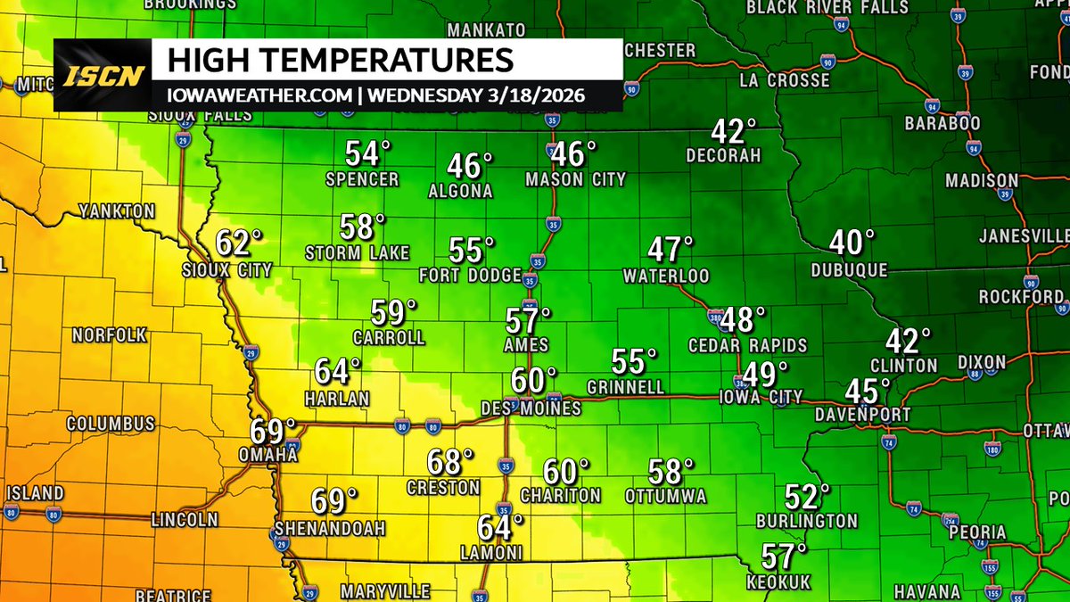
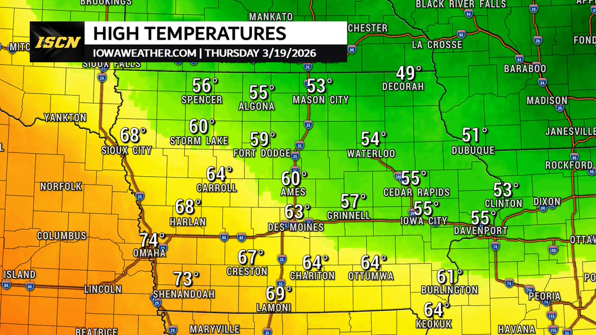
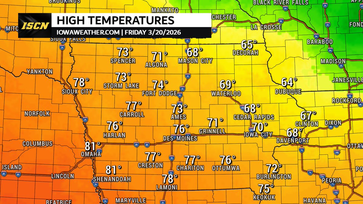
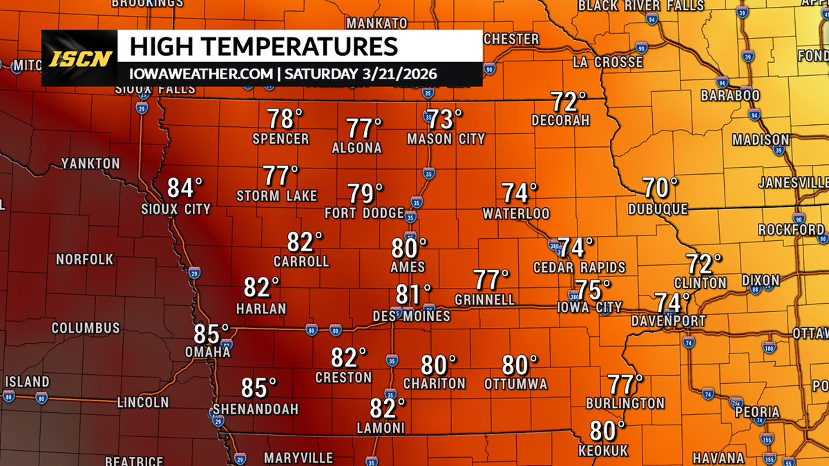
A big warm-up is coming to Iowa! Highs climb from the 40s–60s today, into the 50s–70s Thursday, then 60s–80s Friday, and 70s–80s Saturday across the state. A great stretch of mild, dry weather to wash off that winter grime.
IowaWeather.com tweet mediaIowaWeather.com tweet mediaIowaWeather.com tweet mediaIowaWeather.com tweet media
English
2
3
29
2.4K
IowaWeather.com รีทวีตแล้ว
CycloneJoe
CycloneJoe@CycloneJoe1·
Just took until halfway into March for me to finally see some sun dogs this winter 🙃 can almost follow them for a full halo and there’s a bit of a pillar too! @NWSDesMoines @IAStormChasing
CycloneJoe tweet media
English
0
3
16
1.5K
IowaWeather.com
IowaWeather.com@IAStormChasing·
I-80 Eastbound is blocked near Malcom, Iowa due to a crash. This video is as of 8:40PM Sunday. #iawx #iowa
English
1
10
34
6.3K
IowaWeather.com
IowaWeather.com@IAStormChasing·
I-35 from Ames to the Minnesota state line is closed. I-80 from Des Moines to I-880(previously known as I-680) in western Iowa is closed
IowaWeather.com tweet media
English
1
12
62
9.3K
IowaWeather.com
IowaWeather.com@IAStormChasing·
Here are the latest warnings as of 7PM Saturday. As a reminder, a blizzard warning will be in effect from Sunday morning through Monday morning. The blizzard warning will be in effect due to the crazy strong winds blowing around the snow and reducing visibilities. Not because the amount of snow.
IowaWeather.com tweet media
English
0
8
46
5.3K
IowaWeather.com
IowaWeather.com@IAStormChasing·
Winter Storm Watch Issued for Northern Iowa – Blizzard Conditions Possible This Weekend A potentially significant winter storm is now targeting parts of the Upper Midwest this weekend, and far northern Iowa is officially under a Winter Storm Watch. Timing: Saturday Night → Monday Morning Wind Gusts: Up to 50+ mph Snowfall: 6+ inches possible Impacts: Blizzard conditions, near-zero visibility, and dangerous travel Stay tuned for updates from Iowa Storm Chasing Network as this storm develops. #iawx #mnwx #wiwx #sdwx
IowaWeather.com tweet media
English
0
1
18
3.9K
IowaWeather.com
IowaWeather.com@IAStormChasing·
Possible video of the tornado over Donnellson, Iowa tonight @NWSQuadCities. Filmed by one of our followers SE of Donnellson, looking NW.
English
2
3
36
3.8K
IowaWeather.com
IowaWeather.com@IAStormChasing·
A tornado watch has been issued until 11:00 PM Tuesday evening. #ilwx #iawx
IowaWeather.com tweet media
English
0
1
11
3.3K
IowaWeather.com
IowaWeather.com@IAStormChasing·
@DonaldGavigan You can turn notifications on for our posts. Otherwise, you are at the mercy of the X algorithm showing you this post.
English
0
0
0
15
Donald Gavigan
Donald Gavigan@DonaldGavigan·
@IAStormChasing Wouldn't it be nice to get this the same day. I'm receiving this on Saturday 11:30. For Friday night forecast.
English
1
0
0
69
IowaWeather.com
IowaWeather.com@IAStormChasing·
A tornado watch has been issued for portions of central and southwest Iowa until 10PM this evening.
IowaWeather.com tweet media
English
2
2
13
2.1K
IowaWeather.com
IowaWeather.com@IAStormChasing·
There is also a 15% chance of severe hail across parts of the state. With a Level 1 hail intensity, some storms could produce hail larger than 2 inches in diameter. A 15% probability of damaging winds is also in place. With a Level 1 wind intensity, some storms could produce wind gusts up to 74 mph. Because storms will be moving quickly, it will be important to stay weather aware Friday afternoon and evening and have a way to receive warnings quickly. More updates will be provided as new forecast information becomes available.
IowaWeather.com tweet mediaIowaWeather.com tweet media
English
0
1
8
1.1K
IowaWeather.com
IowaWeather.com@IAStormChasing·
Storms are expected to begin developing after 4 PM Friday and will move across the state through the evening. The severe weather threat should move out of Iowa by around midnight. Storms are expected to move east-northeast at around 50 mph, meaning conditions could change quickly as storms pass through communities. There is currently a 5% tornado probability from northeast Iowa through central and southern Iowa. The outlook also includes a Level 1 tornado intensity, meaning that if tornadoes develop, some could reach up to EF2 strength.
IowaWeather.com tweet media
English
1
2
12
1.6K
IowaWeather.com
IowaWeather.com@IAStormChasing·
The latest outlook from the Storm Prediction Center continues to show a risk for severe weather across much of Iowa on Friday afternoon and evening. A Slight Risk (Level 2 of 5) remains in place for much of the state, while north-central and northwest Iowa are currently under a Marginal Risk (Level 1 of 5).
IowaWeather.com tweet media
English
1
3
21
2.6K
IowaWeather.com
IowaWeather.com@IAStormChasing·
We are still watching the potential for severe weather Friday afternoon into early evening. The Storm Prediction Center (SPC) has a slight risk of severe weather for most of the state of Iowa. The primary threats will be large hail and damaging wind gusts but tornadoes also appear possible. Stay tuned for more updates as things will continue to update the closer we get to Friday afternoon.
IowaWeather.com tweet media
English
0
1
22
2.2K
IowaWeather.com
IowaWeather.com@IAStormChasing·
Confidence continues to rise for a strong to severe storm setup Friday, with the Storm Prediction Center placing most of Iowa in a Slight Risk. A cold front will move into the state late Friday afternoon into the evening, bringing classic springtime ingredients supportive of strong storms. Current guidance keeps Iowa in the warm sector into Friday night, with storm chances increasing as the front arrives from the west. Higher severe probabilities are expected just south of the Iowa/Missouri border and extending south toward Oklahoma, where the setup currently looks more favorable. There is still some spread in the exact timing, but confidence in a strong thunderstorm risk Friday evening/night is growing. #iawx #iowa #severeweather #weatherupdate
IowaWeather.com tweet media
English
0
8
43
5.8K
IowaWeather.com
IowaWeather.com@IAStormChasing·
The Storm Prediction Center has expanded the Day 5 outlook (for Friday) farther north, now placing parts of southern Iowa in a slight risk for severe weather. Friday is shaping up to be a warm one across southern Iowa, with afternoon highs expected to climb into the upper 60s to near 70°. That warmth and increasing moisture could help fuel storms late in the week. It’s still several days out, and details will continue to change — but this is definitely something we’ll be keeping an eye on as we move through the week. #iawx #iowaweather #iowa #severeweather
IowaWeather.com tweet media
English
0
2
27
3.6K
MURICA
MURICA@Sable515·
@IAStormChasing how is this snowfall for Sunday looking for central Iowa ?
English
1
0
0
15