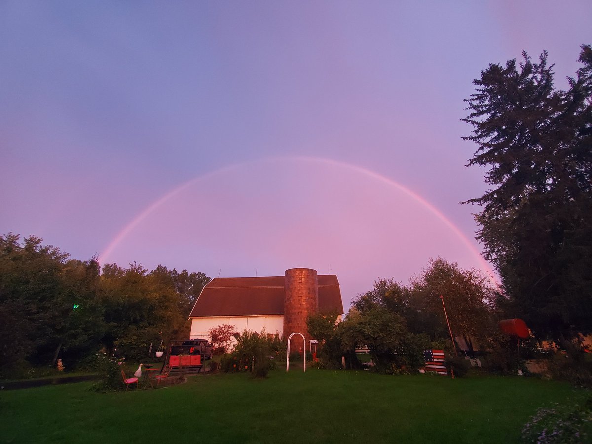
Julie Thompson

6.5K posts

Julie Thompson banner
Julie Thompson

Julie Thompson

@JuBug89

Storm & Craft lover. Instant Pot fanatic. Rookie photographer. Xbox One: RstBeefCurtn FB Pages: Chaos Carousel Creations & Knotty or Nice Crochet

Belleville, MI เข้าร่วม Mart 2013
872 กำลังติดตาม565 ผู้ติดตาม
Julie Thompson รีทวีตแล้ว
NWS Tornado
NWS Tornado@NWStornado·
Tornado Warning continues for Ralls County, MO until 8:45 AM CDT
NWS Tornado tweet media
English
137
397
3.7K
476.6K
Dave
Dave@MrDLTskol·
@TDStormRecovery @AdamLucioWX Surely now is the time for Reed and whole team to address this in the open? . It only ends one way otherwise, surely it must distract Reed and put pressue on his gut/ instincts to think of those people following as much as the actual chase.
English
1
0
3
505
Adam Lucio 🌪️
Adam Lucio 🌪️@AdamLucioWX·
This was one of the saddest things to see. People following the Dom so hard they literally pulled over next trees, unable to see anything. The janky bird fart tornado ongoing at the time was barely visible in the open, let alone through trees. I know the recovery vehicle has a purpose to follow, but everyone else? Pathetic. At one point prior to this the funnel passed nearly overhead as I sat on the side of the road watching, then the circus pulled up and things got clustered...had that thing actually planted into something real....yikes. Shortly after that and seeing how bad it was becoming, I had to change my strategy to simply put miles between myself and it all...the chase became more enjoyable minus the terrain/roads we were plagued with all day. There's a point where trying to be closest to get your little extreme storm chaser points isn't worth the loss of sanity. I'll gladly take a step back to breathe. I've got nothing to proove by trying to be mr zero meter all the time. I enjoy it, but only in certain circumstances.
English
47
27
423
210.1K
R A W S A L E R T S
R A W S A L E R T S@rawsalerts·
🚨#BREAKING: New Unconfirmed images are are being showed that allegedly show the suspected shooter who was either apprehended or reportedly neutralized by Secret Service agents at the Washington Hilton. This has not been officially confirmed just yet
R A W S A L E R T S tweet media
English
192
434
2.9K
376.6K
Julie Thompson รีทวีตแล้ว
NWS Detroit
NWS Detroit@NWSDetroit·
A Marginal Risk for severe thunderstorms exists roughly along and south of I-69 this afternoon and evening. Potential exists for isolated strong to severe storms capable of producing wind gusts to 60 mph and localized heavy downpours. #miwx
NWS Detroit tweet media
English
0
10
28
2.1K
Julie Thompson รีทวีตแล้ว
Michigan Storm Chasers
Michigan Storm Chasers@MiStormChasers·
Michigan State Police are asking anyone who has experienced damage (flood, tornado, wind, ETC) to use their reporting tool to report it. This helps in the process of securing funding for relief efforts and also helps resources / documenting of recent events. You can report your damage by following this link: survey123.arcgis.com/share/6e1d8996…
English
1
5
18
1.9K
Michigan Storm Chasers
Michigan Storm Chasers@MiStormChasers·
🥨 Trees turned into pretzels. In some instances, the evidence of a tornado is fairly clear-cut. EF-1 tornado damage from the Fenwick, MI area courtesy of the 18 mile long tornado that impacted Montcalm and Gratiot county back on April 14th, 2026, which had estimated winds up to 110 mph. Photo credit goes to Katie Holcomb and Hailey Fought. Nine tornadoes impacted Michigan on April 14th, bringing us up to 14 total in 2026.
Michigan Storm Chasers tweet mediaMichigan Storm Chasers tweet media
English
9
32
222
13.6K
Julie Thompson
Julie Thompson@JuBug89·
Getting so thick it's triggering my cameras 😅
English
0
0
0
547
Julie Thompson
Julie Thompson@JuBug89·
@NWSGrandRapids @MiStormChasers visibility 200 yards or less in many spots from Lansing down to Eaton Rapids from dense fog. 96 was okay but M99 was awful to the house here in Eaton Rapids. Picture doesn't do it justice.
Julie Thompson tweet media
English
1
0
0
34
Julie Thompson รีทวีตแล้ว
Michigan Storm Chasers
Michigan Storm Chasers@MiStormChasers·
🚨Sirens are sounding at the Croton Dam this afternoon as water levels continue to rise, prompting downstream evacuation orders to be issued. Again, if you live in the floodplain of the Muskegon River downstream of the Croton Dam, you NEED to be evacuating right NOW!
English
20
239
865
53K
Julie Thompson รีทวีตแล้ว
Michigan Storm Chasers
Michigan Storm Chasers@MiStormChasers·
We have issued an in-house internal discussion #2026-1 for southern lower Michigan valid through 3 am EDT. An internal discussion is to highlight zones where severe weather is anticipated or expected within the next few hours. A broken line of supercells is ongoing in Wisconsin, and parts of Iowa and Illinois, and with time tonight, this broken line will congeal, and move in from west to east, arriving in west Michigan between 9-10 pm EDT. Additional cells may fire up ahead of this line, also capable of an all-hazards (wind, hail, tornadoes) risk, but given a very subtle low-level capping inversion discovered on latest balloon launch data from MSC in Three Rivers, the risk for cells ahead of the main complex is leaning less-likely at the current time. We will still continue to monitor for any storms to break through the capping inversion ahead of the storms in Wisconsin. As a reminder, a capping inversion is like a lid on the atmosphere that prevents surface based storms. We still expect storms later tonight regardless of any capping inversion. Official Discussion Text "A cluster of supercells producing tornadoes, hail 3"+, and damaging winds over 70 mph in Wisconsin, Illinois, and Iowa will continue to move into a downstream environment in MI supportive of sustained updrafts. As time moves on, cells in Wisconsin will congeal into a line, making the primary hazard damaging winds 60-75 mph, with a secondary embedded tornado and hail risk. We expect a weather watch to be issued by the SPC in the next hour or two to account for a sustained all-hazards risk." -- Chief Meteorologist Joel Fritsma - 4/14/26 at 2335Z (7:35 pm EDT) --
Michigan Storm Chasers tweet media
English
7
26
133
10.4K
Julie Thompson รีทวีตแล้ว
Michigan Storm Chasers
Michigan Storm Chasers@MiStormChasers·
Here is our projected START times for the squall line later this evening, April 14th, 2026, which is expected to bring a chance for damaging winds 60-75 mph, and large hail 1-2"+ in diameter. In purple, the squall line should be moving into the shoreline communities between 8 and 9:30 pm EDT. As this line moves east-southeast, the US-131 corridor and surrounding areas will experience thunderstorms starting between 9-11 pm EDT. Eventually the US-127 and I-75 corridors in red will see the squall line as early as 10 pm EDT, but as late as midnight. For the thumb, midnight or later is expected for your start time. The random part of the graphic here is the large hatch region, which, for this map does not technically denote intensity, however, it does denote where prefrontal cells could take advantage of the early environment. These pre-frontals will need to be monitored for a very large hail, and increased tornado risk given current atmospheric profiles being primed. Not everyone will see pre-frontals, but the timing for pre-frontals will be primarily between 6-11 pm EDT. Please see our severe weather outlook released earlier this morning for exact probabilities for each region of the state. You absolutely should have multiple ways to receive warning as you head to bed tonight. Don't rely on just the sirens. Weather radios, phone alerts, notifications for when we go live here at MSC, and even call subscriptions are all crucial ways to receive warnings besides sirens, which are only intended for outdoor use. As always, whenever a warning is issued in Michigan, we will be live tracking right here at Michigan Storm Chasers. -- Trusted Partner of the Day -- Rainbow Restoration | 616-583-1234, call today for all your restoration needs in the Grand Rapids regional area!
Michigan Storm Chasers tweet media
English
7
66
350
34K
Julie Thompson รีทวีตแล้ว
Michigan Storm Chasers
Michigan Storm Chasers@MiStormChasers·
An elevated risk (MSC level 4 of 6) for severe thunderstorms has been maintained for this evening, April 14th, 2026. Discussion A primed summer-like environment capable of all hazards will move into place for this afternoon. Most of the day will be spent shedding morning showers, or sitting in partly cloudy skies. Depending on how warm we can get, discrete clusters of supercells may fire ahead of the main damaging wind complex. The damaging wind complex should start in Wisconsin, then move into Michigan around the 9-10 am timeframe. Any semi-discrete cells ahead of the main complex have the best chance at meeting the hatched hail risk and tornado risk criteria shown in the last two graphics. Remember, a hatched risk does not add extra percentages to the probability. It just acts as a bulletin denoting where stronger tornadoes, hail, or even wind would occur, if at all. The main complex later tonight would be responsible for any hatched-level winds (75 mph). There are a few factors that could hinder the severe threat, such as how long we can stay cloudy or rainy early on. This is where that capping inversion would be monitored, which is like a lid preventing storms to be rooted at the surface. Surface-based storms have the best chance at exclusively tornadoes. Additionally, we could overmix, and have too many storms early, sucking out all the atmospheric fuel for later. At the current time, solution one is more likely, if any. Timing will be at any point between 6 pm EDT tonight, through 4 am EDT Wednesday. Not everyone will get severe weather, but with probabilities higher than usual, this event theoretically should be more widespread across our medium and elevated risk zones. Additional storm chances are possible on Wednesday, and a forecast will be released later this morning for that risk. Good idea to share this outlook with a friend across southern Michigan this evening. We want everyone to be prepared, not scared, if severe weather strikes. Stay safe out there! -- Trusted Partner of the Day -- Rainbow Restoration | 616-583-1234, call today for all your restoration needs in the Grand Rapids regional area!
Michigan Storm Chasers tweet mediaMichigan Storm Chasers tweet mediaMichigan Storm Chasers tweet mediaMichigan Storm Chasers tweet media
English
5
16
125
11.4K
Julie Thompson รีทวีตแล้ว
Michigan Storm Chasers
Michigan Storm Chasers@MiStormChasers·
Coming soon… Set for release mid April.
English
3
5
57
2.4K