Rhodes Cartography

2.2K posts

Rhodes Cartography banner
Rhodes Cartography

Rhodes Cartography

@RhodesMaps

Maps, mapping, geoviz. No politics. Fellow @RGS_IBG. Board member @wmsmapsociety. Adjunct Professor @georgetownsfs. @thinkinginspace.bsky.social

เข้าร่วม Ocak 2020
467 กำลังติดตาม8K ผู้ติดตาม
ทวีตที่ปักหมุด
Rhodes Cartography
Rhodes Cartography@RhodesMaps·
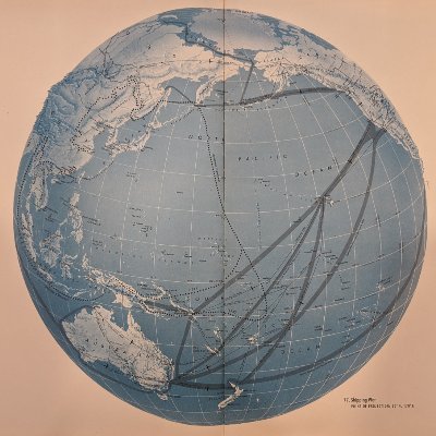
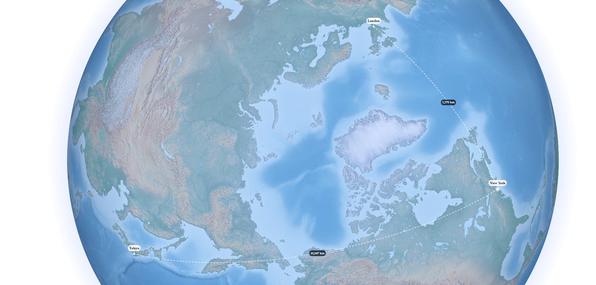
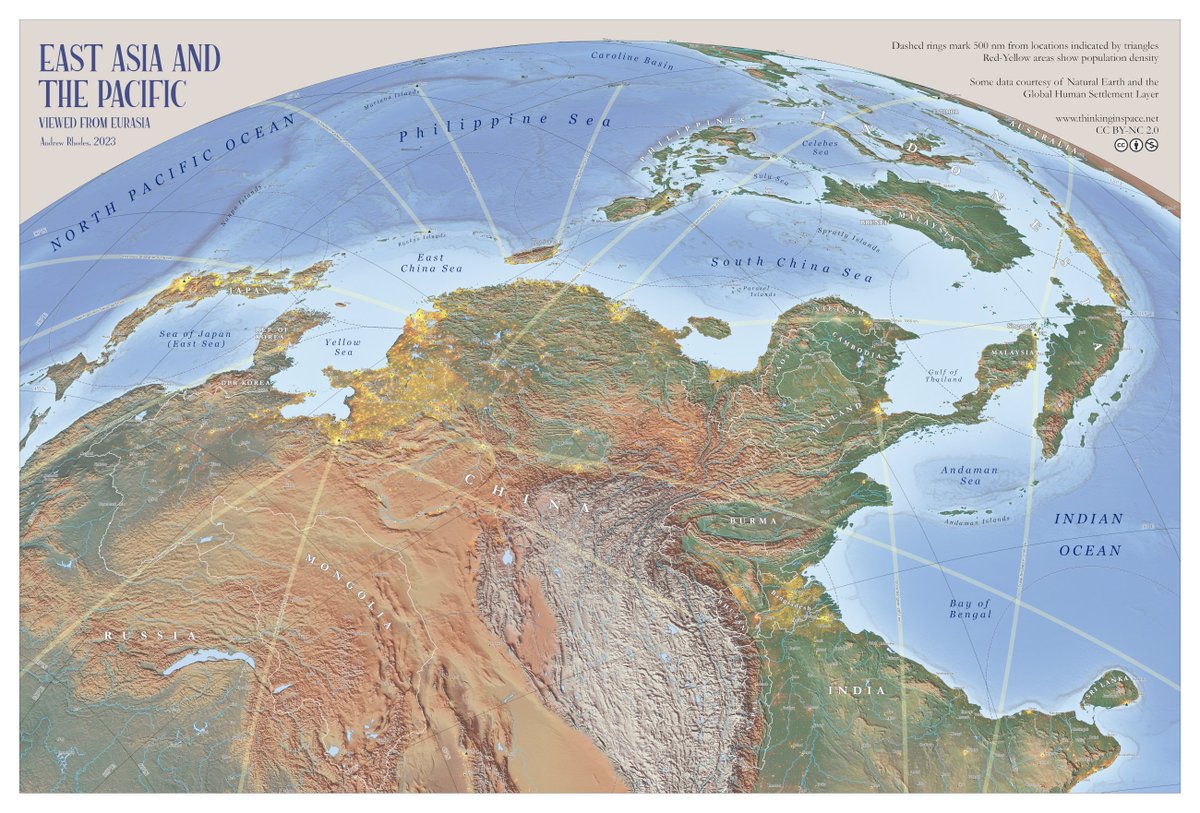
My new wall map "East Asia and the Pacific: Viewed from Eurasia" is now available for free (CC BY-NC 2.0) as a high-resolution download. Prints well at 20"x30" or larger. Thanks to everyone who provided helpful comments during many revisions. thinkinginspace.net/latest-maps/f/…
Rhodes Cartography tweet media
English
8
76
410
64.8K
Rhodes Cartography รีทวีตแล้ว
LegendesCartographie
LegendesCartographie@LegendesCarto·
[DOSSIER] Cette semaine, Histoire et géopolitique du pétrole ➡️ La carte du jour : Commerce et détroits stratégiques Le détroit d’Ormuz est un verrou clé du pétrole mondial : près de 20 % des flux y transitent, révélant la vulnérabilité du commerce énergétique.
LegendesCartographie tweet media
Français
1
21
39
2.9K
Rhodes Cartography รีทวีตแล้ว
Simon Kuestenmacher
Simon Kuestenmacher@simongerman600·
This 1962 map is a prime example of cartography as storytelling. A view of California and Nevada turns geography into a narrative. It layers landscapes with history, industry, wildlife, and culture in one sweeping visual. Maps like this don’t just show space, they explain it. Source features a high res zoomable version: davidrumsey.com/luna/servlet/d…
Simon Kuestenmacher tweet media
English
0
16
123
10K
Rhodes Cartography รีทวีตแล้ว
LOCMaps
LOCMaps@LOCMaps·
This fascinating mid-19th century Japanese map labels and charts the troops and samurai in charge of defenses along Tokyo Bay. Take a closer look here: loc.gov/item/84697512/…
LOCMaps tweet mediaLOCMaps tweet media
English
0
2
26
1.1K
Rhodes Cartography รีทวีตแล้ว
USGS
USGS@USGS·
The Moon, revealed through its geology. 🌗 Explore the Unified Geologic Map of the Moon! Created by @usgs_astrogeo, in collaboration with @nasa and other partners, this first-ever comprehensive map reveals the Moon’s entire surface geology, combining Apollo-era data with recent satellite missions. It not only shows the 4.5-billion-year history of our lunar neighbor, but also serves as a key tool for future human missions and an invaluable resource for scientists, educators, and space enthusiasts. Download the full map and legend 👉ow.ly/yY7l50YAPCY 📹: This animation shows a rotating globe of the Unified Geologic Map of the Moon with shaded topography from the Lunar Orbiter Laser Altimeter (LOLA). Credit: NASA/GSFC/USGS. #NASA #Moon #GeologicMap
English
12
338
900
128.9K
Rhodes Cartography รีทวีตแล้ว
verygoodmaps
verygoodmaps@verygoodmaps·
It's pretty amazing how much you can do in a single day when you have some good quality vector layers to work with. I'm using populate places layer from NaturalEarth. Obviously not done yet, now the pixel pushing starts. #europe #naturalearth #GIS
verygoodmaps tweet media
English
3
8
165
17.6K
Rhodes Cartography รีทวีตแล้ว
Jonathon P Sine
Jonathon P Sine@JonathonPSine·
One thing mapping war across Chinese history illustrates is the importance of geography. The Wei River valley in the foreground time and again (W. Zhou, Qin, Han, Sui, Tang) served as base and way station for consolidating rule over broad, flat, populous north China plain.
Jonathon P Sine tweet media
Jonathon P Sine@JonathonPSine

An interactive website of warfare across Chinese imperial history. 3,735 battles geolocated and split by dynastic period. Drawn from the PLA Press' comprehensive chronology of Chinese warfare (中国历代战争年表) All data on site: chinawarfare.pages.dev

English
2
13
107
8.1K
Rhodes Cartography รีทวีตแล้ว
Evan Applegate
Evan Applegate@youwillmakemaps·
Re-intro at 8k: cartography’s my vocation and you should give it a shot. Hasn’t the Territory been good to you? Rough guide to DIY computer-mediated static maps: youshouldmakemaps.com My Illustrator/Photoshop files: evanapplegate.com/map-design-fil… Cartography tips thread: x.com/youwillmakemap… Mapmakers to follow: @MtnMapper @FleischerHannes @RhodesMaps @verygoodmaps @DonatasBruzas Register for this Slack channel if you have computer-map questions: thespatialcommunity.org ✦✢✦✢✦✢✦✢✦✢ My map outputs ✢✦✢✦✢✦✢✦✢✦ Maps for bills I’ve made maps for National Geographic, an oil refiner, an Ojai trail system, an El Segundo core-drilling startup (@DurinMining is hiring), listen if your money’s green I can likely make you a great map: themapconsultancy.com Maps for thrills Hand-lettered maps of California and the Tongass National Forest, an illustrated guide to L.A.’s best sidewalk flora...maps I had to make because they didn't exist nicemaps.evanapplegate.com Maps of sublime effulgence You’ll know it’s for you when you’re standing in front of one. Sui generis, backlit, 3,600 DPI, amber-hued, grab a magnifying glass and leave some noseprints on a 6 ft. map with 150-micron linework: radiantmaps.co Maps for the couch Buy a custom 100%-cotton map blanket woven in North Carolina: etsy.com/shop/thequercu… Map-talk For your next commute/30%-attention chore check out 48 podcast interviews with great cartographers and learn how to make worlds in pixels, graphite, threads, paint, ceramic, wood and metal (or if you need to fall asleep, try the Jamshid Kooros and Anthony Despalins eps): veryexpensivemaps.com Map gift guide I collected the best available map material culture, perfect for the thing-brained man in your life: evanapplegate.com/map-gifts Map sensory overload I just piled a bunch of physica map experiments in a grid at, you might find something you like gallery.evanapplegate.com The best maps are still to come, and you’re going to make them (threat).
English
0
3
45
2.4K
Rhodes Cartography
Rhodes Cartography@RhodesMaps·
Working on an upgraded version of the Great Circles applet, to show distances to multiple points from a central location.
Rhodes Cartography tweet media
English
1
0
19
969
Rhodes Cartography รีทวีตแล้ว
Craig Taylor
Craig Taylor@CraigTaylorViz·
#threejs continues to impress me - protoyping some rapid-response frameworks for visualising ais data that doensn't rely on overnight renders 😅! I'm always fascinated by the pattern of activity in busy shipping locations - good candidates to test the tool! #ais #dataviz
English
27
127
1.9K
125.1K
Rhodes Cartography รีทวีตแล้ว
Sylvain Genevois
Sylvain Genevois@mirbole01·
« Cartes imaginaires. Inventer des mondes » (exposition de la BnF du 24 mars au 19 juillet 2026) La BnF met à disposition une banque de 98 cartes imaginaires, une sélection de vues des collections exposées à cette occasion cartonumerique.blogspot.com/2026/03/cartes…
Sylvain Genevois tweet media
Français
0
8
12
798
Rhodes Cartography
Rhodes Cartography@RhodesMaps·
Latest addition to the collection...
Rhodes Cartography tweet mediaRhodes Cartography tweet media
English
1
0
27
947