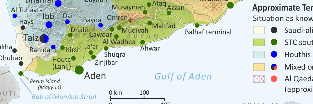
PolGeoNow

8.7K posts

PolGeoNow banner
PolGeoNow

PolGeoNow

@PolGeoNow

Political Geography Now reports on changes to the world political map and control of conflict zones. Visit our site for high-quality original maps and articles.

Beigetreten Ekim 2011
4.2K Folgt4.3K Follower
Keanu Nazari 📕
Keanu Nazari 📕@KeanuNazari·
I got thousands of rare Cultural Revolution-era photos from a historical archive here in China. I believe some of these have never been posted online, or only exist behind extremely expensive licenses. So here they are, for free. Open the thread for more.
Keanu Nazari 📕 tweet media
English
110
1.8K
12.9K
481.7K
PolGeoNow
PolGeoNow@PolGeoNow·
@EUAsylumAgency Should mention that data from @ACLEDINFO - reviewed line-by-line on our end - has increasingly been a big help in researching these maps, as they've grown their network of on-the-ground informants who can contribute information not covered by news media.
English
0
0
2
64
PolGeoNow
PolGeoNow@PolGeoNow·
@PythonMaps Confused at how to interpret two apparently contradictory color scales in the legend...
English
0
0
2
192
Python Maps
Python Maps@PythonMaps·
Forest Loss. This map shows forest loss since 2000 in Asia. Defined as a stand-replacement disturbance, or a change from a forest to non-forest state. For those who care - projection is EPSG:27703 is WGS 84 / Equi7 Asia
Python Maps tweet media
English
2
6
30
3.9K
PolGeoNow
PolGeoNow@PolGeoNow·
Hi, it's Evan. The money PolGeoNow brings in is probably a lot less than you think, and we're struggling a bit for funding right now. If you've ever wanted to support our work with a donation, large or small, it's now easy to do that at our Ko-fi page: ko-fi.com/polgeonow
English
1
1
2
164
PolGeoNow
PolGeoNow@PolGeoNow·
@hornaristocrat @HangingByA @HoehneVirgil @AAGA_CAWLAN101 Yes, that sounds generally correct, and matches what I illustrated on this map (notice that the diagonal lines represent "mixed/unclear"). Al Shabaab does seem to have stable positions at Ceel Garas and Ceel Lahelay south of Dhuusamareeb though (or at least did as of April).
English
0
0
1
47
HA📚
HA📚@hornaristocrat·
@PolGeoNow @HangingByA @HoehneVirgil @AAGA_CAWLAN101 Anything south of Dhusamareb is messy and hard to understand, large parts of Jubaland aren't even inhabited or properly controlled by anyone, but Shabab patrols there sometimes.
English
1
0
0
114
Markus Virgil Hoehne
Markus Virgil Hoehne@HoehneVirgil·
"Somalia - Approximate Territorial Control, 31 March 2026" EUAA COI May 2026: Somalia: Security Situation p. 20. Depicting the political complexities beyond political narratives.
Markus Virgil Hoehne tweet media
English
27
41
139
28.3K
PolGeoNow
PolGeoNow@PolGeoNow·
@husavia61225 That's a good point - there are ways to estimate population by satellite imagery now. But is that where your ChatGPT numbers came from? I've never seen a web page with such estimates for anywhere in Somalia/Somaliland.
English
1
0
0
146
Husavia
Husavia@husavia61225·
There’s modern ways of using satellite data and population projections to determine the sizes of rural areas and towns Anyone with a computer and internet connection can tell daroods are a very small minority within the borders of The Republic of Somaliland
PolGeoNow@PolGeoNow

@husavia61225 @HoehneVirgil @warsamohamed84 @mustafaadam I'm not sure there's enough recent information available for AI tools to even have the possibility of reliably telling you numbers like this. These are probably from old UN estimates.

English
1
0
0
240
Markus Virgil Hoehne
Markus Virgil Hoehne@HoehneVirgil·
Population numbers across Somali territories are notoriously unreliable. Since the times of Mohamed Siyad Barre (regarding the Ogadeen refugees in the 1980s) population numbers are shamelessly inflated. The last census in Somalia is from the mid-1980s and its results were never published. This also goes for Somaliland. Numbers are politics. Hargeysa had maybe 100-150.000 inhabitants in 1988; Burco maybe 50.000. Berbrra maybe 30.000 back then. Today SLanders would claim that during the bombardments and the atrocities of the regime in the late 1980s 200-250.000 people had been killed. How would that be even possible? In 2005, during the well-monitored parlamentary elections, across SL some 500.000 votes were cast. Now, if this included all above 18 years (including all parents) and you would add the underage children, you could arrive at a total population number of maybe 2,5 million back then. Yet official sources quickly jumped to 3,5, then 4, then 6 million (for SL alone). On which basis? Its just political rhetoric...
English
3
0
0
129
Husavia
Husavia@husavia61225·
@HoehneVirgil @PolGeoNow @warsamohamed84 @mustafaadam Erigaabo ~106,000- 200,000 lush/ green Caynaba ~57,500 arid/ semi dessert Gabiley 164,000- 220,000 lush/ green Badhan ~35,000-55,000 dusty tuulo Las qoray ~15,000 coastal tuulo Xudun 25,500 dusty tuulo The age of misinformation is over AI crushes darood propaganda
Husavia tweet media
Filipino
2
0
0
56
Al Jazeera English
Al Jazeera English@AJEnglish·
Heavy gunfire has broken out in central Mogadishu as Somalia’s former PM Hassan Ali Khaire says he has been attacked by gov't forces before planned anti-gov't protests aje.news/4ymfmu
Al Jazeera English tweet media
English
55
132
495
84.7K
PolGeoNow
PolGeoNow@PolGeoNow·
@liam_karr @criticalthreats @mikedeangelo25 Yes, I've seen your other maps, and I realize you understand the distinction. Maybe the main point is that a map (unless it also shows localized control) isn't a helpful way to illustrate the alignment of the different administrations. Some other kind of chart would be better.
English
0
0
1
9
Critical Threats
Critical Threats@criticalthreats·
NEW | Over a dozen countries, including the United States, called for the Federal Government of Somalia (FGS) and the leading Somali Future Council (SFC) opposition coalition to return to dialogue amid an intensifying constitutional and electoral dispute. The FGS’s attempts to consolidate political control across Somalia have put it on a collision course with the SFC and alienated even formerly pro-FGS Federal Member States. 🧵⬇️
Critical Threats tweet media
English
8
34
67
18.3K
PolGeoNow
PolGeoNow@PolGeoNow·
@EUAsylumAgency We're happy to have contributed the territorial control maps featured and cited in the Somalia Security Situation report! Readers interested in more details can find them on our site (though our 2026 report is still forthcoming): polgeonow.com/search/label/s…
English
0
0
2
82