Copy it up, Extraordinaire
250 posts

Copy it up, Extraordinaire
@CaseDisaster1
💪🏾🖕🏿
Massachusetts, USA Joined Nisan 2022
17 Following13 Followers

@StevesSwearBox It was on the scanner. 453 W waterworks Rd. Wabash Indiana
English

@CaseDisaster1 Have we got a rough location for this, so I can report it to NWS Northern Indiana?
English

@14TexasTornado @PabloEscoBone I'm also Black and not only know my father but was raised by him AND have a successful career.
GIF
English

@meteoroloquads I would have never seen that coming. Barely any velocities
English

@AdamLowisz When is this going to start popping off?
English

@JoshuaEvansWX Lppl how messy the environment is are you sure?
English

In all honesty my gut tells me today is about to go really big tornado wise. Observations look exactly like a pre outbreak look. If you’re under a tornado warning today take it seriously #wxtwitter #illinois #iowa


English

@ConspiraXavier @NWSSPC I'm not sure how anything can form with all that cloud and storm coverage in the area atm. Another poor forecast?
English

@NWSSPC calling it now. The tornado threat will bust. Way too messy of a setup
English

11:24am CDT #SPC Day1 Outlook Moderate Risk: across parts of northern Illinois, far eastern Iowa, and far southern Wisconsin spc.noaa.gov/products/outlo…

English

Love it when the closest radar for the tornado/flood risk zone has a beam sitting at roughly 15kft.


James Pettus@PettusWX
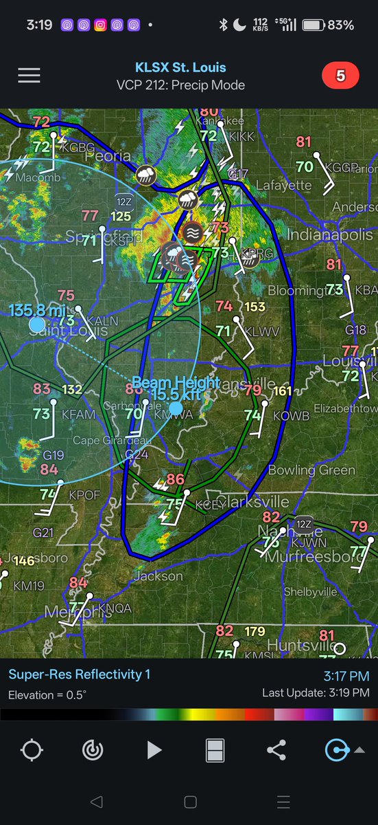
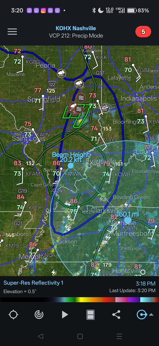
This is a very serious issue with the flood threat we have in place today through tonight, idk what the heck happened.
English

@LeonidaClips @Stargazerxviii No, he’s not. You’re projecting about being a racist retard because you’re a nigger who hates White people chimping out! Ooga Booga!!
English

@JaidenChasesWX @mark_rinne @ChaserDashboard @BrandonCopicWx @CoreyGerkenWX @ryanhallyall @FreddyMcKinneyR You seem angry? There's a thousand other mets saying the same thing on here. Go take a Xanax.
English

@CaseDisaster1 @mark_rinne @ChaserDashboard @BrandonCopicWx @CoreyGerkenWX @ryanhallyall @FreddyMcKinneyR Radar wasn’t close enough but I don’t think your head is big enough to consume logic so
English

Image from Pawnee City Tornado Emergency #tornado @BrandonCopicWx @CoreyGerkenWX @ryanhallyall @FreddyMcKinneyR

English

@mark_rinne @ChaserDashboard @BrandonCopicWx @CoreyGerkenWX @ryanhallyall @FreddyMcKinneyR Slow enough to where they didn't show up properly on radar or kick up anything into the air.
English

@CaseDisaster1 @ChaserDashboard @BrandonCopicWx @CoreyGerkenWX @ryanhallyall @FreddyMcKinneyR Oh really what were the wind speeds in it? Do you know?
English

@weathertrackus Where is the particularly dangerous situation?
English

I think NWS are just issuing Tornado Emergencies now to justify their poor model forecasting l...... There's not a tornado there unless it's invisible to radar. This is what happens when you cut the budget to our essential departments. #tornadoemergency
English

@StrmchsrHunterF The models need some adjusting then. Because everytime this happens the "Bust" crowd goes wild.
English

@CaseDisaster1 They made the forecast hours ago. This is real-time mesoanalysis model data/obs. Very different things.
English

Just looking at radar and mesoanalysis, we have very strong thermodynamics, but yet we have struggling tiny updrafts. I have two hypotheses here.
Some musing for the north and south areas.

Hunte☈ Fowkes@StrmchsrHunterF
Something that is catching my eye today is that the synoptics feel misplaced. With a curved jet, lift is found over the entire exit with suppression on the backside. Notice the zone of lift is given a glancing blow to our supercells across NE Kansas and SE Nebraska. The overall pattern is sliding along the edge of the risk area rather than arcing into the warm sector. Feels like a partial failure mode today playing out. Still, a robust environment remains regardless, and we are still far from being over today. The day is still young.
English


