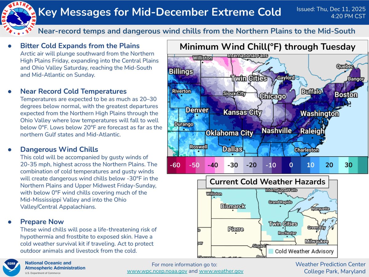
Tim Schmit 리트윗함
Tim Schmit
12.8K posts

Tim Schmit
@GOESguy
Satellite Research Meteorologist in Madison, WI. Likes GOES. Views posted here are my own. Photo: Fran Virum.
가입일 Nisan 2016
1.4K 팔로잉2.7K 팔로워
Tim Schmit 리트윗함
Tim Schmit 리트윗함

Derived Ash Height product from @eumetsat #meteosat10 suggested that parts of the volcanic ash cloud from the eruption of #HayliGubbi in Ethiopia may have reached heights in the 18-20 km range (black).
English
Tim Schmit 리트윗함

There were pilot reports of Extreme Turbulence yesterday over southwest Lower Michigan (causing some minor injuries) -- more details on the CIMSS Satellite Blog: cimss.ssec.wisc.edu/satellite-blog…
English
Tim Schmit 리트윗함

Wisconet is hiring!
Come join the premier mesonet of the Great Lakes and help us develop even more tools and applications to support farmers, growers, emergency managers, and the public!
Apply by December 7.
jobs.wisc.edu/jobs/wisconet-…
English
Tim Schmit 리트윗함

The @UWCIMSS Satellite Blog takes a new, in-depth look at the historical storm that sank the Edmund Fitzgerald 50 years ago: cimss.ssec.wisc.edu/satellite-blog…
English
Tim Schmit 리트윗함

The 50th Anniversary of the Wreck of the Edmund Fitzgerald: A New Perspective on an Old Storm: cimss.ssec.wisc.edu/satellite-blog…

English
Tim Schmit 리트윗함

1-min #GOESEast Infrared images w/ an overlay of GLM Flash Extent Density (large blue/cyan pixels) & GLM Flash Points (white dots) showed 3 brief signatures of lightning along the Indiana & Illinois coasts overnight - highlighting lake effect thundersnow. @NWSChicago #ILwx #INwx
English

50th anniversary of the first #GOES1 image. nesdis.noaa.gov/our-satellites… More: cimss.ssec.wisc.edu/satellite-blog… @NOAASatellites @UWCIMSS @UWSSEC
English
Tim Schmit 리트윗함

It's the 50th Anniversary of the launch of GOES-1! Check out this blog post celebrating 50 @NOAASatellites GOES loops, one for each state! cimss.ssec.wisc.edu/satellite-blog…
English
Tim Schmit 리트윗함

ICYMI, satellite signatures of the SpaceX Starship Test Flight 11 on Monday evening (13 October) can be seen on the CIMSS Satellite Blog: cimss.ssec.wisc.edu/satellite-blog…
English
Tim Schmit 리트윗함

In the early hours of July 4, 2025, a devastating flash flood occurred in the Texas Hill Country. Flash floods develop over a short period of time, making them life-threatening. NESDIS's STAR provides data and information to @NOAA’s @NWS, allowing them to detect potential flooding and issue timely and accurate warnings.
Learn more about STAR's work:
nesdis.noaa.gov/news/noaa-sate…
English
Tim Schmit 리트윗함

Watch this line of thunderstorms pass over Madison from 4 rooftop cameras as it goes over our building, along with @NOAASatellites GOES-19 true color imagery. Live feed of rooftop cameras and GOES-East composites here: cimss.ssec.wisc.edu/goes/rtc_goes_…
English
Tim Schmit 리트윗함

Major Hurricane #Erin, a Category 4 hurricane, is forecast to increase in size in the coming days. Refer to hurricanes.gov for the latest on #Erin.
English
Tim Schmit 리트윗함

Severe thunderstorm over southeast Arizona yesterday (6/30) shown in GOES-West 1-min VIS/IR Sandwich Imagery.
More satellite imagery from yesterday's southwest US thunderstorms: satelliteliaisonblog.wordpress.com/2025/07/01/sou…
English
Tim Schmit 리트윗함

Scott Lindstrom has published his last CIMSS Blog post. A very happy Retirement to him! cimss.ssec.wisc.edu/satellite-blog…
GIF
English
Tim Schmit 리트윗함

🚀 ¡Inscripciones abiertas!
Participa en el NOAA Satellites Hackathon 2025 🛰️
Una experiencia única para innovar, aprender y colaborar con expertos del mundo satelital.
📅 Octubre 2025 (virtual)
🔗 Regístrate aquí: noaasathack2025.sched.com
#NOAASatHack #Hackathon #NOAA

Español
Tim Schmit 리트윗함

Getting an early start today with the severe weather. A severe weather watch will likely be needed in the coming hours as storms start to build into our area. More in depth details below ⬇️
spc.noaa.gov/products/md/md…

English


