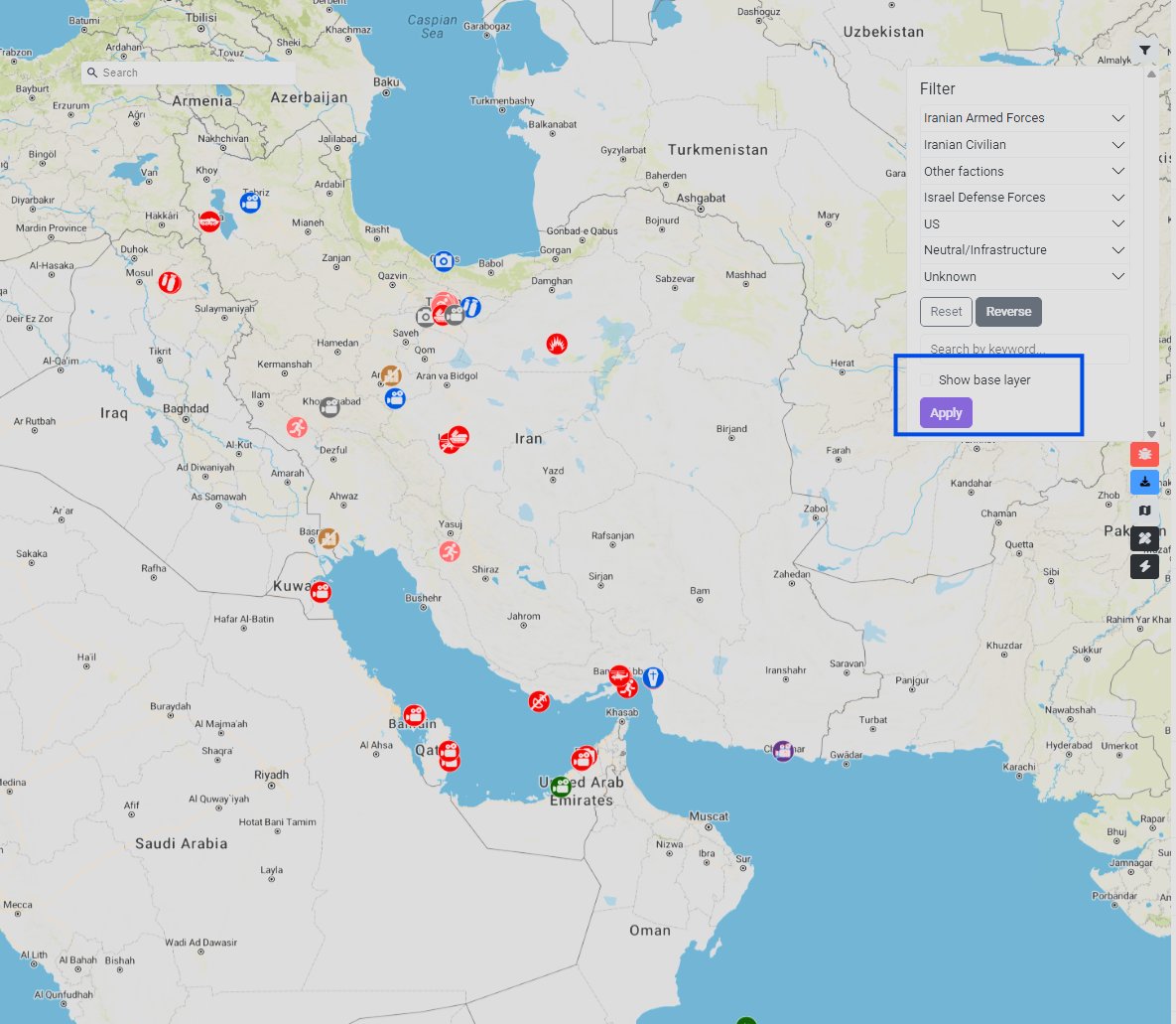
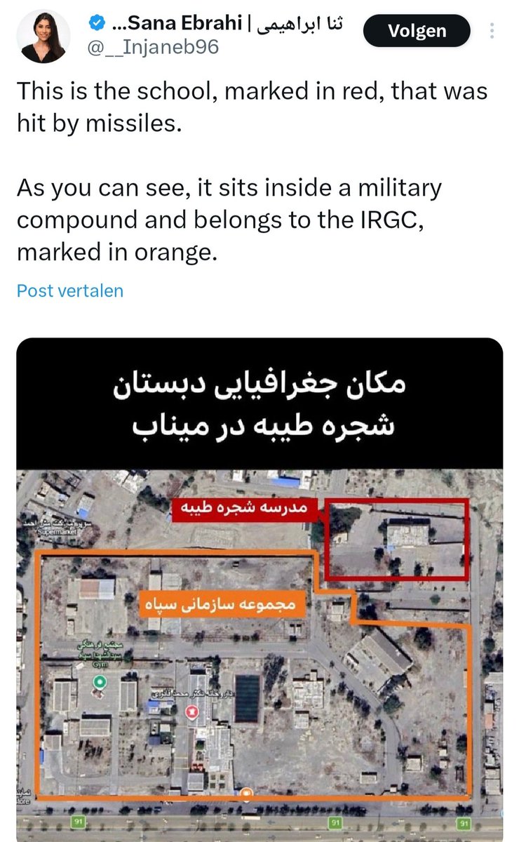
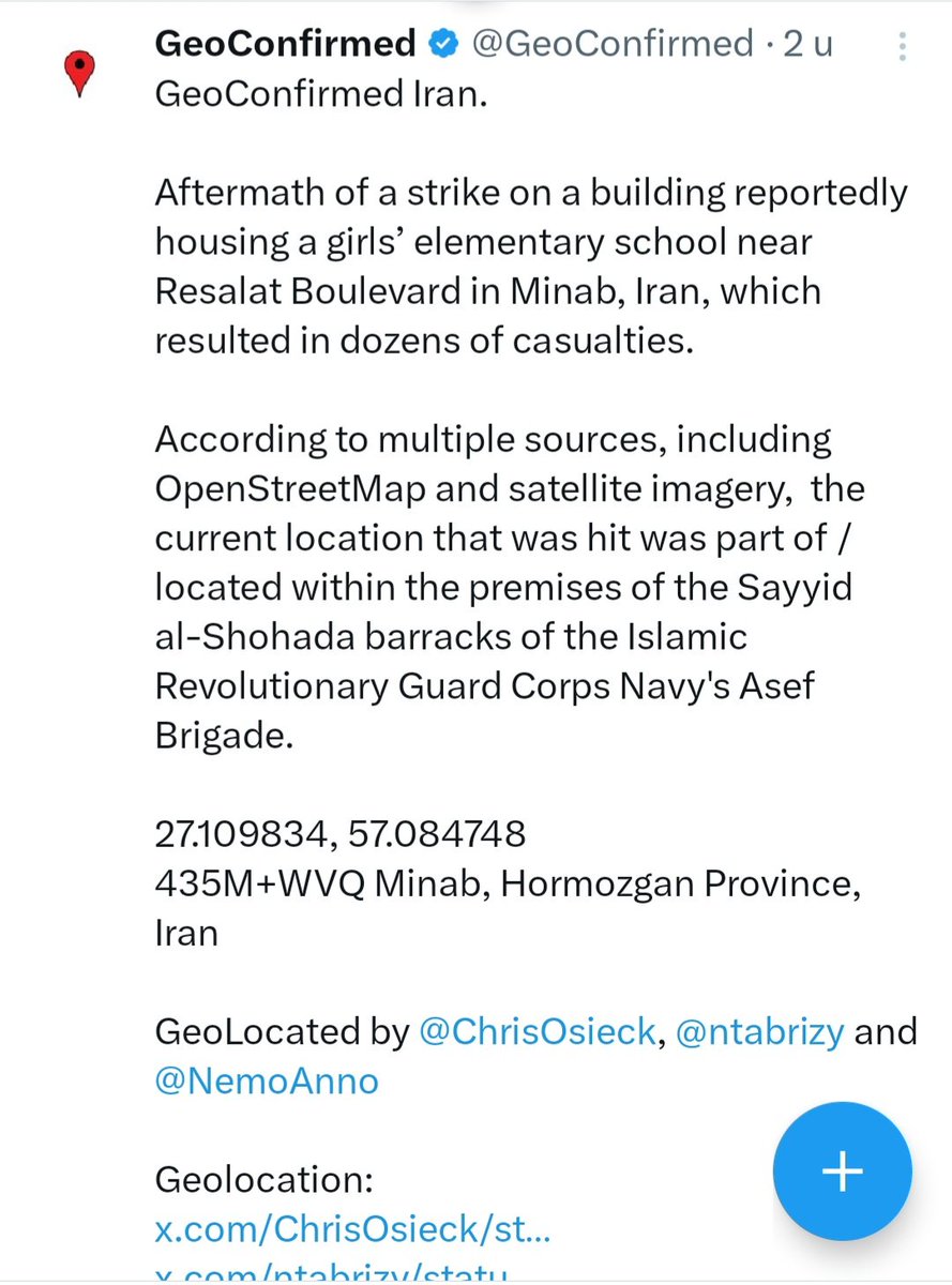
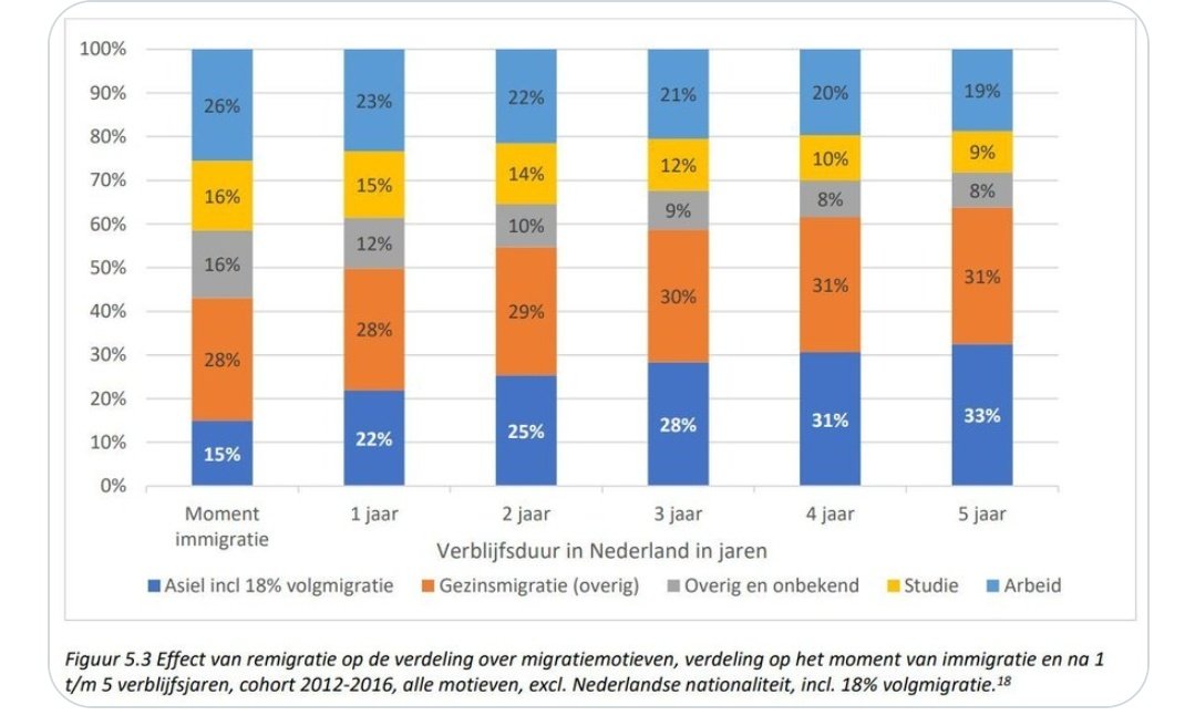
Archaeo - Histories@archeohistories
In 122 AD, Emperor Hadrian ordered construction of a massive stone barrier across the width of northern Britain, stretching 73 miles from the River Tyne to the Solway Firth. This formidable defensive fortification became known as Hadrian's Wall, the largest Roman archaeological feature in Britain. Built primarily by three Roman legions totaling 15,000 soldiers over six years, the wall originally stood approximately 12 feet high and featured a sophisticated system of forts, milecastles, and turrets positioned at regular intervals along its length.
The wall served multiple strategic purposes beyond simple defense. While its ditches, ramparts, and obstacles deterred casual raiders seeking livestock or slaves, the structure also functioned as a customs barrier and checkpoint system. Roman authorities could monitor and tax movement through designated gates, controlling both immigration and trade. The wall made a powerful psychological statement about Roman imperial might, possibly even whitewashed to reflect sunlight and visible for miles as a gleaming symbol of civilization's boundary against the "barbarian wilderness" beyond.
Nearly 10,000 auxiliary soldiers from across the empire garrisoned the wall's fortifications, profoundly impacting the region's demographics and economy. These troops and their families constituted 22-30% of the local population, creating demand that couldn't be met by local resources alone. The wall effectively divided what had been a unified cultural area, disrupting traditional settlement patterns and trade networks that archaeological evidence suggests had existed for centuries before Rome's arrival.
After Hadrian's death in 138, his successor Antonius Pius briefly abandoned the wall to build the Antonine Wall further north in Scotland. However, this proved unsustainable, and Hadrian's Wall was reoccupied as the primary frontier by 164 under Marcus Aurelius. The fortification remained manned until approximately 410 when Roman administration withdrew from Britain, though some sections continued occupation into the fifth century under local British control.
Much of the wall was dismantled in subsequent centuries, its stones repurposed for roads and buildings. Preservation efforts began in the 1830s when antiquarian John Clayton purchased land along the wall to prevent further destruction. Today, Hadrian's Wall is a UNESCO World Heritage Site and major tourist attraction, with a national trail allowing visitors to walk its ancient route and explore the exposed foundations and reconstructed sections that remain.
Hadrian's Wall fundamentally reshaped the social, economic, and cultural geography of northern Britain for centuries. The barrier severed a previously unified cultural zone, creating stark divisions between Romanized southern populations and northern tribal groups who were increasingly isolated from Mediterranean trade and influence. The massive military presence—nearly 10,000 soldiers and their dependents—permanently altered local demographics and economic patterns, creating demand for goods and services that transformed regional production and trade networks. Even after Roman withdrawal around 410, the wall's legacy persisted through the early medieval period, with some forts remaining occupied under British control and the physical structure itself serving as a readily available quarry that shaped local architecture for over a millennium. The wall's route influenced subsequent political boundaries and settlement patterns, while its modern preservation as a World Heritage Site has made it central to British cultural identity and heritage tourism, ensuring its economic and symbolic importance continues nearly two thousand years after construction.
#archaeohistories