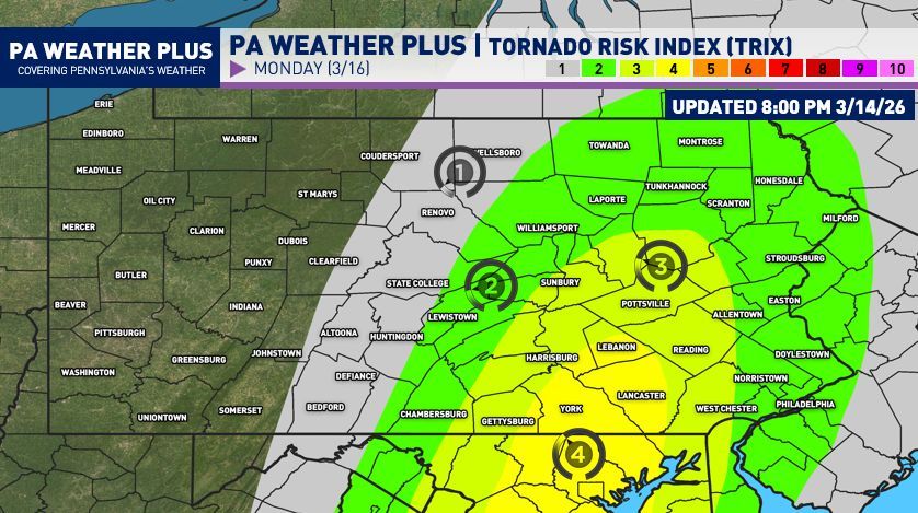
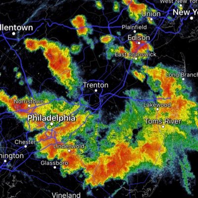
BrandonweatherWX

830 posts

BrandonweatherWX banner
BrandonweatherWX

BrandonweatherWX

@BGLovesWeather

Weather Enthusiast Since 2007, Storm Chaser, Gym Rat, Future Police Officer
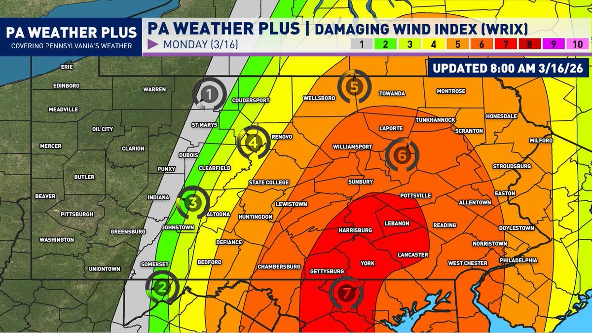
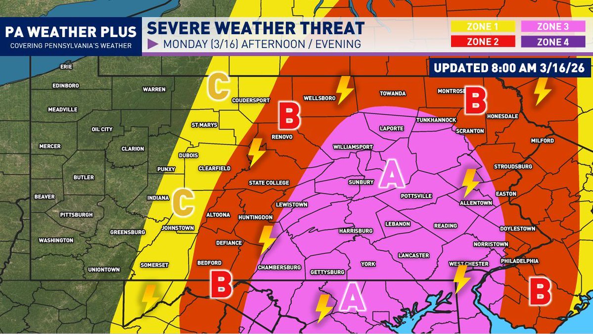
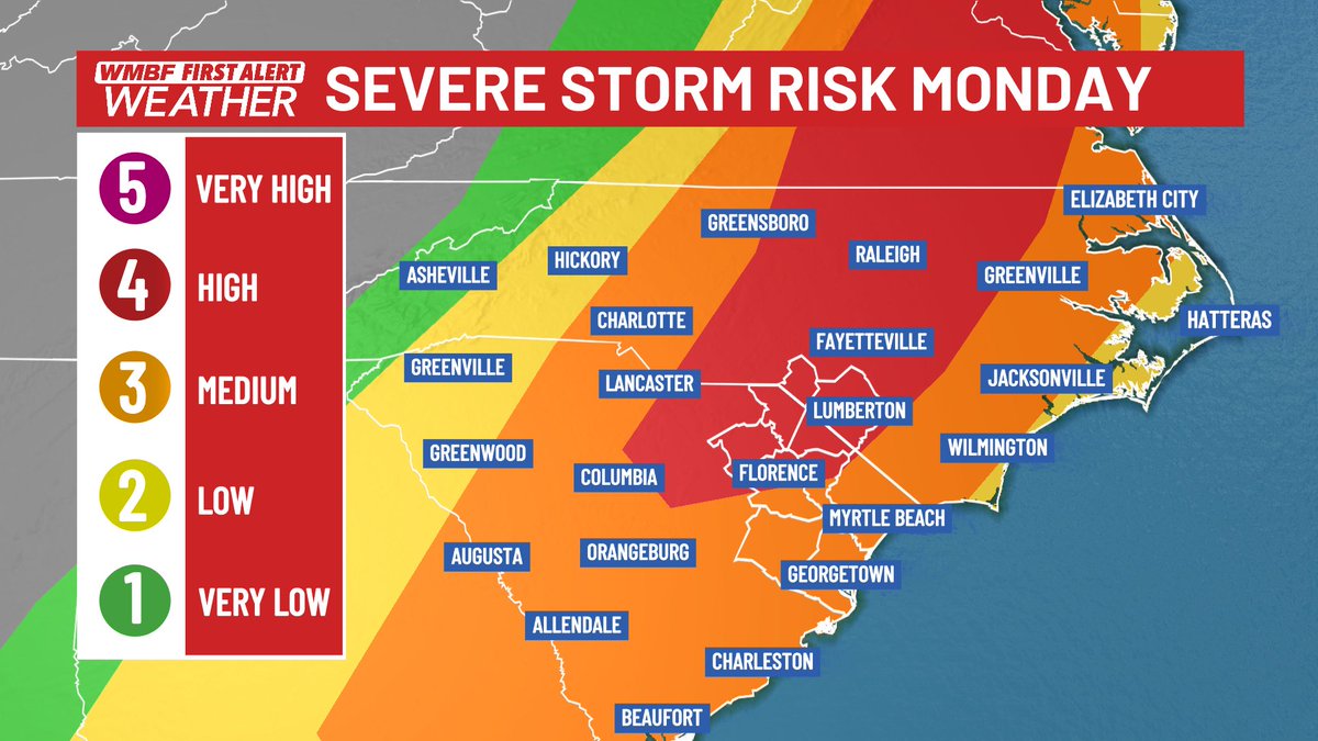
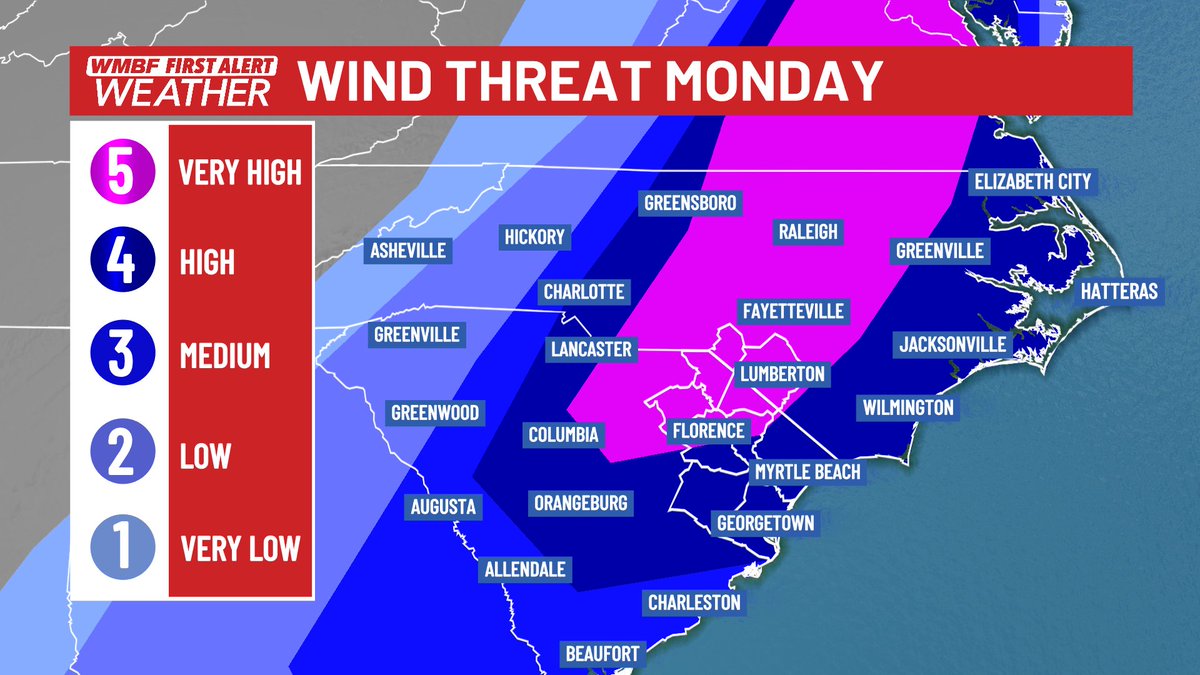
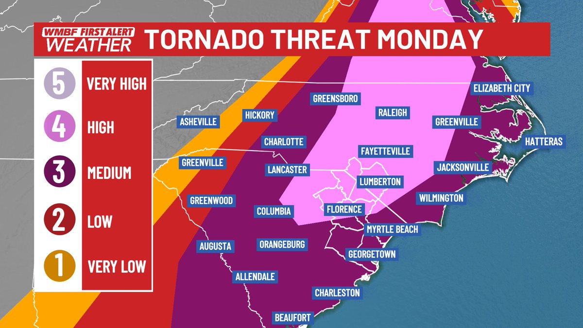
Katılım Ağustos 2020
93 Takip Edilen74 Takipçiler
Mike Stanislaw
Mike Stanislaw@mikestanislaw·
SPC Outlook remains. 2 areas I’m focusing on for greater concentration of winds & a few tornados. VA/NC should be the prominent zone, however C PA has some really strong forcing and LL helicity. I’m at a Med level of confidence, very complex field today. Things can/will change
Mike Stanislaw tweet media
English
4
3
40
12.4K
Veer
Veer@Veeringwindswx·
Chase target today is S PA for sure. Not only is there more curvature to the wind profiles with a markedly more backed LLJ, but destabilization aloft is also thicker/higher quality - being more shielded from stable, saturated thermodynamics to the south
GIF
Veer tweet mediaVeer tweet mediaVeer tweet media
English
3
4
55
4.7K
PA Weather Plus, LLC
PA Weather Plus, LLC@PAWeatherPlus·
** SEVERE WEATHER RISK SCALE FINAL UPDATE ** Introducing a new way to visualize the severe weather risk(s)… the TRIX (tornado) and WRIX (wind) scales! These are going to be scales ranging from 1 to 10, indicating the risk for either a tornado or damaging wind gusts (>58 MPH). While the normal scale of Zones 1 through 4 will continue to be used, these are new experimental graphics that I will work on to better visualize the scales! This also helps to visualize who has the best chance to see a certain severe weather threat and what that probability is, rather than just a zone outlook. These will also be correlated with the zone outlooks as a certain index number within a time range of a severe weather risk will be correlated to one of the Zone 1 - 4 risk zones! Think of this scale as a probability out of ten! (Example: A 6/10 on the WRIX scale indicates a 60% chance of experiencing damaging wind gusts of 58+ MPH within the selected day). What do you think of the TRIX and WRIX scales? Let me know in the comments if this is more confusing or if it better communicates the severe weather risks! #PAwx
PA Weather Plus, LLC tweet mediaPA Weather Plus, LLC tweet media
English
1
3
33
4K
BrandonweatherWX retweetledi
PA Weather Plus, LLC
PA Weather Plus, LLC@PAWeatherPlus·
** SEVERE WEATHER OUTBREAK EXPECTED MONDAY AFTERNOON / EVENING ** [FINAL SEVERE OUTLOOK UPDATE] A very dynamic system will be moving into the region this afternoon, which will bring numerous severe thunderstorms to much of central and portions of eastern Pennsylvania on Monday afternoon and evening. A strong cold front will cross the state, spawning a powerful squall line. Within the squall line, there may be circulations that could support weak spin-up tornadoes. Ahead of the squall line, any individual cells that develop can become supercells and can also produce weak tornadoes and damaging wind gusts. Today is one of the higher-end days that we've seen as of late, so it is important you stay tuned for updates and remain weather alert. TIMING: The ranges become wider in central and eastern Pennsylvania due to the risk for pre-squall supercells. The squall will come through in the afternoon to early evening, ushering in much colder air and ending the severe weather risk. ZONE 3 (A)- Watching for *NUMEROUS* strong to severe thunderstorms. These storms may produce damaging wind gusts of up to 70 - 75 MPH. A few spin-up weak tornadoes are not ruled out, and if one were to occur, it would likely be low intensity (EF0-EF1). An isolated supercell could produce up to EF2 strength. Non-severe thunderstorms may still produce gusty winds, lightning, and heavy rainfall. ZONE 2 (B)- Watching for *SCATTERED* strong to severe thunderstorms. These storms may produce damaging wind gusts of 55 to 65 MPH. A few spin-up weak tornadoes are not ruled out, and if one were to occur, it would likely be low intensity (EF0-EF1). Non-severe thunderstorms may still produce gusty winds, lightning, and heavy rainfall. ZONE 1 (C)- Watching for *ISOLATED* strong to severe thunderstorms. These storms may produce strong wind gusts of 50 to 60 MPH. Non-severe thunderstorms may still produce gusty winds, lightning, and heavy rainfall. Today will be a good day to remain weather aware and stay tuned for updates. Be prepared for rapidly changing weather conditions. Make sure you have multiple ways to receive severe weather alerts. Remember, when you hear thunder, head indoors! Stay safe and stay tuned! ⚠️🌪️
PA Weather Plus, LLC tweet mediaPA Weather Plus, LLC tweet media
English
0
8
44
4.8K
joseph martucci
joseph martucci@jtooch07·
Good morning, Lehigh Valley! We have a busy day of weather ahead of us! Morning showers will depart the area by 8am, leaving mostly cloudy skies with breaks of sun into the afternoon. Two rounds of thunderstorms can be expected today. Round 1 will begin to develop after lunchtime. Some of these storms may become supercells, which could spawn brief tornadoes. Round 2 comes after dinnertime as a squall line moves through. These storms will primarily produce damaging wind gusts, but the chance for a brief, isolated spin-up is nonzero. As the front passes through, and exits the region later tonight, a brief changeover to a wintry mix or snow is possible around midnight. Please be weather aware and keep your trusted weather source handy today as dangerous severe weather, with all hazards, is possible throughout the day. Have a great Monday! #PAwx
joseph martucci tweet media
English
1
0
5
414
Ben Williams
Ben Williams@ben_williams_wx·
Tomorrows risk across the Carolinas and Mid Atlantic probably deserves a Slight risk as of now... 😂 I don’t hate further north in PA, just lacking some directional shear
English
7
2
38
4.9K
Ryan Kane
Ryan Kane@ryankanerWX·
A rare moderate risk is in place for parts of the DMV for severe weather tomorrow: - Convective showers expected overnight after midnight - Quick moving showers Monday morning - Watch for pre-frontal cells 10am-3pm for DMV - QLCS squall line expected 3-9pm w/ widespread severe
Ryan Kane tweet mediaRyan Kane tweet mediaRyan Kane tweet mediaRyan Kane tweet media
English
5
8
46
7.4K
BrandonweatherWX
BrandonweatherWX@BGLovesWeather·
@epawawx That’s actually wild, the wind speed is different with every specific storm.
English
0
0
1
586
Bobby Martrich | EPAWA
I don't know who needs to hear this, but SPC risk levels don't necessarily imply higher wind. Just higher "probability" of severe gusts (58mph+) I'm seeing some correlate slight risk with 60-70mph, enhanced risk 70-80mph, moderate risk with 80-90mph. Not how it works. At all.
Coplay, PA 🇺🇸 English
15
4
120
13.4K
Bobby Martrich | EPAWA
𝗦𝗲𝘃𝗲𝗿𝗲 𝘄𝗲𝗮𝘁𝗵𝗲𝗿 𝗽𝗿𝗼𝗷𝗲𝗰𝘁𝗶𝗼𝗻𝘀 𝗳𝗼𝗿 𝗠𝗼𝗻𝗱𝗮𝘆 𝗠𝗮𝗿𝗰𝗵 𝟭𝟲𝘁𝗵: These are our proprietary outlooks, independent of the NWS Storm Prediction Center for tomorrow, Monday March 16th. Rather than regurgitate SPC information and passing it along which benefits no one, this is what a weather consulting firm does behind the scenes using our own proprietary methods. Typically this information is available only to forum and text alert members and private clients of EPAWA, but today is a freebie. The self-explanatory probability chart is the most valuable information in this case, with timing and chances to see the severe/on-severe parameters listed. If your location isn't on the chart, pick the closest one to you.
Bobby Martrich | EPAWA tweet mediaBobby Martrich | EPAWA tweet media
Catasauqua, PA 🇺🇸 English
25
22
164
19.1K
BrandonweatherWX
BrandonweatherWX@BGLovesWeather·
@epawawx @epawawx tomorrow is not looking good for Lehigh Valley, do you think they might extend moderate threat in that area :)
English
0
0
0
458
BGWX
BGWX@BradyBGWX·
If we see Tor Upgraded to 30 and go Cig 2 or Wind remain 60 and go Cig 2 we will see the first High Risk in the Mid-Atlantic to Carolinas in some time. I’d have to ask my man @NickKrasz_Wx when the last one was because I do not remember off the top of my head. But hard to compare Eye for an Eye with the new guidelines to the old ones given the differences so we’ll learn with time how each event compares to the next. Something to note for those comparing past history to current with SPC outlooks. But in this case the environment for severe weather will be a high impact day regardless of moderate or high risk.
BGWX@BradyBGWX

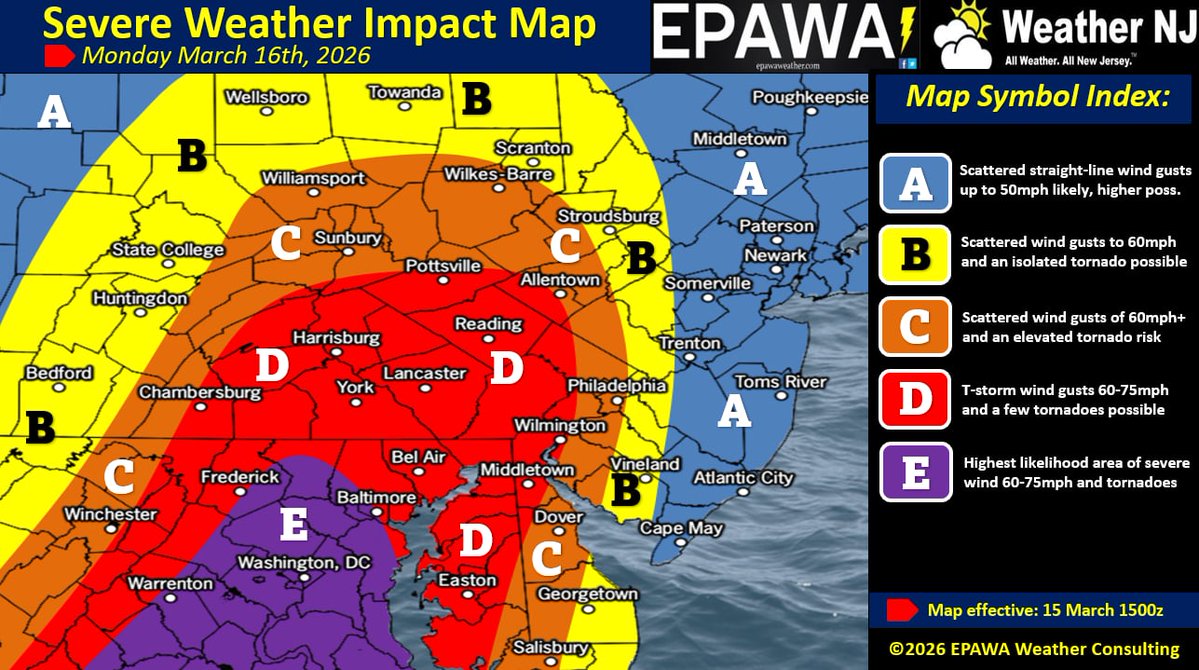
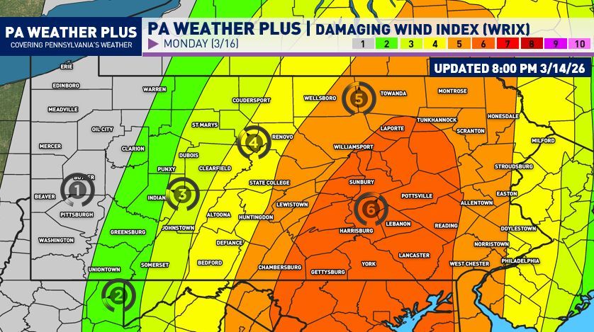
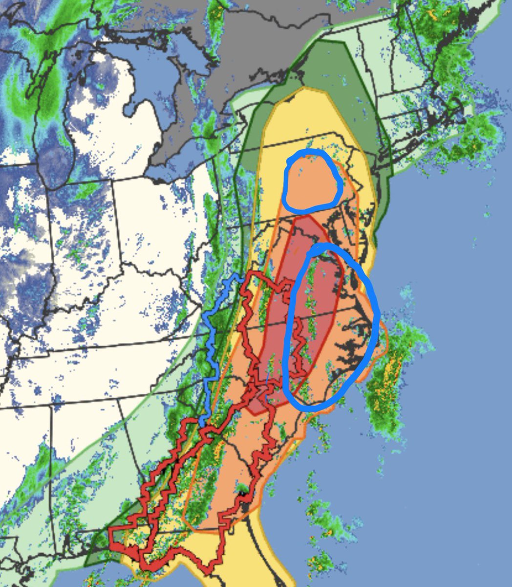
For those trying to understand the new SPC format this is a helpful graphic

English
3
2
19
3.3K
BrandonweatherWX
BrandonweatherWX@BGLovesWeather·
@MeteoMark Could you see east PA upgrading to Moderate? Is that a potential? I have never seen it before
English
1
0
1
126
Mark Margavage
Mark Margavage@MeteoMark·
It's Happening Again! As the old timers say, if you hear Thunder during the Winter, expect snow soon after. And yes, it is still technically winter until March 20th #wxtwitter #wxX #PAwx #NYwx #MDwx #NJwx
Mark Margavage tweet media
English
4
4
83
8.6K
Jamie Arnold WMBF
Jamie Arnold WMBF@jamiearnoldWMBF·
Digging into the risks on Monday shows the concern. While tornadoes will be possible virtually anywhere across the Carolinas, the risk will be maximized across the LEVEL 4 risk area where there is a high tornado risk. Some of these tornadoes may be on the ground for a long time. The damaging wind risk is about as high as we ever get in the Carolinas with VERY HIGH to HIGH risk covering a large area. Some gusts could potentially exceed 70 mph. #SCwx #NCwx @WMBFnews
Jamie Arnold WMBF tweet mediaJamie Arnold WMBF tweet mediaJamie Arnold WMBF tweet media
English
2
17
92
9.7K
BrandonweatherWX
BrandonweatherWX@BGLovesWeather·
@PAWeatherPlus Could you see east PA upgrading to Moderate? Is that a potential? I have never seen it before
English
0
0
0
42
PA Weather Plus, LLC
PA Weather Plus, LLC@PAWeatherPlus·
** SEVERE WEATHER RISK SCALE UPDATE ** Introducing a new way to visualize the severe weather risk(s)… the TRIX (tornado) and WRIX (wind) scales! These are going to be scales ranging from 1 to 10, indicating the risk for either a tornado or damaging wind gusts (>58 MPH). While the normal scale of Zones 1 through 4 will continue to be used, these are new experimental graphics that I will work on to better visualize the scales! This also helps to visualize who has the best chance to see a certain severe weather threat and what that probability is, rather than just a zone outlook. These will also be correlated with the zone outlooks as a certain index number within a time range of a severe weather risk will be correlated to one of the Zone 1 - 4 risk zones! Think of this scale as a probability out of ten! (Example: A 6/10 on the WRIX scale indicates a 60% chance of experiencing damaging wind gusts of 58+ MPH within the selected day). What do you think of the TRIX and WRIX scales? Let me know in the comments if this is more confusing or if it better communicates the severe weather risks! #PAwx
PA Weather Plus, LLC tweet mediaPA Weather Plus, LLC tweet media
English
4
5
42
4.6K
BrandonweatherWX
BrandonweatherWX@BGLovesWeather·
@BenNollWeather Could you see east PA upgrading to Moderate? Is that a potential? I have never seen it before
English
0
0
0
70
Ben Noll
Ben Noll@BenNollWeather·
For the third time in 13 years, D.C. is under a moderate risk (Level 4 out of 5) for severe storms Monday. "Tornadoes, potentially strong, and particularly damaging winds are most likely from South Carolina into Maryland during the afternoon," wrote the Storm Prediction Center.
Ben Noll tweet media
English
3
34
214
25.2K