binguswx

1.2K posts

binguswx banner
binguswx

binguswx

@Bingusprobably

17 | I LOVE weather🤤 (and bugs too) | 🦋(Moths) = 176 | 🕷️ = 54 |

Katılım Nisan 2024
90 Takip Edilen5 Takipçiler
binguswx retweetledi
Thee 🌪ornadorologist
Thee 🌪ornadorologist@tornadorology·
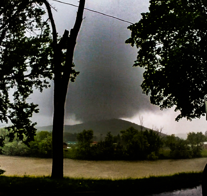
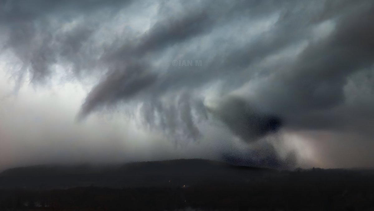
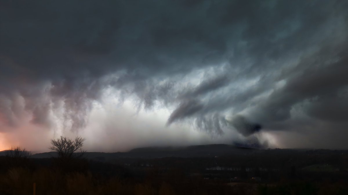
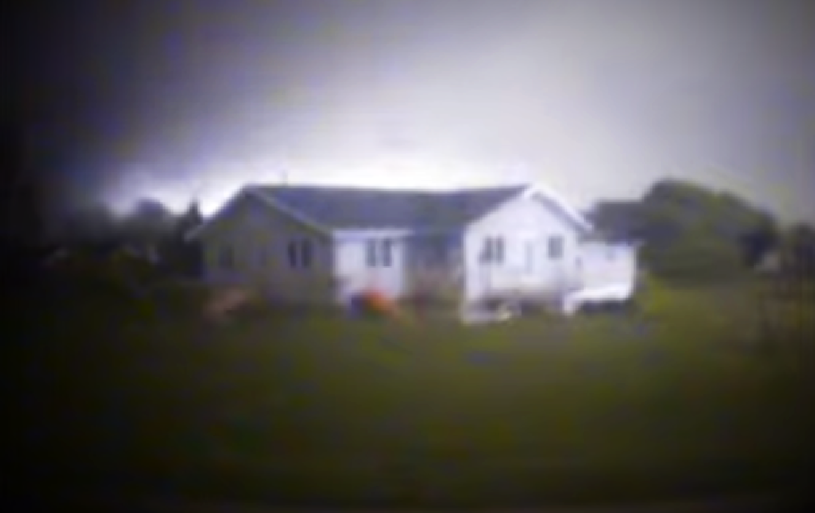
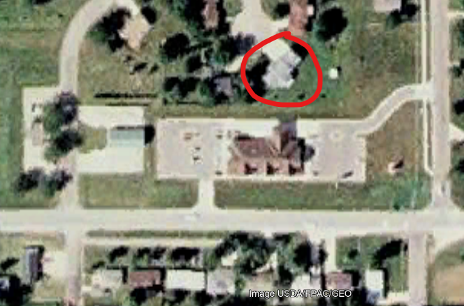
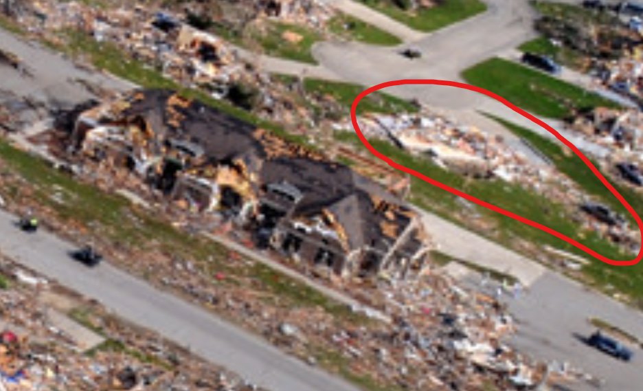
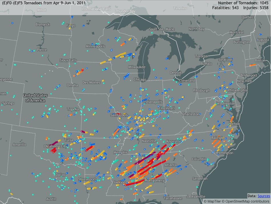
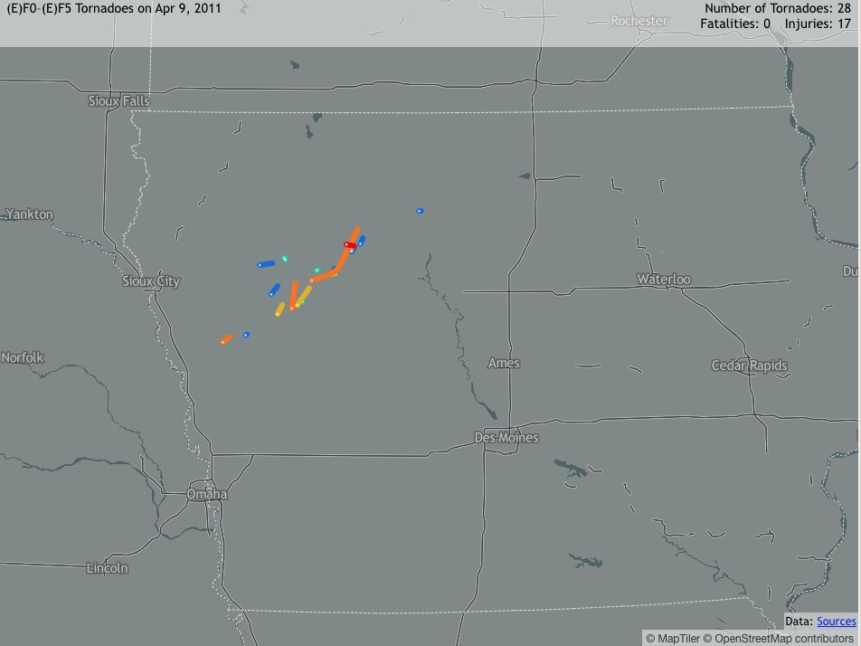
OTD 15 years began what I call it the “53 Days of Tornadic Hell.” 75% of significant to catastrophic tornadoes all happened in that span in 2011. It all started with the localized tornado outbreak in Iowa. #tornado #wxtwitter
Thee 🌪ornadorologist tweet mediaThee 🌪ornadorologist tweet media
English
2
9
78
3K
binguswx retweetledi
MyRadar Weather
MyRadar Weather@MyRadarWX·
A multi-day severe weather outbreak, with some tornadoes, begins Saturday. If you find this graphic overwhelming, so do we... there's just a TON to plot/discuss. These outlook zones come directly from NOAA/SPC. Saturday is an appetizer day as a dryline sharpens in West Texas. A jet stream dip/disturbance starts to approach. A couple supercells with egg-sized hail are possible. They'll congeal into a windy line overnight. Sunday the atmosphere resets, becoming warm and humid once again and allowing additional supercells to form. Hail up to apple size is possible, in addition to a tornado threat. Monday the risk area expands all the way up to the northern Mississippi Valley. A few tornadoes, as well as large hail, are likely. Some of the supercells may be intense, especially in Kansas. On Tuesday, a severe weather outbreak is possible as a potent jet stream dip (trough) swings overhead quickly. That will foster significant ascent (rising motion), resulting in scattered to numerous severe storms. Given the wind dynamics at play, tornadoes are likely to accompany the most severe storms. Wednesday, storms continue into the Mississippi Valley and Ozarks. Damaging gusts are likely, but we can't rule out some large hail or tornado risk.
MyRadar Weather tweet media
English
7
48
218
12.8K
binguswx retweetledi
Jim
Jim@yangyubin1998·
On the afternoon of April 9, thunderstorms moved south to northern Hunan and northern Jiangxi, with a suspected tornado hitting Pingjiang, Hunan.
English
0
11
25
1.9K
binguswx retweetledi
Patrick Hammer
Patrick Hammer@Pat_HammerWGRZ·
What's left of Lake Erie's ice.
Patrick Hammer tweet media
English
1
7
24
2.6K
binguswx retweetledi
Skies Of The UK
Skies Of The UK@SkiesOfTheUK·
A potentially historic severe weather outbreak is looming for southern and central China in less than 15 hours. Latest GFS data reveals a textbook "loaded gun" setup across Guizhou and Hunan, featuring extreme parameters including SBCAPE over 3,500 J/kg, 3km EHI values pushing 15, and Significant Tornado Parameters between 7.0 and 9.4. This highly volatile environment is primed for violent, long-track tornadoes and giant hail if discrete supercells form. Even if rapid storm consolidation occurs, the resulting squall line would pose a massive destructive wind and flash flooding threat driven by precipitable water values exceeding two inches. Meteorologists and locals must monitor this incredibly dangerous situation immediately. #ChinaWeather #SevereWeather #Tornado #WXTwitter
Skies Of The UK tweet mediaSkies Of The UK tweet mediaSkies Of The UK tweet media
English
6
30
185
44.7K
binguswx retweetledi
mads 🌪️
mads 🌪️@dubsinfive·
idk why but spelling it “tornados” pisses me off please don’t do that. add an e in there.
English
43
12
202
6.2K
binguswx retweetledi
BuffaloWeather
BuffaloWeather@weather_buffalo·
It’s April 7th…🥶
English
7
9
79
2.7K
binguswx retweetledi
MyRadar Weather
MyRadar Weather@MyRadarWX·
There are tornado outbreaks, there are high risks, and then there's what happened on April 7, 2006. The Storm Prediction Center draws an ultra-rare high risk – level 5 out of 5 – when there's a 30% chance of tornadoes within 25 miles of a point. (That seems confusing, but think about it this way... there's a 1 in 3 chance of a significant tornado hitting within a half hour drive of you.) That's pretty serious! But on April 7, 2006, SPC forecasters broke out a never before-seen contour – the 60% tornado risk. There hasn't been a 60% tornado risk issued since... not even on April 27, 2011. @MatthewCappucci dug through the archives. April 7 was the crescendo of a three-day outbreak from April 6-8; in all, 73 tornadoes would be confirmed across 13 states. The update came at 3:13 p.m. CT, shortly before all hell broke loose. Here's a snippet from the outlook issued by Chris Broyles: RAPID SUPERCELL INITIATION SHOULD TAKE PLACE JUST AHEAD OF A LOW TO MID-LEVEL JET PUNCHING INTO THE AREA. AS THE JET PUNCHES EWD ACROSS NRN MS AND NRN AL...SHEAR PROFILES WILL BECOME VERY FAVORABLE FOR LONG-LIVED STRONG TORNADIC SUPERCELLS. AN OUTBREAK OF STRONG TORNADOES SHOULD OCCUR ACROSS NRN AND CNTRL MS...NRN AL AND SCNTRL TN. AS THE STORMS TRACK ENEWD...SEVERAL LONG-LIVED VIOLENT TORNADOES NOW APPEAR INCREASINGLY LIKELY. In the end, two dozen tornadoes, mostly F0s and F1s, would hit northern Alabama. Interestingly, the strongest tornadoes – including a couple F3s – would track north of Nashville.
MyRadar Weather tweet media
English
4
43
397
50K
binguswx retweetledi
Ryan Scholl |-/
Ryan Scholl |-/@WxScholl·
The sky in the Badlands National Park is very busy tonight ✨
Ryan Scholl |-/ tweet media
English
2
7
54
963
binguswx
binguswx@Bingusprobably·
Thank you Hyannis
binguswx tweet media
English
0
0
0
7
binguswx retweetledi
iman
iman@imanHDwx·
@Bingusprobably King of the mountain slop 🔥
iman tweet mediaiman tweet media
English
0
1
4
101
binguswx retweetledi
iman
iman@imanHDwx·
Machias, NY - March 31st, 2026
iman tweet mediaiman tweet media
Deutsch
3
9
66
1.5K
binguswx retweetledi
NWS Buffalo
NWS Buffalo@NWSBUFFALO·
A line of gusty heavy showers is about to enter western New York. This line and an additional line of showers along a cold front will move eastward overnight and bring heavy rain and gusty winds to the region into early Sunday morning.
NWS Buffalo tweet media
English
0
7
37
5.6K
binguswx retweetledi
Nick Krasznavolgyi
Nick Krasznavolgyi@NickKrasz_Wx·
Ever wondered what the infamous Parkersburg, Iowa EF5 home was actually rated? The security footage from a bank camera was facing north toward a house with an open backyard. According to the official damage survey, that home was rated EF4. While no specific wind estimate was assigned, the level of damage suggests it was likely on the lower end of EF4 (DoD-9), with estimated winds around 170 mph.
Nick Krasznavolgyi tweet mediaNick Krasznavolgyi tweet mediaNick Krasznavolgyi tweet mediaNick Krasznavolgyi tweet media
English
2
30
236
13.9K
binguswx retweetledi
ChaseWithHam
ChaseWithHam@Ham_BklynWx·
Texan Clint Brock captured video of a possible tornado in the Lindale area this Saturday morning 🌪️ No reports yet from the national weather services at this time. #txwx #texas facebook.com/share/v/19HzBv…
English
2
17
52
3K
binguswx retweetledi
WeatherNation
WeatherNation@WeatherNation·
#BREAKING: A tornado was spotted churning through East Texas in the town of Lindale just earlier! Damage to homes & structures has been reported within the community. #TXwx
English
6
154
648
58.3K
binguswx
binguswx@Bingusprobably·
Best guess of the century 🥹
binguswx tweet media
English
0
0
0
9