BlueSky

2.9K posts

BlueSky banner
BlueSky

BlueSky

@BlueSkyWX

Pittsburgh Resident - ammature Tornado damage analyst - SVR weather lover

Pittsburgh, PA Katılım Mart 2022
438 Takip Edilen173 Takipçiler
BlueSky retweetledi
Ryan Vandersmith
Ryan Vandersmith@rvandersmith·
I've released a major update to mesoview.app: ~ Dark mode 
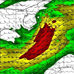
~ All SPC mesoanalysis products ~ WPC surface analysis ~ Pivotal Weather model data ~ Point soundings ~ Shareable URLs for real-time and archived data Enjoy, and let me know if you run into any bugs!
English
8
17
199
13.6K
BlueSky retweetledi
Convective Chronicles
Convective Chronicles@ConvChronicles·
SPC has now outlined severe weather risks for 5 of the next 6 days as we dive into a more active period for severe weather across parts of the US: *Tomorrow (Wed, April 8): Marginal Risk (level 1/5) for a few high-based storms w/ isolated large hail/damaging wind threat along frontal zone in Kansas *Thursday, April 9: Marginal Risk (level 1/5), potentially sneaky day with well-structured, all-hazards supercells possible along frontal zone in Kansas, transitioning to more multicells with isolated hail/damaging wind across west Texas *Saturday, April 11: Slight Risk-equivalent 15% area centered on west Texas for mixed-mode convection, including supercells, along a dryline as southwesterly flow overspreads the southern Plains...large hail/damaging winds the main threats *Sunday, April 12: Slight Risk-equivalent 15% area from southern Kansas to Texas for risk of supercells, potentially featuring all hazards, as impulse overspreads southern Plains *Monday, April 13: Slight Risk-equivalent 15% area from Midwest to southern Plains More risks to be outlined beyond Monday in subsequent outlooks. I'll have more info, including forecast videos, as we get closer to each of these days.
Convective Chronicles tweet mediaConvective Chronicles tweet media
English
3
18
127
9.1K
BlueSky retweetledi
Amelia Urquhart 🏳️‍⚧️
Take a look at that active period! It appears we may have conditions favorable for storms somewhere in the plains every day starting on Thursday and going out all the way to the end of the GEFS run.
Amelia Urquhart 🏳️‍⚧️@ameliaUrquhart_

I haven't heard any mention of it yet, but ens-omega is picking up on a possible setup Friday afternoon in Kansas. While shear is limited, good moisture, lift, and 7.5 C/km LRs will be in place north of Wichita. Mid-level RH will be around 60-70%, suggesting photogenic updrafts.

English
0
8
44
2.3K
BlueSky retweetledi
QuadWeather
QuadWeather@QuadWeather·
6 April Screenshot Roundup: 1. Low pressure bringing Florida some much needed rain 2. Late-season lake-effect snow in the UP of Michigan 3. Light precip in the equatorward entrance region of a jet streak in South Dakota 4. Rain associated with a shortwave moving through Arizona
QuadWeather tweet mediaQuadWeather tweet mediaQuadWeather tweet mediaQuadWeather tweet media
English
0
2
5
215
BlueSky retweetledi
Nick Krasznavolgyi
Nick Krasznavolgyi@NickKrasz_Wx·
Recently, I began a detailed analysis of the May 25, 2008 Parkersburg–New Hartford, Iowa EF5 tornado using Google Earth Pro imagery, official NWS data, and other sources. What initially appeared to be a single long-track tornado quickly turned into something much more complex… 🧵
Nick Krasznavolgyi tweet mediaNick Krasznavolgyi tweet media
English
5
43
247
22.9K
BlueSky retweetledi
JoshWx
JoshWx@jnphotographies·
Quick photo of a thunderstorm this evening out to the northwest, perfect setup with the lightning #PAwx
JoshWx tweet media
Lewisburg, PA 🇺🇸 English
0
1
7
141
BlueSky retweetledi
Kyle J Gillett
Kyle J Gillett@wxkylegillett·
Stripping away "the cloud" to visualize a supercell's anatomy, there are several take aways... 1. Downdrafts are not steady state features! 2. SVCs can contribute to *LLMC* enhancement 3. RFD surges may "collect" & converge vortex patches beneath the LLMC
Kyle J Gillett tweet media
English
17
122
765
40.8K
BlueSky
BlueSky@BlueSkyWX·
Possible tornado ongoing south east of Tyler Texas!
BlueSky tweet media
English
0
0
1
41
BlueSky
BlueSky@BlueSkyWX·
Possible weak tornado coming into van buren, AR!
BlueSky tweet media
English
0
1
4
66
BlueSky retweetledi
TornadoTRX
TornadoTRX@tornadotrx·
Baby tornado in Illinois today to start off April. Was just happy to be out there experiencing the storms :) #ilwx
TornadoTRX tweet media
English
18
35
546
33.4K
BlueSky retweetledi
Drew Brummel
Drew Brummel@WMstormchaserDB·
The rope tornado in West Liberty, IA from yesterday’s supercell
Drew Brummel tweet media
English
1
10
150
2.6K
BlueSky retweetledi
Mark Sudduth
Mark Sudduth@hurricanetrack·
Thanks to NASA and Artemis II, we can pretty much visualize a SKEW-T via this time lapse of the launch from my GoPro that was set up on a rock in Titusville. Enjoy! @foxweather
English
15
22
130
14.2K
BlueSky
BlueSky@BlueSkyWX·
5% CIG1 tornado risk in... ...Checks notes... The central IL MRGL risk tomorrow???
BlueSky tweet mediaBlueSky tweet media
English
0
0
0
61
BlueSky retweetledi
Andrew Pritchard
Andrew Pritchard@skydrama·
Mammatus and rainbows stole the show at sunset! Snapped near Laura, IL in northwest Peoria County.
Andrew Pritchard tweet mediaAndrew Pritchard tweet media
English
0
6
78
1.5K
BlueSky retweetledi
NWS State College
NWS State College@NWSStateCollege·
The classic PA weather divide! ☀️🏔️🌧️ SWPA is soaking up sun, but the rest of PA is stuck in a "wedge." SE winds are trapping cool Atlantic air against the mountains, keeping the East damp & chilly while the West stays warm. A quintessential COLD AIR DAMMING set up. ↖️📉 #PAwx
NWS State College tweet mediaNWS State College tweet mediaNWS State College tweet mediaNWS State College tweet media
English
2
5
25
1.7K
Connor Sipe
Connor Sipe@PAweatherPhoto·
Some more high-based spider lightning beneath a little thundershower in western PA tonight. Not the best view but I like how it peeks through the bare trees
Connor Sipe tweet mediaConnor Sipe tweet mediaConnor Sipe tweet media
English
1
0
4
68
BlueSky retweetledi
Nick Krasznavolgyi
Nick Krasznavolgyi@NickKrasz_Wx·
@QuadWeather Hey! Hope you’re doing well. I was wondering if there are any plans to add a “save image” feature in the future. It’s something a lot of my radar friends and I would really love to see, so I just wanted to pass that along in case it hasn’t been considered :) Screenshots don't work well on my end unfortunately, I prefer them without the beam height & gate value info, but I can't find a workaround for it. Just wanted to see if this was possible!
Nick Krasznavolgyi tweet media
English
1
2
45
1.8K
BlueSky
BlueSky@BlueSkyWX·
Another tornado on the ground NW of Dixon IL. Deep TDS with a tight velocity signature! #tornado
BlueSky tweet media
English
0
1
2
143
BlueSky
BlueSky@BlueSkyWX·
Possibly strong tornado near Delmar, IA. This tornado is moving very fast to the north east. #tornado
BlueSky tweet media
English
0
0
1
82