Chris Yates - WMBD Chief Meteorologist

12.7K posts

Chris Yates - WMBD Chief Meteorologist banner
Chris Yates - WMBD Chief Meteorologist

Chris Yates - WMBD Chief Meteorologist

@ChrisYatesWx

WMBD/WYZZ Chief Meteorologist Chris Yates is proud to be Your Local Weather Authority for Central Illinois.

Peoria, IL Katılım Haziran 2009
421 Takip Edilen2.4K Takipçiler
Chris Yates - WMBD Chief Meteorologist
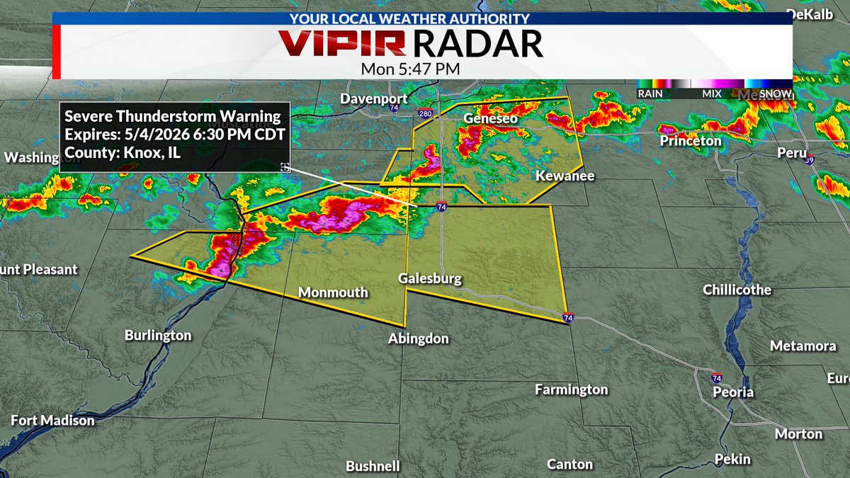
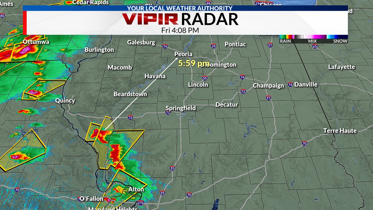
A Severe T-Storm Warning has been issued for Stark and Peoria Counties through 8:15 pm. Quarter size hail and 1.00" size hail is possible.
Chris Yates - WMBD Chief Meteorologist tweet media
English
0
0
2
185
Chris Yates - WMBD Chief Meteorologist
A Severe T-Storm Warning has been issued for northern Knox County, including Galesburg, until 6:30 pm. Quarter size hail and 60 mph wind gusts are possible.
Chris Yates - WMBD Chief Meteorologist tweet media
English
0
0
2
117
Chris Yates - WMBD Chief Meteorologist
Scattered showers continue to move across central Illinois but will gradually end from west to east through midnight. Skies will then clear overnight with areas of frost possible as temperatures fall into the mid to upper 30s. Posted 7:35 pm 4/30/26
English
0
0
1
253
Chris Yates - WMBD Chief Meteorologist retweetledi
Aaron Rigsby
Aaron Rigsby@AaronRigsbyOSC·
Significant damage in Mineral Wells, Texas from a tornado earlier this evening. #TXwx
English
76
619
2.5K
239.8K
Chris Yates - WMBD Chief Meteorologist
Scattered rain showers continue to develop over central Illinois. These showers will continue through about midnight (maybe a little longer near I-55) with amounts generally under 0.10" expected. Posted 9:35 pm 4/28/26
English
0
0
2
226
Chris Yates - WMBD Chief Meteorologist
Right now it appears frost will be more on the patchy side but could end up being more widespread along and east of I-55 and across far northern Illinois.
Chris Yates - WMBD Chief Meteorologist tweet mediaChris Yates - WMBD Chief Meteorologist tweet media
English
0
0
1
102
Chris Yates - WMBD Chief Meteorologist
We could see areas of frost late Friday night and Saturday morning as temperatures dip into the mid to upper 30s. The combination of a cool airmass, light winds, and clear skies will allow frost to develop where temperatures can drop below 38°.
Chris Yates - WMBD Chief Meteorologist tweet mediaChris Yates - WMBD Chief Meteorologist tweet media
English
1
0
1
235
Chris Yates - WMBD Chief Meteorologist retweetledi
NWS Lincoln IL
NWS Lincoln IL@NWSLincolnIL·
Record daily rainfall totals from yesterday: Springfield reported 3.62", breaking the old record of 1.93" set in 2002. Peoria reported 2.09", breaking the old record of 1.54" in 2002. #ILwx
English
0
11
12
1.4K
Chris Yates - WMBD Chief Meteorologist retweetledi
$herm
$herm@ShermBets·
@ChrisYatesWx very interesting clouds ☁️ tonight over Tremont! You have my permission to use these and share them if you would like!
$herm tweet media$herm tweet media
English
0
1
5
107
Chris Yates - WMBD Chief Meteorologist retweetledi
WeatherNation
WeatherNation@WeatherNation·
#BREAKING: A nighttime tornado touched down Clinton County, IL late on Monday. Multiple areas across the Midwest are expecting overnight severe weather, so make sure to have multiple ways to get alerts if a tornado warning is issued for your area.
English
5
73
370
22.3K
Chris Yates - WMBD Chief Meteorologist retweetledi
Doppler on Wheels (DOW)
Doppler on Wheels (DOW)@DOWFacility·
MiniCOW packs MegaPOWER! Observes birth and ingestion of satellite tornado and Fujiwara effect deflecting tornado. Tornado transitions 2x between clear eye and debris ball. Prelim data from most powerful mobile radar, 1 MegaWatt C-band storm-penetrating miniCOW in Braman, OK 🌪️
English
24
435
1.7K
126K
Chris Yates - WMBD Chief Meteorologist retweetledi
Okcweather
Okcweather@okcweatherpics·
Incredible hyper-lapse video of a large tornado moving across south Enid, Oklahoma! Captured with our Enid cam, you will see the tornado disappear into a curtain of hail only to remerge moments later! #okwx @KOCOMichael @NWSNorman @KOCOdamonlane @MikeMorganKFOR
English
44
751
4.9K
309K
Chris Yates - WMBD Chief Meteorologist
It will be another quiet night with temperatures faling into the lower 50s and upper 40s through midnight under mostly clear skies. Chances for showers and storms return late Tuesday afternoon and night, but severe weather is not expected. Posted 2:27 pm 4/20/26
Chris Yates - WMBD Chief Meteorologist tweet media
English
0
0
3
189
Chris Yates - WMBD Chief Meteorologist retweetledi
Reid Wiseman
Reid Wiseman@astro_reid·
Only one chance in this lifetime… Like watching sunset at the beach from the most foreign seat in the cosmos, I couldn’t resist a cell phone video of Earthset. You can hear the shutter on the Nikon as @Astro_Christina is hammering away on 3-shot brackets and capturing those exceptional Earthset photos through the 400mm lens. @AstroVicGlover was in window 3 watching with @Astro_Jeremy next to him. I could barely see the Moon through the docking hatch window but the iPhone was the perfect size to catch the view…this is uncropped, uncut with 8x zoom which is quite comparable to the view of the human eye. Enjoy.
English
4.1K
45.6K
265.5K
18.8M
Chris Yates - WMBD Chief Meteorologist
Severe storms along I-72 are expected to reach Fulton and Mason Counties around 5 pm then along I-74 around or shortly after 6 pm. Hail and damaging winds are the main threats with these storms. We'll begin our coverage as soon as these reach the view Mason County.
Chris Yates - WMBD Chief Meteorologist tweet media
English
0
1
5
359
Chris Yates - WMBD Chief Meteorologist
Severe storms moving out of the St. Louis area are moving to the NE at 45-50 mph. These storms pose a primary risk of damaging winds and large hail ans hould reach I-74 around 6 pm. Mason and Fulton Counties could be impacted as early as 5 pm. Posted 4:10pm 4/17/26
Chris Yates - WMBD Chief Meteorologist tweet media
English
0
0
2
274
Chris Yates - WMBD Chief Meteorologist
Tornado Watches have been issued for areas along and north of I-80 as well as areas to our west. This is mainly for storms developing along the warm front and prefrontal troughs. I suspect we'll see a Tornado Watch issued for the rest of the reigon later this afternoon.
Chris Yates - WMBD Chief Meteorologist tweet media
English
0
0
5
252
Chris Yates - WMBD Chief Meteorologist
A Severe T-Storm Watch has been issued for areas along and west of the Illinois River through midnight. A line of storms capable of damaging winds and perhaps a brief tornado will be possible. posted 7:56 pm 4/15/26
Chris Yates - WMBD Chief Meteorologist tweet media
English
0
1
2
348