Sabitlenmiş Tweet
Dimidium
85 posts


Dimidium
@DimidiumX
building different things tools, experiments, small systems Tool for Polymarket: https://t.co/GR8kpTPBt6 I would appreciate feedback
Katılım Şubat 2025
509 Takip Edilen32 Takipçiler

I have improved the GUI for the spectrum analyzer.
Vigyan@_phnx_1
PlutoSDR clones are not that BAD
English

@MicrosoftLearn Which course is the best for role Business Owner and
Solution Architect?
English

Do NOT doom scroll tonight.
Instead, learn a new skill. Comment for a course recommendation.
English

Small accounts tweeting to absolutely ZERO engagement

English

本日の野菜アンテナはタマネギでした🧅
この状態でSWR 1.4、リアクタンス10 Ω前後でした👍
430 FM 5局
TNX FB QSO‼️
タマネギ最長QRBは静岡県伊東市⇔千葉県大網白里市 約129 kmでした!

日本語

@zuhaitz_dev Cool find! I didn't know about B until now, and I’ve never looked into the history of C
English

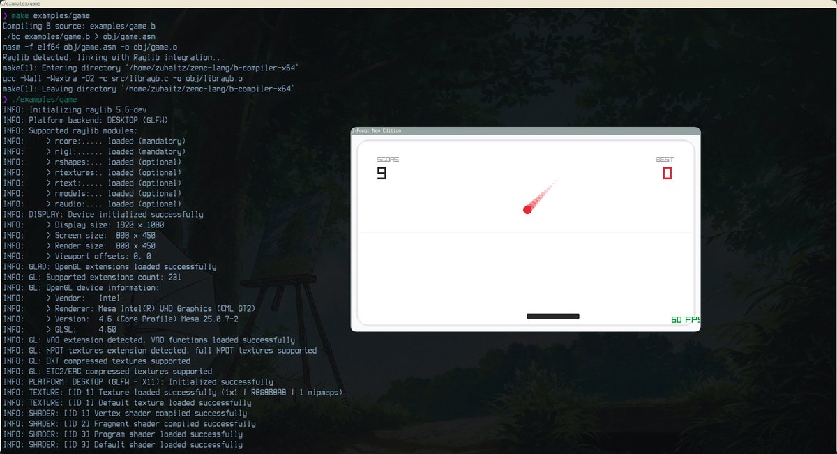
1st Week Project: a B compiler targeting x86-64.
C was heavily influenced by B, so I decided to write a compiler for it! I followed a Honeywell 6000 manual, but it targets x64 and respects the SYS V ABI.
It has C interoperability. So you can use stuff like raylib for example!

Zuhaitz@zuhaitz_dev
I need a job, so... I will work on a side project in C every week and share its source code on Sunday. It can be a compiler, a game, VM, shell, raycaster, ... I will obviously keep maintaining Zen C in the process.
English

@micheltamanda @TheAhmadOsman Many people want their own local model, but not everyone can afford it yet. It’ll become more accessible over time
English

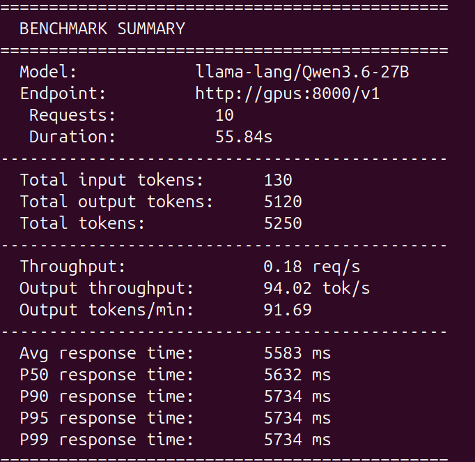
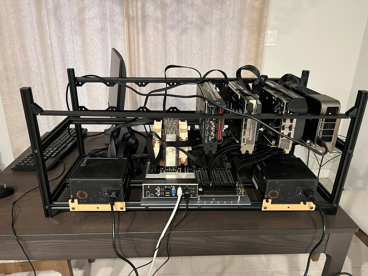
Buy GPU's said @TheAhmadOsman, so I did and had no clue what I was doing.
3 months later I have a fully local AI research operation, a solid understanding of AI, and confidence that AI will not take my job.
I ask you, for the sake of humanity: buy a GPU, learn to host your own intelligence.
Thanks to those who I learned from: @steipete , @0xSero , @Teknium , @LottoLabs , @NousResearch , @TheAhmadOsman , and many more I forgot to mention.
English
Who needs Google Maps when you have a terminal?
Runs in your terminal.
OpenStreetMap tiles, search, Unicode rendering.
github.com/Muid-lab/tui-m…
English
@AhmedShahnab Nice! How do you come up with this stuff? This isn't your first map project, and they're always so creative.
English

Bored of boring flat heatmaps?
Introducing Topographical Explorer that turns any country into a real-time tactile landscape
Search any country → watch real elevation data come alive as thousands of satisfying 3D blocks.
Built entirely client-side with:
- React Three Fiber + Three.js
- AWS Terrain Tiles + OpenStreetMap
- Real-time boundary
@threejs @reactthreefiber #DataVisualization #Geospatial #CreativeCoding #BuildInPublic
English
Cool to see these kinds of projects growing
Asimov@asimovinc
You can build, train, and customize a humanoid robot.
English


I'm making an incremental game where you build megastructures in space to harvest resources 🪐🌟
Build a Stanford Torus on Cindermoon to prestige to unlock permanent upgrades
English

@clippecac This looks amazing. Did you create this with code or software?
English
