FirstWARN Tri-Cities

15.3K posts

FirstWARN Tri-Cities banner
FirstWARN Tri-Cities

FirstWARN Tri-Cities

@FirstWarnTRI

Tracking weather in the Tri-Cities. We are the Tri Cities first warning when severe weather strikes. Partnered with @etnwxnetwork

Bristol, TN Katılım Ağustos 2020
169 Takip Edilen897 Takipçiler
FirstWARN Tri-Cities
FirstWARN Tri-Cities@FirstWarnTRI·
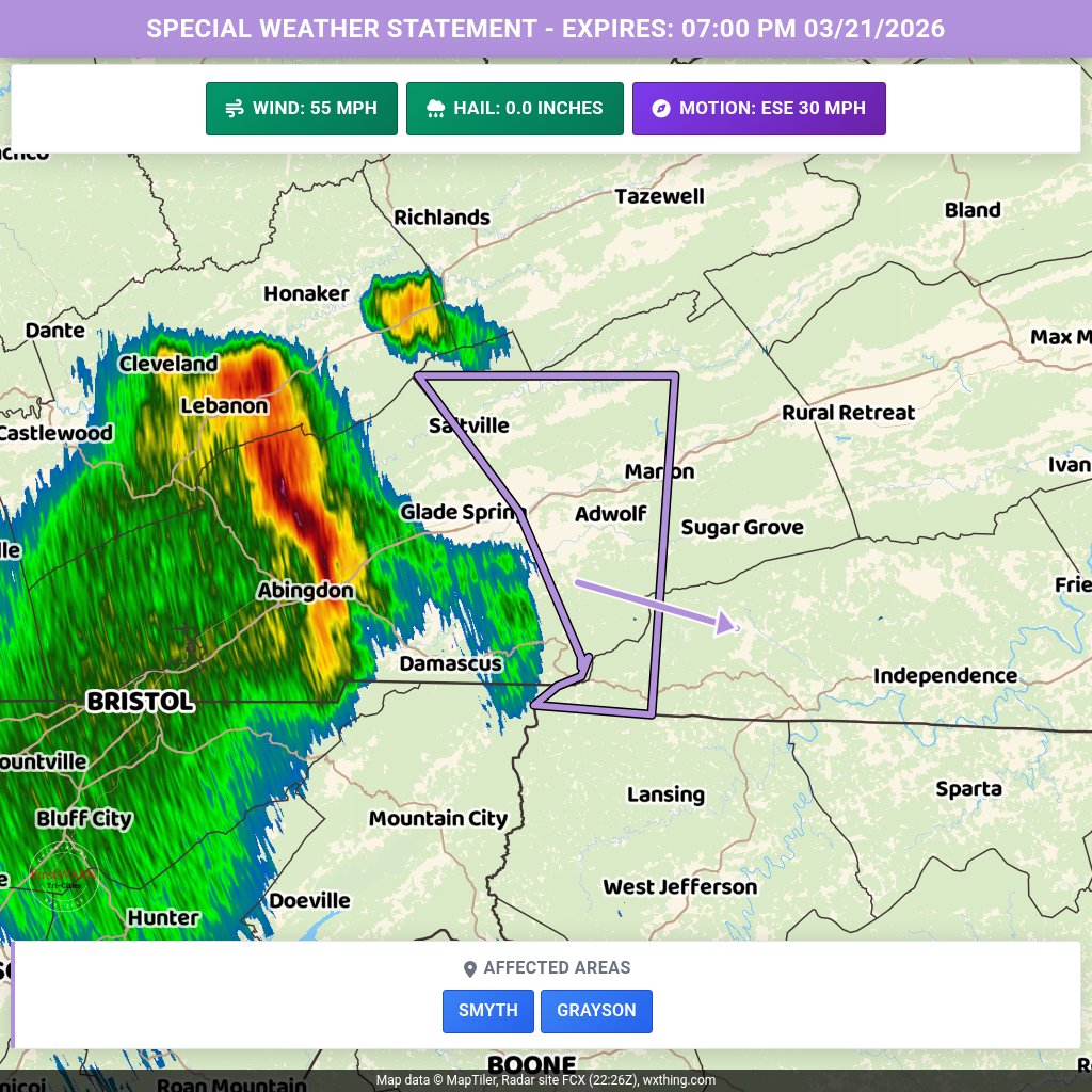
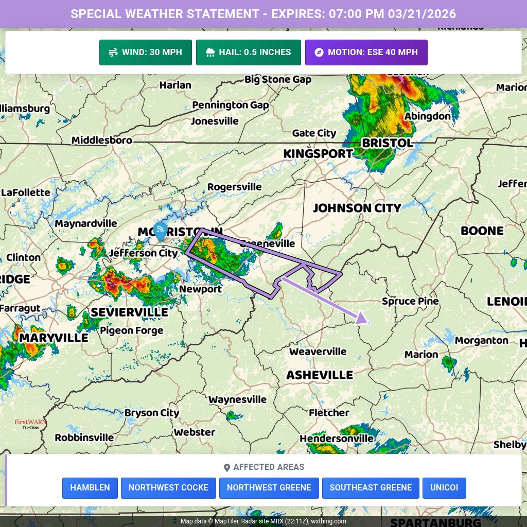
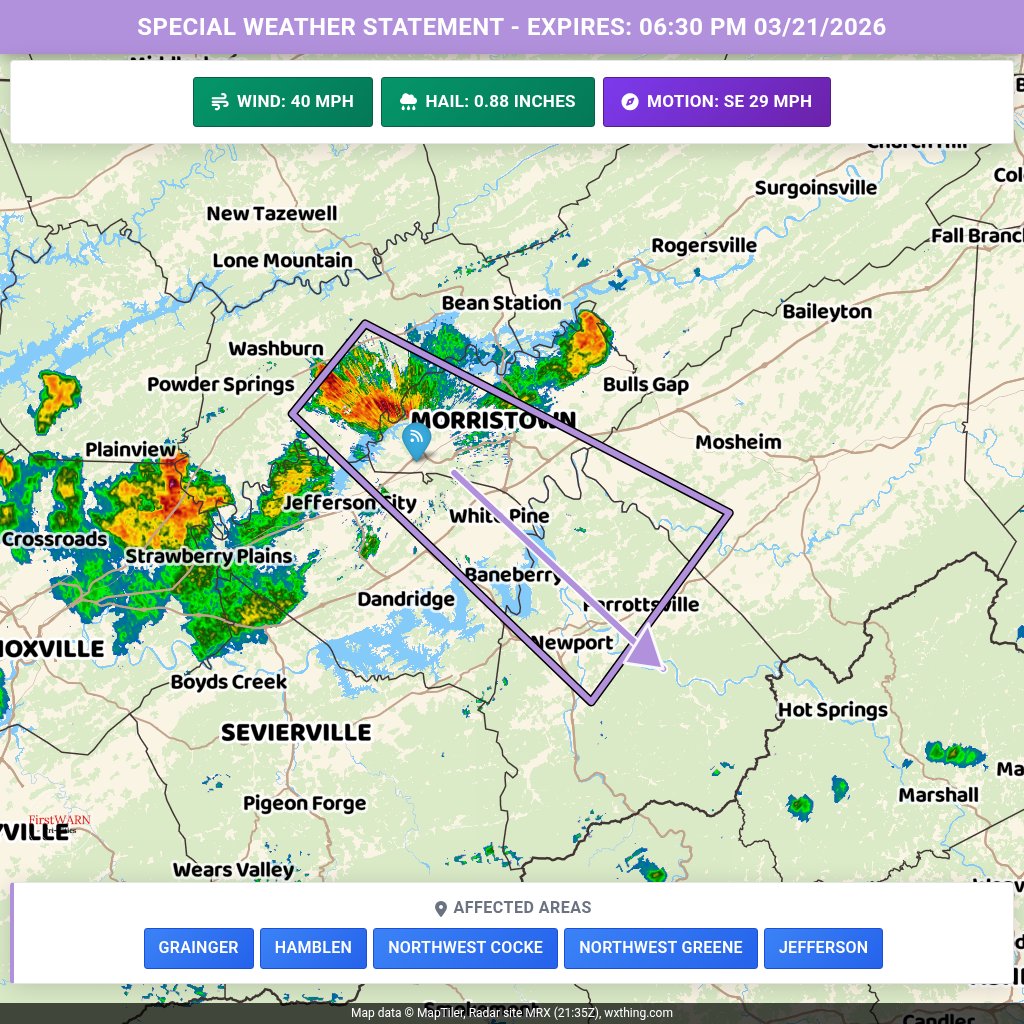
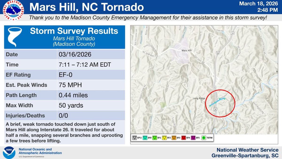
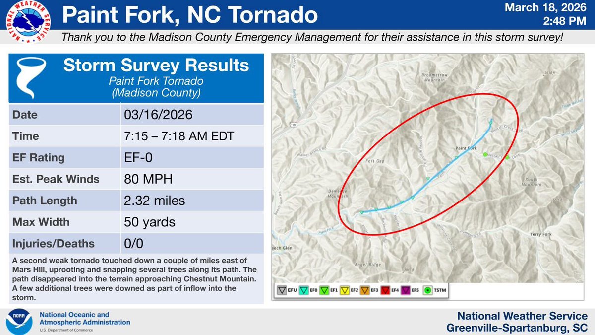
While the short-term severe threat is over an additional storm or two could develop over the southwest part of the area this evening. IF this occurs it could be strong with some hail. Stay tuned for the latest forecast updates.
FirstWARN Tri-Cities tweet media
English
0
0
0
55
FirstWARN Tri-Cities
FirstWARN Tri-Cities@FirstWarnTRI·
Special Weather Statement for Smyth and Grayson Counties until 7:00 PM. Wind gusts of 50-55 MPH are expected. Gusty winds could knock down tree limbs and blow around unsecured objects. Seek shelter indoors as the storm approaches.
FirstWARN Tri-Cities tweet media
English
0
0
0
42
FirstWARN Tri-Cities
FirstWARN Tri-Cities@FirstWarnTRI·
⚠️ SEVERE THUNDERSTORM WARNING ⚠️ A Severe Thunderstorm Warning has been issued for parts of Russell and Washington Counties in Southwest Virginia until 7:00 PM. This severe storm is impacting Lebanon now and pushing towards Meadowview. Quarter size hail is possible.
FirstWARN Tri-Cities tweet media
English
0
0
0
50
FirstWARN Tri-Cities
FirstWARN Tri-Cities@FirstWarnTRI·
Severe T-Storm Warning for Russell, VA & Washington, VA until 7:15 PM. Quarter-sized hail and winds up to 50 MPH are possible. Damage to vehicles expected. Move to an interior room on the lowest floor of a building for safety.
FirstWARN Tri-Cities tweet media
English
0
0
0
37
FirstWARN Tri-Cities
FirstWARN Tri-Cities@FirstWarnTRI·
Special Weather Statement for Hamblen, Northwest Cocke, Northwest Greene, Southeast Greene, Unicoi until 7:00 PM. Winds over 30 MPH and half-inch hail possible. Gusty winds may down tree limbs and blow unsecured objects. Seek shelter indoors if outdoors.
FirstWARN Tri-Cities tweet media
English
0
0
0
31
FirstWARN Tri-Cities
FirstWARN Tri-Cities@FirstWarnTRI·
Special Weather Statement for Wise, Russell, Washington until 7:00 PM. Winds over 30 MPH and half-inch hail possible. Gusty winds may knock down tree limbs and blow around unsecured objects. If outdoors, seek shelter inside a building.
FirstWARN Tri-Cities tweet media
English
0
0
0
38
FirstWARN Tri-Cities
FirstWARN Tri-Cities@FirstWarnTRI·
Special Weather Statement for Grainger, Hamblen, NW Cocke, NW Greene, Jefferson until 6:30 PM. Wind gusts up to 40 MPH and nickel-sized hail are possible. Seek shelter indoors if outdoors. Monitor for updates as the storm may intensify.
FirstWARN Tri-Cities tweet media
English
0
0
1
33
FirstWARN Tri-Cities
FirstWARN Tri-Cities@FirstWarnTRI·
Special Weather Statement for Wise, Scott, Russell, Washington until 6:00 PM. Winds over 30 MPH and nickel-sized hail possible. Gusty winds may down tree limbs and blow around unsecured objects. If outdoors, seek shelter indoors. Monitor for updates.
FirstWARN Tri-Cities tweet media
English
0
0
0
36
FirstWARN Tri-Cities
FirstWARN Tri-Cities@FirstWarnTRI·
Special Weather Statement for Lee, Wise, Scott until 6:00 PM. Wind gusts up to 40 MPH and half-inch hail are possible. Gusty winds may knock down tree limbs and blow around unsecured objects. If outdoors, seek shelter indoors.
FirstWARN Tri-Cities tweet media
English
0
0
0
26
FirstWARN Tri-Cities
FirstWARN Tri-Cities@FirstWarnTRI·
There is a low end severe storm risk for late this afternoon into the evening. If a storm can develop it could go strong to severe with brief damaging winds or hail up to quarter size.
FirstWARN Tri-Cities tweet media
English
0
0
0
20
FirstWARN Tri-Cities
FirstWARN Tri-Cities@FirstWarnTRI·
2 tornadoes touch downed Monday morning in Madison County, NC. Both tornadoes were EF-0 in strength. The Tornado Warning did include parts of Yancey County, but no tornadoes were confirmed in Yancey County.
FirstWARN Tri-Cities tweet mediaFirstWARN Tri-Cities tweet media
English
0
0
1
46
FirstWARN Tri-Cities
FirstWARN Tri-Cities@FirstWarnTRI·
Special Weather Statement for Greenup, Carter, Boyd & Others this evening. Scattered snow showers may cause sudden visibility reductions and slick spots on roads. If traveling, allow extra time and be prepared for rapid changes in conditions.
FirstWARN Tri-Cities tweet media
English
0
0
0
16
FirstWARN Tri-Cities
FirstWARN Tri-Cities@FirstWarnTRI·
Special Weather Statement for Estill, Powell, Menifee & Others. Scattered snow showers may lead to minor accumulations of up to 0.5 inches. Slick spots on untreated roads possible. Use caution while traveling.
FirstWARN Tri-Cities tweet media
English
0
0
0
27
FirstWARN Tri-Cities
FirstWARN Tri-Cities@FirstWarnTRI·
Special Weather Statement for Lawrence, Dickenson, Buchanan & Others this afternoon. Scattered snow showers with locally heavy snow possible. Expect sudden visibility reductions and slick spots on roads. Allow extra travel time and stay alert.
FirstWARN Tri-Cities tweet media
English
0
0
1
24
FirstWARN Tri-Cities
FirstWARN Tri-Cities@FirstWarnTRI·
Special Weather Statement for Fleming, Montgomery, Bath, Rowan & Others. Scattered snow showers, heavy at times, may cause minor accumulations up to 0.5 inches. Expect slick spots on untreated roads and reduced visibility. Drive with caution.
FirstWARN Tri-Cities tweet media
English
0
0
1
16
FirstWARN Tri-Cities
FirstWARN Tri-Cities@FirstWarnTRI·
Special Weather Statement for Fleming, Montgomery, Bath & Others. Scattered snow showers may lead to minor accumulations of up to half an inch. Watch for slick spots and black ice on untreated roads. Drive with caution.
FirstWARN Tri-Cities tweet media
English
0
0
0
20
FirstWARN Tri-Cities
FirstWARN Tri-Cities@FirstWarnTRI·
Special Weather Statement for Fleming, Montgomery, Bath & Others. Scattered snow showers may lead to minor accumulations of up to 0.5 inches. Slick spots and black ice possible on untreated roads. Drive with caution.
FirstWARN Tri-Cities tweet media
English
0
0
0
21
FirstWARN Tri-Cities
FirstWARN Tri-Cities@FirstWarnTRI·
Special Weather Statement for Claiborne, Hancock, Hawkins & Others. Scattered light snow showers today may add up to 0.5 inches. Watch for black ice on roads, especially local ones. Use caution and allow extra travel time.
FirstWARN Tri-Cities tweet media
English
0
0
0
19