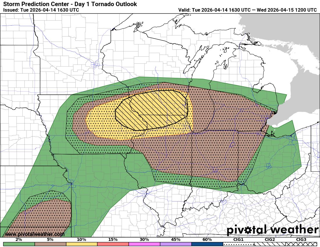
Justin

698 posts

Justin

Justin

@GamecockWorld

Katılım Haziran 2011
558 Takip Edilen52 Takipçiler
Kenny Wallace
Kenny Wallace@Kenny_Wallace·
That $10 million base salary that I said @TylerReddick deserves is getting more real by the WIN 🏁 What. A. Race 💯
English
37
2
177
8.6K
Justin
Justin@GamecockWorld·
@Hendrick9Team Hopefully there’s a couple caution flags towards the end of the race.
English
0
0
0
428
No. 9 Team
No. 9 Team@Hendrick9Team·
Chase got blocked in after the stop and he had to back up. Unfortunately, that puts us at 12th. #di9
English
40
14
106
11.8K
Justin
Justin@GamecockWorld·
@Hendrick9Team All pit boxes should be built big enough to were it’s impossible to get blocked in.
English
0
0
1
622
Justin
Justin@GamecockWorld·
@ryanhallyall There’s only been about 24 confirmed tornadoes so far. It will go up some once all the surveys are done.
English
0
0
3
1.4K
Ryan Hall, Y’all
Ryan Hall, Y’all@ryanhallyall·
Here's a timeline showing the 150 tornado & 300+ severe thunderstorm warnings from yesterday..
English
62
538
4.2K
326.3K
Justin
Justin@GamecockWorld·
@Mighty__Muffins @ConvChronicles Which doesn’t mean much if they go for a moderate, it would be for wind not tornadoes because these storms are going to cluster so fast.
English
0
0
0
30
Mighty Muffins
Mighty Muffins@Mighty__Muffins·
@ConvChronicles The fact they got a tor cig 2 now is wild. I mean damn. I think there is a chance now for the mdt but if they do it would probably before a wind upgrade.
English
1
0
0
194
Convective Chronicles
Convective Chronicles@ConvChronicles·
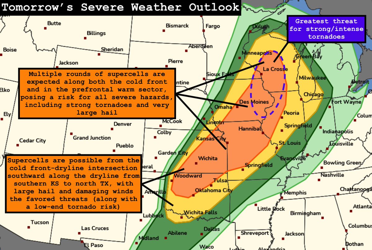
The potential for a widespread severe weather outbreak exists tomorrow (Friday, April 17) from the Great Lakes to the Southern Plains. The greatest threat for tornadoes (some strong/intense) looks to be within both the line of storms along the cold front and in any prefrontal supercell development across parts of Wisconsin, Iowa, and Illinois, perhaps also down into eastern Kansas/northwest Missouri. Very large hail and significant damaging winds are likely, as well. Supercells are also possible from the southern Kansas cold front-dryline intersection southward along the dryline. Very large hail and damaging winds should be the main threat, but a few tornadoes are also possible, especially if more discrete supercells can be maintained into early evening, when the low-level jet will strengthen and before the cold front crashes into them. I plan on making a forecast video tomorrow morning to cover this event in detail.
Convective Chronicles tweet media
English
1
19
185
10.4K
YallBot
YallBot@OfficialYallbot·
The Day 1 outlook has been updated. There is a Slight Risk of severe thunderstorms across New York and the Ozarks into the Mid-South.
YallBot tweet media
English
2
6
88
16.4K
Justin
Justin@GamecockWorld·
@BrianAllenWX Did a new County NWS pick up the storm that could be why.
English
0
0
0
4
Justin
Justin@GamecockWorld·
@SwannyHypno @MaxVelocityWX It shouldn’t be upgraded because if you look on the NAM model and click on spots in the tornado area for today there’s zero tornado looking hodographs.
English
0
0
0
68
Justin
Justin@GamecockWorld·
@MaxVelocityWX Convection Chronicles doesn’t understand why the SPC upgraded today because he couldn’t find any good hodographs on the models he pinpointed
English
0
0
0
194
Justin
Justin@GamecockWorld·
@MaxVelocityWX You mean a potential dangerous tornado setup. There’s no guarantee it’s going to be dangerously.
English
5
0
8
1.1K
Max Velocity
Max Velocity@MaxVelocityWX·
A dangerous tornado setup is unfolding across the Midwest today! 
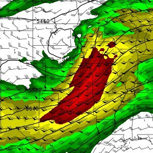
The highest tornado risk is centered from eastern Iowa into northern Illinois and southern Wisconsin, where a 10% CIG2 risk has been issues because conditions may support strong, potentially long-track tornadoes later this afternoon and evening. We will be covering this LIVE on YT and FB!
Max Velocity tweet media
English
12
60
554
29.1K
Justin
Justin@GamecockWorld·
@EricEstepp17 He got wrecked so you need to edit your post.
English
1
0
3
722
Eric Estepp
Eric Estepp@EricEstepp17·
RILEY HERBST MONSTER SABOTAGE
English
12
8
307
12.9K
Justin
Justin@GamecockWorld·
@Hendrick9Team Chase Elliott use to be really good at Bristol in the old car. He has truly struggled there in this new car. Heck even Byron is having a horrible day.
English
0
0
4
165
No. 9 Team
No. 9 Team@Hendrick9Team·
P18 with 50 to go. Chase has gone a lap down. #di9
English
14
8
38
3.2K
Justin
Justin@GamecockWorld·
@AkshayGadd18727 @EricEstepp17 Bowman is killing his career hopefully they replace it with Carson Hocevar he would probably win multiple races and have so many top tens and top five finishes.
English
0
0
1
85
Eric Estepp
Eric Estepp@EricEstepp17·
Safe to say Bristol is the one track SVG still hasn't figured out
English
16
6
334
10.7K
Justin
Justin@GamecockWorld·
@EricEstepp17 Bristol is now by far the worst track NASCAR races at this new car sucks there plus I wish they would just bulldoze the turns and rebuild them the way they were or turn it back to asphalt like it originally was.
English
1
0
12
856
Zak Morgan
Zak Morgan@ZakMorg79825576·
@Hendrick9Team Would’ve been 2nd if he picked the top Chase never been the brightest even with his talent
English
3
0
2
486
No. 9 Team
No. 9 Team@Hendrick9Team·
Chase settles into fifth after the restart. #di9
English
26
14
89
7K
Justin
Justin@GamecockWorld·
@spy_ballon @UConnWBB @ATT The refs didn’t call fouls on anybody both teams were beating the hell out of each other
English
0
0
4
372
chinese spy ballon
chinese spy ballon@spy_ballon·
@UConnWBB @ATT Complete bullshit from the refs in terms of foul calls. And South Carolina has no class whatsoever. UCONN will be back.
English
33
0
14
4.8K
Justin
Justin@GamecockWorld·
@ReedTimmerUSA If it wasn’t for the tornado in Michigan and the tornado in Illinois, Indiana, this would probably have to be the slowest start to tornado season I’ve ever seen.
English
0
0
4
515
Reed Timmer, PhD
Reed Timmer, PhD@ReedTimmerUSA·
A MULTI-ROUND SEVERE WEATHER OUTBREAK with #tornado potential is about to begin! 
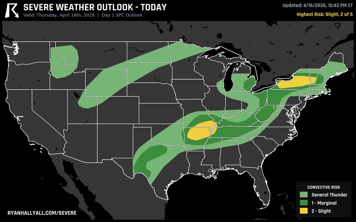
The greatest tornado threat will be along a warm front from southern Iowa and northern Missouri east to central Illinois. Short-range models show two distinct target areas: (1) near the surface low along the Iowa/Missouri border or (2) east along the warm front in central Illinois, peaking during 6-9 pm. Stay tuned to severe weather watches and warnings through tonight! Thank you @PettusWX
Reed Timmer, PhD tweet media
English
4
55
404
39.5K
Bob Pockrass
Bob Pockrass@bobpockrass·
If Chase Elliott wins, does Alan Gustafson get at least some of the credit?
English
157
34
1.3K
59.2K
Justin
Justin@GamecockWorld·
@bobpockrass No he’s horrible most of the time.
English
0
0
0
584