Sabitlenmiş Tweet
Haiden_wx
1.7K posts


Haiden_wx
@HaidenWx
in school for meteorology! spotter network chaser , tiktok lives and yt lives coming shortly
Katılım Ocak 2021
499 Takip Edilen142 Takipçiler

Unfortunately we have ultimately made the decision to disband FOT, our team members have grown busy with other things outside of weather, and simply put we are unable to continue creating consistent and accurate posts. We are deeply sorry
Thank You.
English
Haiden_wx retweetledi
Wanted to do a more in-depth analysis for this system so here it is.
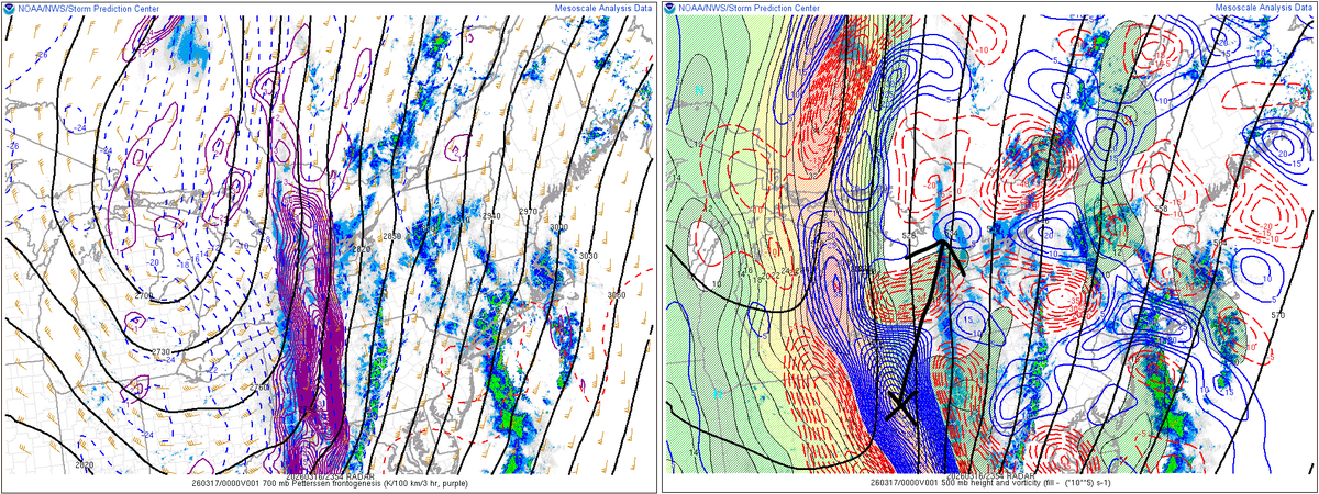
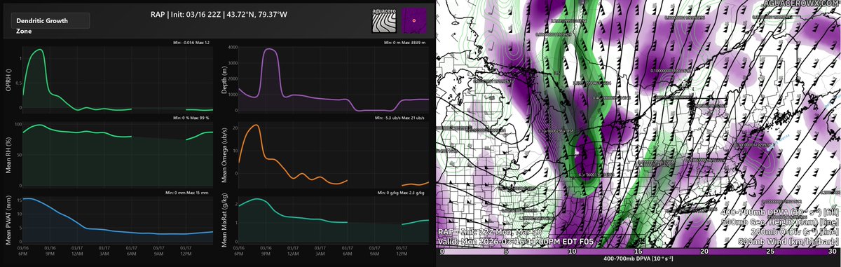
Eastern Ontario is the primary target. The large-scale setup mirrors what's described below for the GTA and Eastern Ontario, but prolonged snowfall period leads to higher totals, calling for 10-15cm. The GTA sits in a shorter window, limiting totals to 4-8cm despite the favorable mesoscale structure.
700mb frontogenesis is in place right now, with banding already organized along the front. This forcing moves out within the next couple of minutes, but it has effectively primed the corridor. This frontogenetical forcing drives the first window from 6-8pm, fueled directly by the isentropic lift already discussed.
Three distinct drivers follow in sequence, each fueled by isentropic ascent but peaking at different windows they don't stack, but they further prolong the snow.
The favorable DGZ window from 8-10pm takes over as the frontogenetical forcing moves out. Mean RH at 98%, mean omega at 21 µb/s, and 15mm PWAT with a 2.3 g/kg mixing ratio provides adequate moisture throughput. Snowfall rates are already verifying at 30 dBZ.
Large-scale ascent takes the wheel from 9-11pm as the 400-700mb differential PVA stack phases with 200mb Q-divergence, producing a vertically coherent ascent column. Combined with sustained upper-level vorticity advection and CAA-driven band organization, this is the most intense forcing window of the event. Snowfall rates are expected to reach generally 2cm/hr with locally intense bursts of 4cm/hr where banding is best organized — accumulations will stack up fast.
Overperformance comes down to the large-scale pattern and how it can further prolong snowfall and enhance rates. The negatively tilted trough, strong vorticity advection, and isentropic moisture feed have the potential to push duration beyond what models are currently showing — if the trough tilts further, it maintains forcing longer than guidance is capturing, leading to prolonged snowfall and additional accumulations.
#onwx #onstorm #Toronto


English
@ChasingWConnor Stay safe man next time u go there bring a knofe or firearm lots of weird animals
English

Haven’t posted anything yet bc I don’t want anyone getting stuck trying to get us but I am off the road on M41 about 30 miles SE Marquette.
!!!!THIS IS NOT AN EMERGENCY!!!!
We have enough water and gas to last until they plow tomorrow.

Connor Croff@ChasingWConnor
I’m 26 miles down M-41 southbound from Harvey. About 2 miles from Trenary. We are good on supplies good on gas the only thing we really need is a truck to pull us out. Have tow rope. Have had 5 pickup trucks drive past us in the last hour or so assuming a good vehicle for snow M41 is at least somewhat drivable on.
English

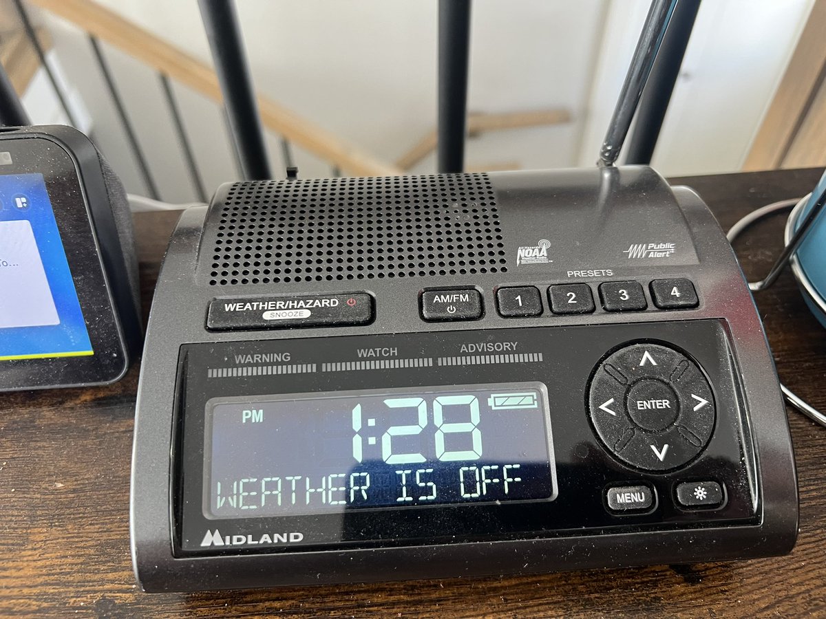
Well @HouckisPokisewx the day has come… I can confirm my weather radio is now offline… 😢 #SKstorm
English

@ATLAreaWx Gotta dig deep im like instant weather but im live year round since 2024 snow events to tornados accurete information etc
Only a few people coverage canada
English

Honestly, I don't remotely know how to get weather info in Canada anymore. Between the ECCC accounts being deleted & ECCC discontinuing radio alerts, it's embarrassing how a country w/ the 2nd most tornadoes in the world gets very poor weather coverage.
English
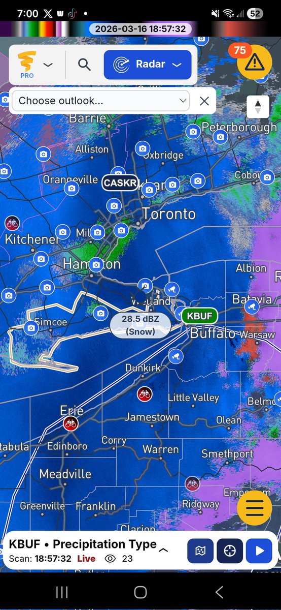


#ONStorm #ONwx So far it’s a snooze fest in Eastern Ontario with the potential severe risk today… 🥱
The environment is looking quite weak based on the current data. Very questionable if we see anything today. We’ll keep watching though to see if anything can get going.
But what we will definitely see is widespread snow spreading across Central and Eastern Ontario late this evening into the overnight hours as temperatures drop.
We’re working on a detailed forecast on the snowfall potential and will have it posted soon!
- Brennen

English

Live in northern Ontario and coping with this snowstorm today? I would love if you would tag me in your snow videos. I'm doing a story and there's nothing like footage from the locals. Let me know if I can credit you and use it on The Weather Network. Thanks in advance. #onstorm
English
Haiden_wx retweetledi
Working at The Weather Network is why I happily walked my dog this morning when it was 14C in Hamilton, and am leaving it for my hubby tomorrow when it's -5C. Work smarter, not harder. 🤓
English
Watch everyone be wrong about tomorrow and it actually verifies.
English


Haiden_wx retweetledi
#onstorm 3:54p SPECIAL WEATHER STATEMENT ENDED by Environment Canada
Stirling - Tweed - South Frontenac
Westport - Charleston Lake
instantweather.ca/2026/03/15/4Ly…
English