JCIChina

4.8K posts

JCIChina banner
JCIChina

JCIChina

@JCIChina

JCI provides market information and trade consultation to various organizations regarding China’s agricultural commodities.

People's Republic of China Katılım Mayıs 2014
1.4K Takip Edilen6.1K Takipçiler
JCIChina retweetledi
ggweather
ggweather@ggweather2026·
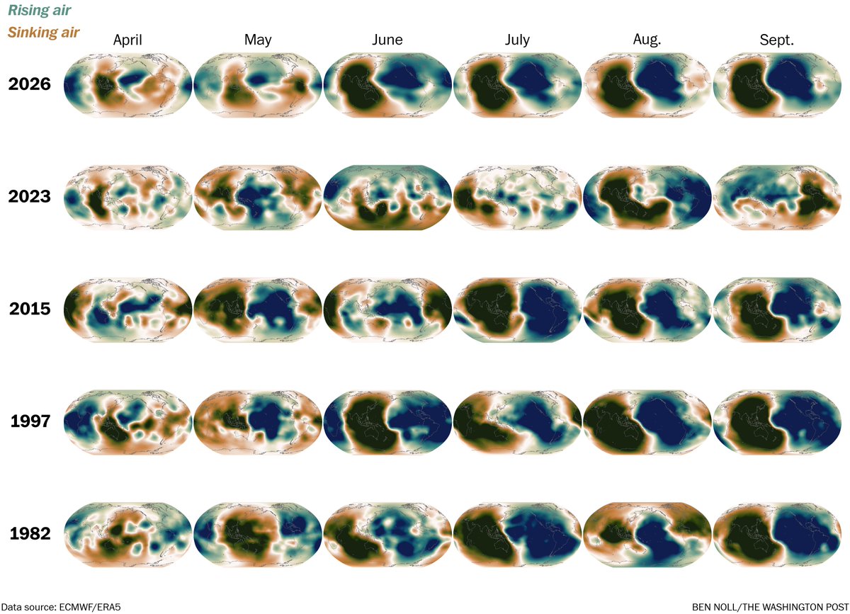
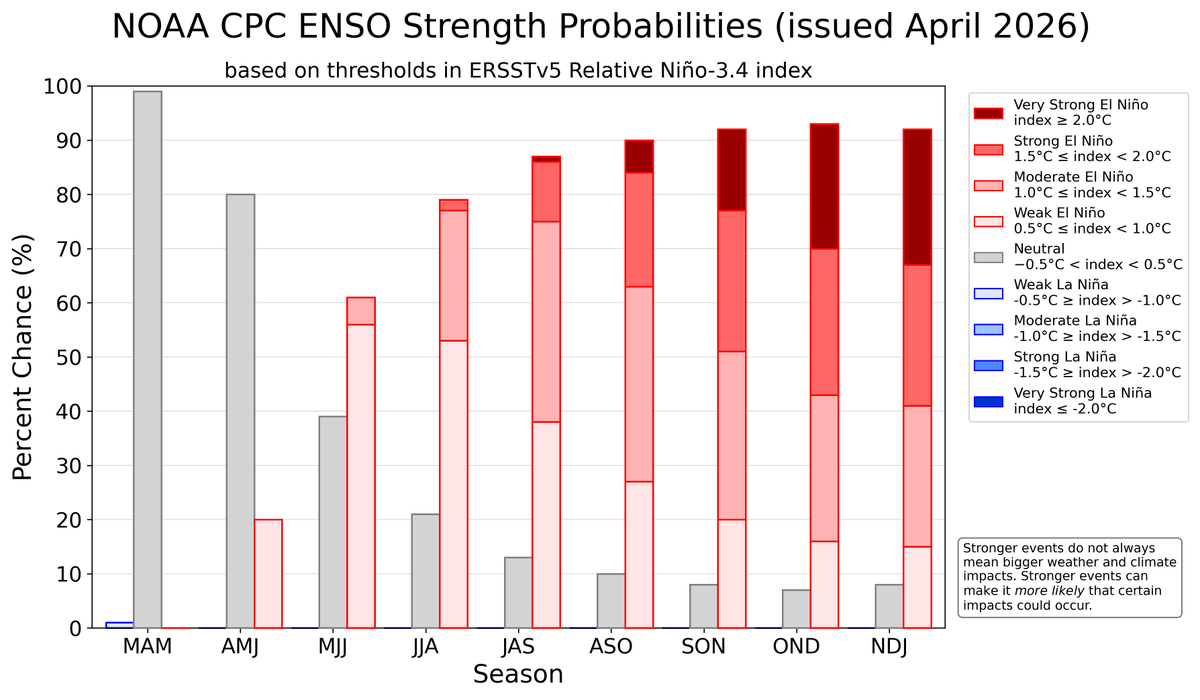
@cyclonicwx But even assuming we do get into the strong or very strong categories of El Niño, what does that really tell us 8 to 10 months in advance. Look at the huge variance of past events. I don't see a regions that has had the same signal for all 5 years.
ggweather tweet media
English
0
1
1
335
JCIChina retweetledi
Alex Boreham
Alex Boreham@cyclonicwx·
Some warming in the Atlantic thanks to a pattern shift towards -NAO. It will continue for a while, but it's got a big hole to climb out of to catch up with the (quite warm) global tropics
Alex Boreham tweet mediaAlex Boreham tweet mediaAlex Boreham tweet mediaAlex Boreham tweet media
English
2
10
80
14.9K
JCIChina retweetledi
Ben Noll
Ben Noll@BenNollWeather·
When it comes to El Niño, atmospheric changes matter just as much as changes in sea temperatures. That's because it's a coupled ocean-atmosphere phenomenon. Looking at velocity potential, which marks areas of rising air (green) and sinking air (brown) in response to warming and cooling tropical seas, a strong atmospheric El Niño response is forecast this year starting in June. That response is predicted to be quite similar to past big El Niño events, such as in 2015, 1997, and 1982. However, the atmospheric response in 2026 is forecast to be much different — and much stronger — than in 2023. These changes in the Walker Circulation arise from warm seas shifting from west to east across the tropical Pacific, which causes more thunderstorms in the east and fewer toward the west. This ultimately has flow-on effects on weather patterns across the planet due to changes in jet streams, as those thunderstorms release heat into the atmosphere.
Ben Noll tweet media
English
17
102
392
32.5K
JCIChina retweetledi
Ben Noll
Ben Noll@BenNollWeather·
This El Niño strength graphic from CPC is an excellent illustration of expected *relative index* trends. However, if this was calculated using the traditional index, the strong-very strong El Niño probabilities would probably be higher. The methodology shift this year, particularly ahead of a potentially intense El Niño, is something to consider when comparing El Niño forecasts from different sources. For example, while NOAA now uses the relative index, some other centers still produce El Niño outlooks based on a traditional 30-year climatology. I think seeing historic *relative index* forecast probabilities from the same times in 2023 and 2015 would more directly reveal how the predicted 2026 event compares. The relative index is better equipped to predict the onset of El Niño-like climate impacts and deal with warming seas than the traditional index. However, the traditional index informs just how unusually warm the El Niño monitoring region is compared to average and I think there's value in that too. I was involved in international panels that spurred the relative index toward being the operational one in New Zealand as well as other countries. Depending on your monitoring metric of choice, the projected strength of this El Niño will vary. Understanding these different indices and comparing apples to apples is important!
Ben Noll tweet media
English
0
5
26
6.4K
JCIChina retweetledi
Matthew Ferreira | MassachusettsWx
Matthew Ferreira | MassachusettsWx@MassachusettsWx·
The latest ECMWF SEAS5 forecast is calling for a significant number of members, indicating a Super Niño by September. Also, looking like a busier Pacific hurricane season?!👀
Matthew Ferreira | MassachusettsWx tweet mediaMatthew Ferreira | MassachusettsWx tweet mediaMatthew Ferreira | MassachusettsWx tweet media
English
9
57
286
15.4K
JCIChina retweetledi
Ben Noll
Ben Noll@BenNollWeather·
A super El Niño event in 2026-27 will be different than ones in 2015-16, 1997-98 and 1982-83, in part because of climate change. It's warmer now. That influences thunderstorm activity in the Pacific — which ultimately determines how El Niño influences weather patterns.
Ben Noll tweet media
English
4
55
219
29.3K
JCIChina retweetledi
Omar Jaén Lynch 
Omar Jaén Lynch @Kelme_boy·
Viendo los últimos pronósticos del ECMWF y NOAA, un Fenómeno de El Niño emergería en julio/agosto con ~62% de probabilidad. Nota al pie de página: Todos los gráficos pintan catastróficos para Ecuador.
Omar Jaén Lynch  tweet mediaOmar Jaén Lynch  tweet mediaOmar Jaén Lynch  tweet mediaOmar Jaén Lynch  tweet media
Español
21
180
508
90.4K
JCIChina retweetledi
GrainStats 🌾
GrainStats 🌾@GrainStats·
Thinking about fund positioning in ag markets as we head into this week in the hot markets - Corn, Soybeans, Wheat and Soybean Oil fund market length is there already, but on a percentage of open interest basis there is still room for funds to add here main thing to watch here is what Corn + Soy planting intentions are on Tuesday and if the fertilizer crisis has tempted some to switch to Soybean planting
GrainStats 🌾 tweet mediaGrainStats 🌾 tweet mediaGrainStats 🌾 tweet mediaGrainStats 🌾 tweet media
English
6
10
75
8K
JCIChina retweetledi
Karen Braun
Karen Braun@kannbwx·
🔥There's A LOT going on in agricultural markets right now. My Sunday & Monday mailings will include: ▪️RVO made simple (and what it means for soybeans) ▪️Super bulled-up speculators ▪️Pre USDA report analyses you won't see anywhere else Register via the link in my profile.
Karen Braun tweet mediaKaren Braun tweet media
English
4
11
79
17.4K
JCIChina retweetledi
Ethan Sacoransky
Ethan Sacoransky@blizzardof96·
Strong El Niño events, as forecast for next winter, are consistently associated with the warmest and least snowy winters in Canada. However, they have also been linked to unusual events, such as the January 1998 ice storm, which occurred during the 1997–1998 super El Niño.
English
3
7
56
5K
JCIChina retweetledi
World Climate Service
World Climate Service@WorldClimateSvc·
Daily Niño3.4 SST anomaly: 0.00 The transition is under way. However, the relative index (rNiño3.4) still has some distance to go before reaching neutral.
World Climate Service tweet mediaWorld Climate Service tweet media
English
5
20
77
4.5K
JCIChina
JCIChina@JCIChina·
Official Regulatory Policies Launched in China to Curb Annual Pig Production, breeding sow inventory may be further reduced to 36.5 million head
English
0
0
1
291