saketh modugu

50 posts

saketh modugu

saketh modugu

@ModuguSaketh

Katılım Haziran 2023
15 Takip Edilen3 Takipçiler
saketh modugu
saketh modugu@ModuguSaketh·
I tried to help dyson explaining this situation and support person gave me new label but still says i need to contact UPS in this cases . technically i need not contact dyson back as ups still says it is sending to dyson back. Is it not dyson team to investiage why its sent back?
English

0
0
0
15
saketh modugu
saketh modugu@ModuguSaketh·
@Dyson very bad support from dyson support team on call and chat. I initiated a return for a vaccum and i dropped of at UPS with the label given and ups still shows its on the way to Dyson with RFID scanned. But due to some mess with ups the package is back at my home.(1/2)
English
3
1
2
31
saketh modugu
saketh modugu@ModuguSaketh·
@EvanAndrewsWX which means cooler air in the northern counties help to diminish or reduce intensity for any afternoon storms ?
English
1
0
0
33
Evan Andrews
Evan Andrews@EvanAndrewsWX·
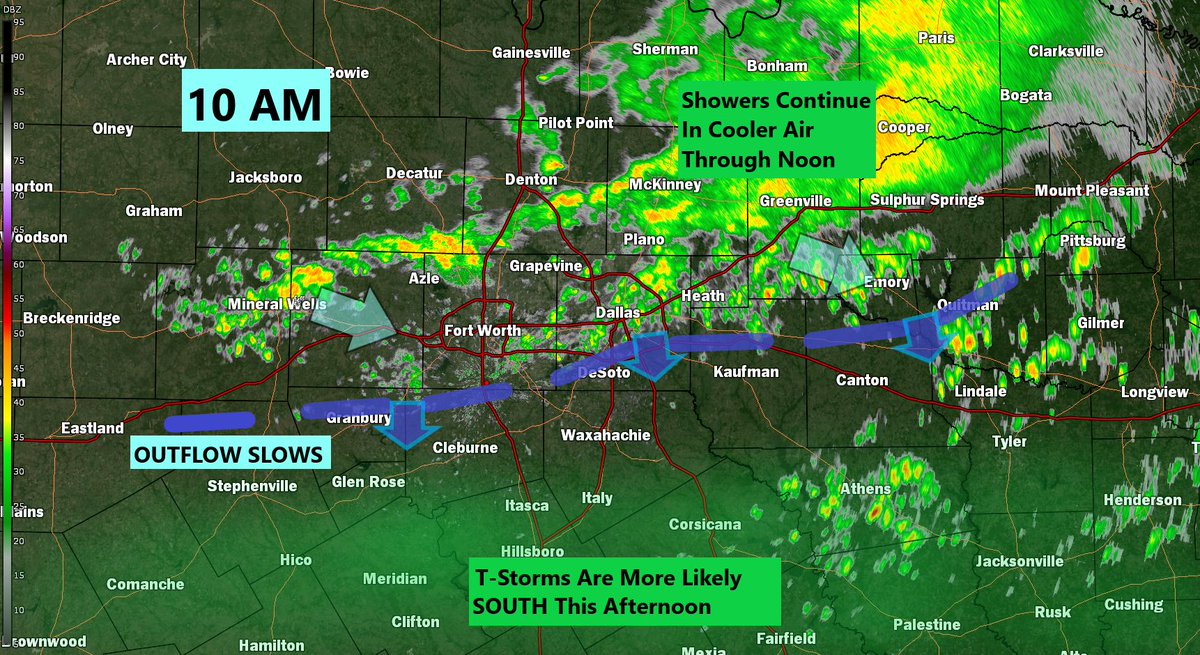
10AM: Tale of two forecasts. Our complex of showers (very few storms) has diminished although plenty still continue on the cooler side through noon as they move SE. That leaves southern counties heating up with a better chance to see some stronger storms as we move into PM hours.
Evan Andrews tweet media
English
1
1
18
987
Collin Myers
Collin Myers@collinmyerswx·
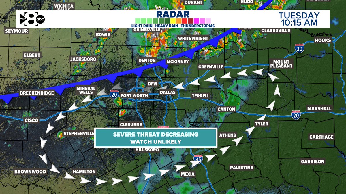
#DFW, 10:25am Update - Severe chances are decreasing steadily! Thank goodness these storms and the front are moving through faster. I can’t rule out a strong storm or two in the next few hours, but this trend is our friend. @wfaa #txwx #dfwwx
Collin Myers tweet media
English
3
4
60
11.5K
saketh modugu
saketh modugu@ModuguSaketh·
@EvanAndrewsWX so if outflow is going south --will that make north counties more stable?
English
1
0
0
66
Evan Andrews
Evan Andrews@EvanAndrewsWX·
9:30AM: Little more complex situation out there as an outflow boundary has moved into NTX away from the front. It's generating shower/storms (non-severe) on it's trip and is now into northern parts of the Metroplex. Some heavy rain and lightning...and pocket change hail possible.
Evan Andrews tweet media
English
2
2
34
1.6K
Falcon Storm Chasing
Falcon Storm Chasing@FalcnStormChase·
Convective evolution is largely on cue. Rapid upscale growth is underway with supercell clusters and multicells maturing at peak heating. #TXwx #FALCONWX 4:05 PM update
Falcon Storm Chasing tweet media
English
2
3
22
554
Evan Andrews
Evan Andrews@EvanAndrewsWX·
5 PM: Now we start watching since it's "that time". The cold front has made a little better progress...now to Lewisville-DFW-FTW, so if we are to see some spotty storms they would be along or ahead of that front. Still a hail risk with any that form, but only see about 20% now.
Evan Andrews tweet media
English
1
1
22
1.6K
Collin Myers
Collin Myers@collinmyerswx·
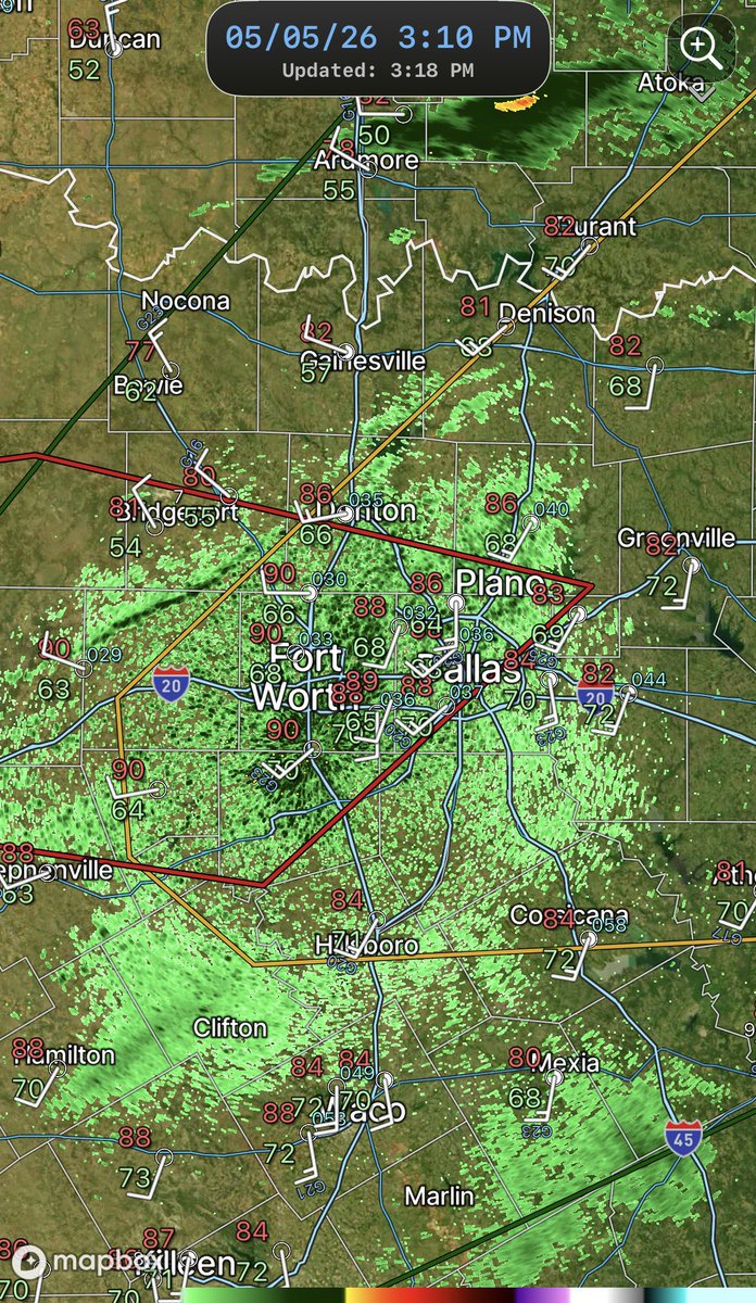
3:20pm - Frontal boundary entering #DFW. Temps nearing 88-90°F and dews nearing 66-70°F across the board. A Severe Thunderstorm Watch might be needed soon, also. Watching closely. #dfwwx #txwx
Collin Myers tweet media
English
2
1
16
1.9K
Collin Myers
Collin Myers@collinmyerswx·
High-resolution models are firing up a few storms again today around midday. Some of these might be strong with some gusty winds and small hail. This is not like the setup yesterday. The atmosphere doesn't have the potential it did yesterday. @wfaa #txwx #dfwwx
Collin Myers tweet media
English
1
5
27
4.2K
saketh modugu
saketh modugu@ModuguSaketh·
@collinmyerswx Everyone in McKinney is dead, but the Bubble has never looked more vibrant. 💀🛡️
English
1
0
1
2K
Collin Myers
Collin Myers@collinmyerswx·
The McKinney bubble has power. That is a serious dome. Maybe it’s the temps of 101,115°
English
27
39
623
56.8K
saketh modugu
saketh modugu@ModuguSaketh·
@MatthewCappucci are you still sticking with this? i hardly see any hail reports between north of 380 over dfw counties
English
0
0
0
107
Matthew Cappucci
Matthew Cappucci@MatthewCappucci·
The MUMBO ZONE includes areas near, and especially just north of, the DFW MetroPlex this evening. My greatest concern is between Highways 380 and 82. Not all hail will be giant. But the strongest storms will be capable of very large to giant hail. #Mumbology
Matthew Cappucci tweet media
CompWx@CompWx

@MatthewCappucci Mumbos?

English
5
3
45
8.8K
saketh modugu
saketh modugu@ModuguSaketh·
@collinmyerswx @ryguyMIZ are we still anticipating new storms over collin? givem 4/5 and many assuming strong cells over north of 380 not sure if we can take a breath
English
0
0
0
58
Collin Myers
Collin Myers@collinmyerswx·
@ryguyMIZ SPC is generally the best. So far, it looks like hail size was slightly off and coverage was maybe a bit overdone. Still early.
English
2
0
5
430
Falcon Storm Chasing
Falcon Storm Chasing@FalcnStormChase·
@ModuguSaketh It’s adjusting to ongoing convection and surface obs with each run. So exact placement of simulated reflectivity will be all over the place until it can pick up the location of the boundaries.
English
1
0
0
36
Falcon Storm Chasing
Falcon Storm Chasing@FalcnStormChase·
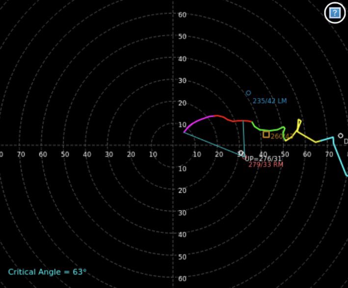
Fairly straight hodographs in the main risk areas expected this afternoon. The tornado risk should remain lower end however given the amount of instability and any outflow boundaries any right moving storm that could propagate southeast would have a tornado risk.
Falcon Storm Chasing tweet mediaFalcon Storm Chasing tweet media
English
4
2
18
1.3K
Collin Myers
Collin Myers@collinmyerswx·
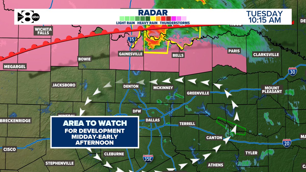
10:20am - One severe-warned supercell continues along the Red River to the east, hugging the frontal boundary. Expect storms to develop in the next 2-4 hours in our central #DFW counties with all hazards, but primarily a large hail risk. Stay apprised. @wfaa #txwx #dfwwx
Collin Myers tweet media
English
1
4
49
4.3K
Collin Myers
Collin Myers@collinmyerswx·
50,000 feet up.
Collin Myers tweet media
English
1
4
42
990
saketh modugu
saketh modugu@ModuguSaketh·
@FalcnStormChase Are you expecting intense storms below dry line? And can they move towards dryline and above
English
0
0
0
17
Falcon Storm Chasing
Falcon Storm Chasing@FalcnStormChase·
The DL orientation seems unfavorable for isolated supercell development late this afternoon and evening. However any updrafts that can sustain themselves and fully mature could still pose all hazards severe risk. Can’t let guard down just yet.
Falcon Storm Chasing tweet media
English
3
0
14
823
Evan Andrews
Evan Andrews@EvanAndrewsWX·
@ModuguSaketh The observations are plotted here but the number on the bottom left s the dewpoint. you can see a thin line on the radar as well.
Evan Andrews tweet media
English
1
0
0
23
Evan Andrews
Evan Andrews@EvanAndrewsWX·
Monday PM-eve: Not a totally storm-free forecast. late PM we expect the DRY LINE to be near DFW (90s west & north) with muggy 80s east and south. There is the risk (20%) we get a couple of cells to pop with a hail risk (pocket-change) and some gusty winds east of that dry line.
Evan Andrews tweet media
English
4
2
30
2K
Collin Myers
Collin Myers@collinmyerswx·
@DantinMorganwx @ModuguSaketh @wfaa That instability is partly strong due to the inversion layer. Dryline is just a physical divide between dry and moist air. You would have to hit the convective temperature to break through. CT’s are very high.
English
3
0
1
178
Collin Myers
Collin Myers@collinmyerswx·
2:30pm #DFW Update: here’s the current convective outlook. Our thinking hasn’t changed. The CAP is still very strong. The best chance for active weather is in the 3/4 zones, late. Hail is the primary risk. DFW has a conditional threat if storms form closer. @wfaa #dfwwx #txwx
Collin Myers tweet media
English
3
6
47
9.3K