
Nick Psomaras
2.2K posts
Nick Psomaras
@NickyPsomaras
Rutgers University || Weather Forecaster || Yankees || NY Rangers
Ewing, NJ Katılım Kasım 2014
266 Takip Edilen138 Takipçiler

I’ve never believed a shot was going in more than that Vandy half court shot
English

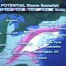
March 5-6 is a cursed day for Mid-Atlantic snow lovers.
Imagine going to bed the night before expecting a major snowstorm only to wind up with nothing.
For some, that happened in 2001 and 2013. The 2001 case is probably the worst bust of all time given the stakes.
English
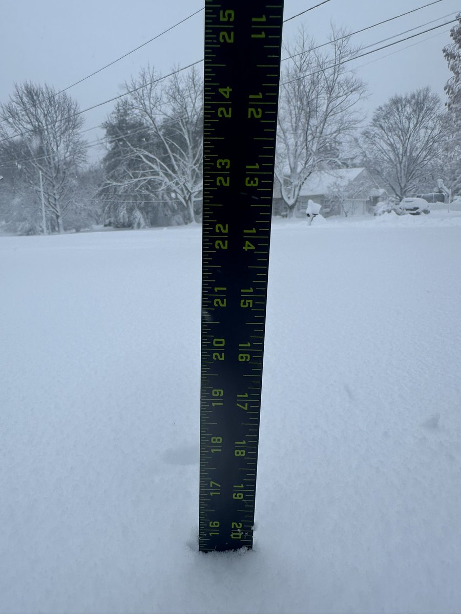
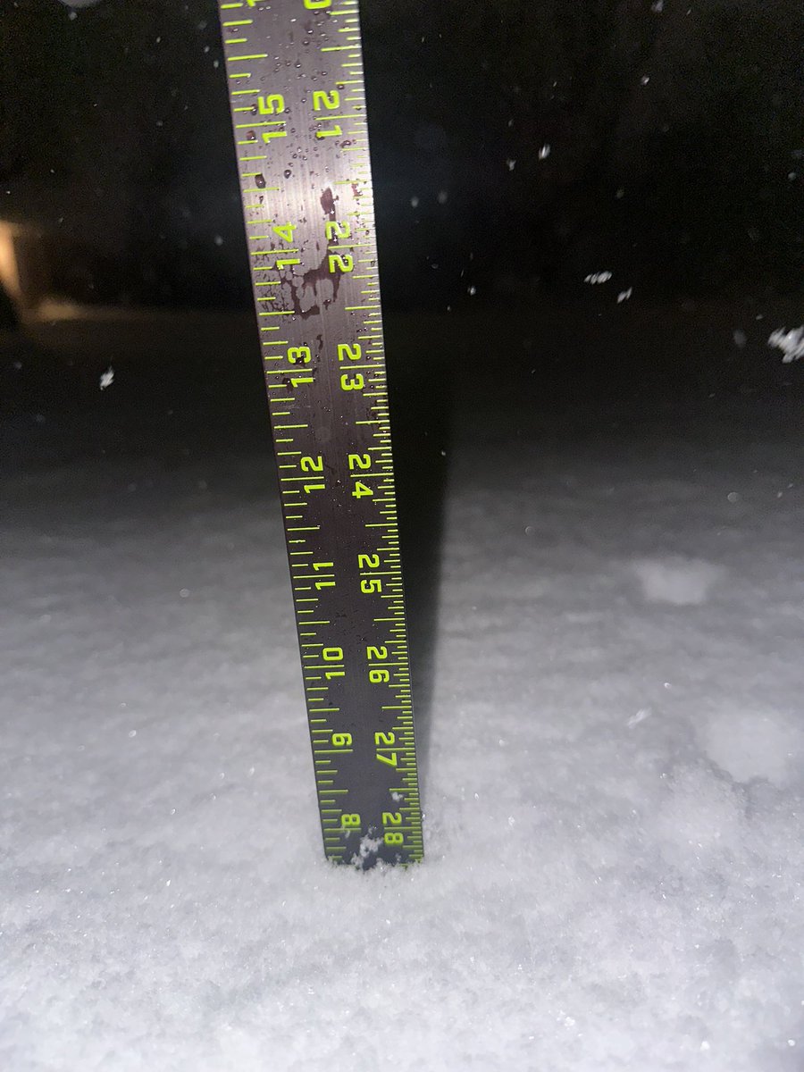
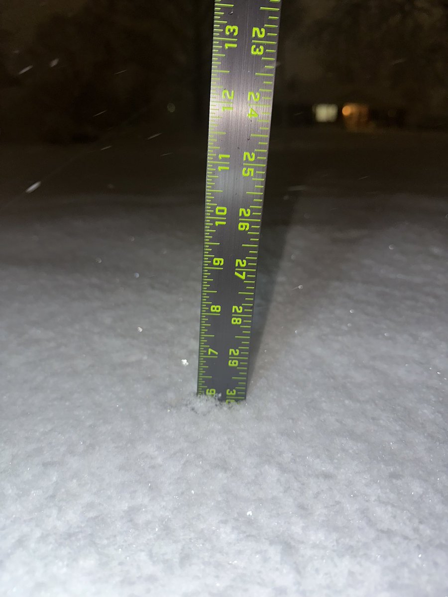
@burgwx I’m in western Mercer county (Ewing) and got around 16.5”. I guess they were in slightly better radar returns that gave them 3-5” more than I did.
English

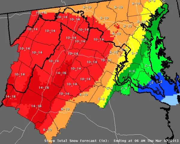
Question for anyone from Bucks County, PA (specifically the southeast part of the county) - is anyone able to confirm that over 20 inches of snow fell?
Multiple reports over 20" were received in that area, but seem to be slightly out of sync with nearby observations.
- Morrisville (21")
- Fairless Hills (20.5")
- Lower Makefield Township (22.1")
- Langhorne (22.3")
English
Ewing, NJ (08638): 0.8” of new snow at 6:35 AM
Snow has stopped during time of report.
@NWS_MountHolly

English
@WxmanFranz I was in subsidence multiple times here in Mercer and got 16”. Testament to how powerful this storm was.
English

Crazy we had a few lulls, weaker areas of precip at the coast until the end but still had 19” in Forked River (not white board measured, compacted & was at 12:45pm). If only it was more consolidated then those higher amounts could have been achievable #NJwx
Joe Martucci: Meteorologist@JoeMartWx
❄️A top 10 NJ snowstorm 💣A bomb cyclone. 😲A legendary 30 hours, all on radar. Via: Jared Rennie, NOAA's National Centers For Environmental Information @jjrennie Data Source: @NOAA Sparkable boosts your brand with expert marketing, SEO, and web—ignite it at sparkable.com .
English

Well, another storm in the books. This was a fun one to track with lots of rapid changes and major questions to figure out.
Thoroughly enjoyed all the questions and interactions, and I appreciate everyone that sent in reports & photos.
A pretty standard “big storm” for Boston, but a historic storm for SE MA. Interested to see what records get verified.
Onto the next!

English

It may have just missed us here in DC, but the Blizzard of 2026 will be remembered for a long time in the coastal Northeast!
What a storm.
English
15.5” as of 7:45 AM: Ewing, NJ (08638)
Light snow still falling at time of report
@NWS_MountHolly
English


Sorry, I just can't keep up with pinpoint snow accumulation questions with this storm.
English

What's nuts is I disappeared for a while this evening, and I come back to questions of why other sources are way lower than what we projected at 5:00pm.
I've got news for you...we might not be high enough. Some of these models are straight up choosing violence this evening.
Coplay, PA 🇺🇸 English
@nynjpaweather Wrong period. 22nd - 23rd is what we’re watching
English

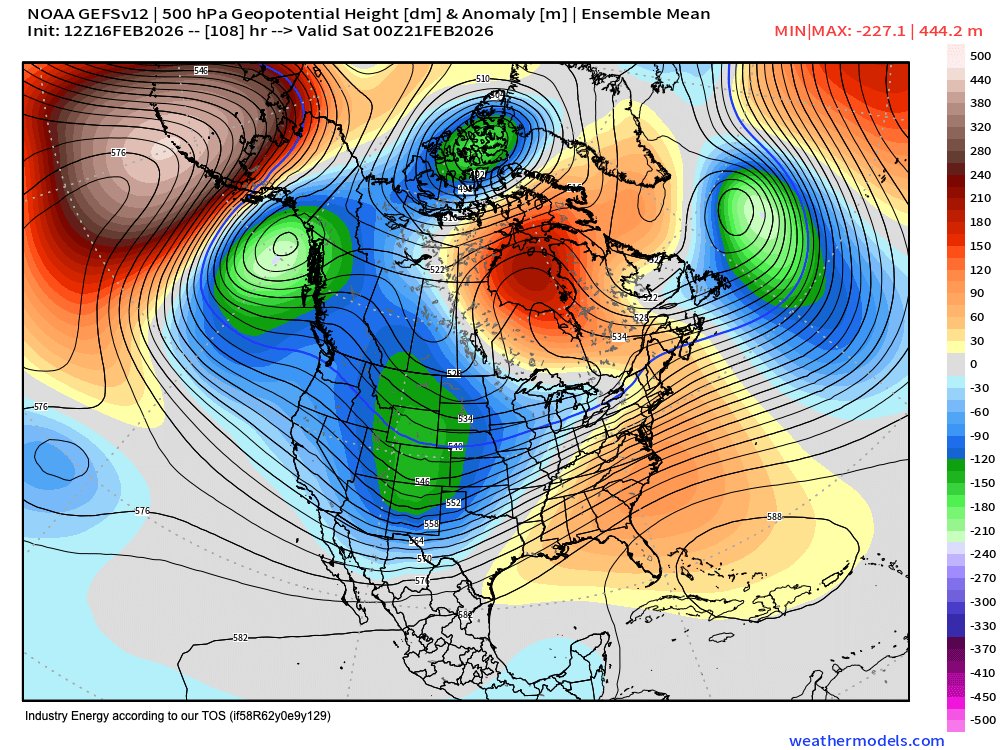
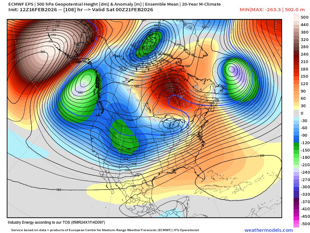
Just so we all understand, for those who want to learn, this 500 MB pattern on the EPS and GEFS is NOT supportive of any type of major snowfall for the northern Mid-Atlantic. New England? Maybe. Especially for the mountains.
But for Philadelphia and New York City? Let me save you a lot of time here, this is a late-forming Miller B type of setup, with secondary low take over around Long Island to the Gulf of Maine.
Use this information any way you like. If you like to ignore it, so be it. Thank you!
English
𝙁𝙞𝙣𝙖𝙡 𝙪𝙥𝙙𝙖𝙩𝙚 𝙬𝙞𝙩𝙝 𝙩𝙝𝙞𝙨 𝙚𝙫𝙚𝙣𝙞𝙣𝙜'𝙨 𝙬𝙞𝙣𝙩𝙧𝙮 𝙚𝙫𝙚𝙣𝙩:
View it here~> epawaweather.com/weather-alerts/
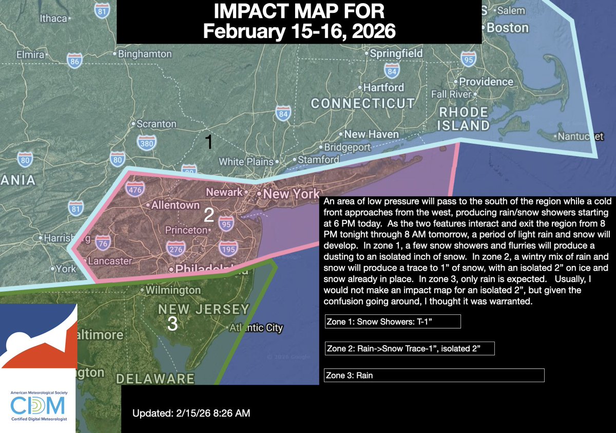
Some minor changes from yesterday, but overall a minor event for most. Watch for slippery roadways if traveling this evening.

English
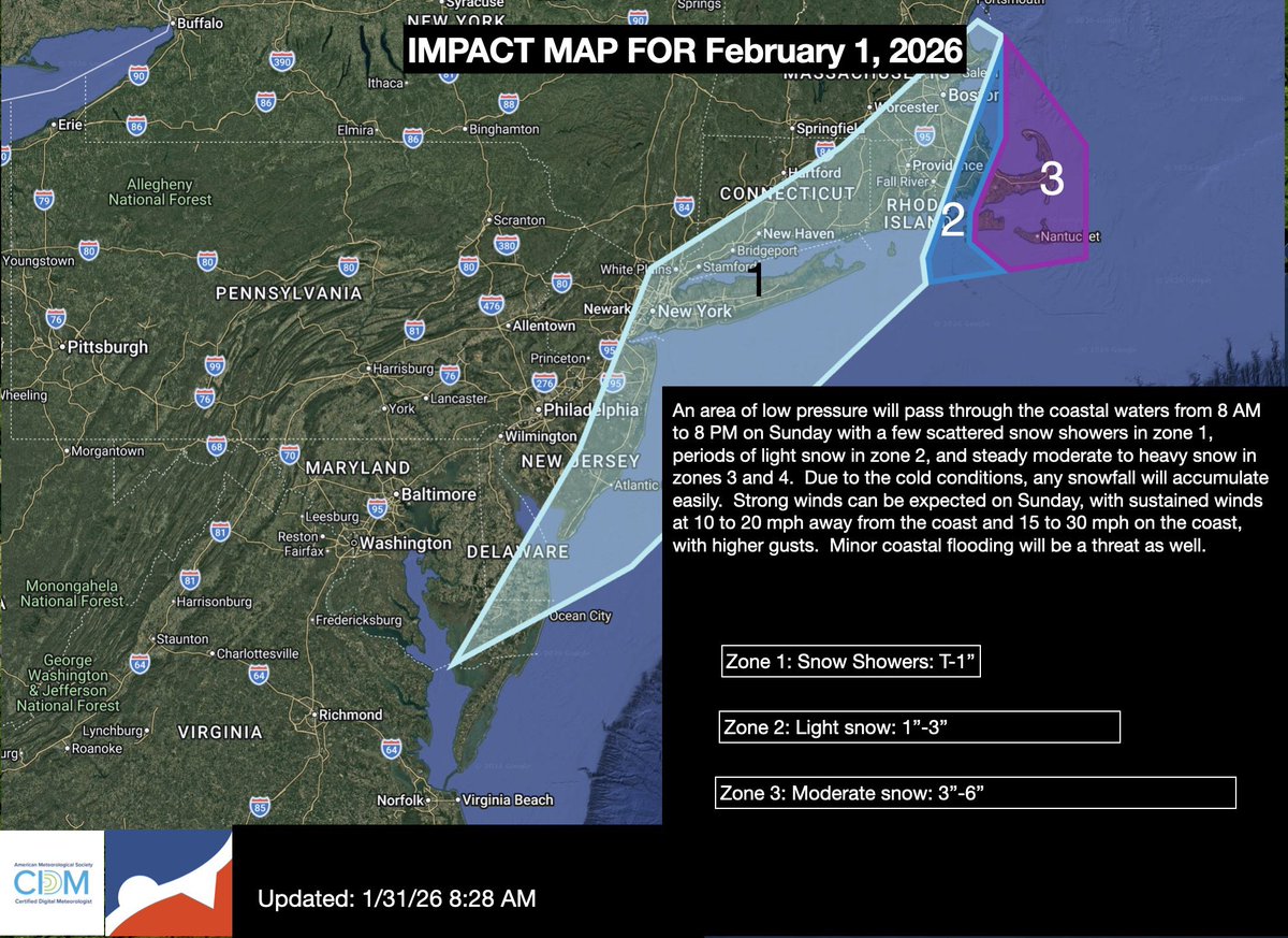
@nynjpaweather Genuinely curious. Why do you continue to express so much disgust about issuing a map for this event?
You made a map back on Feb 1 for coastal NJ-Long Island flurries…Wouldn’t tonight’s snow be more “impactful” for NY-NJ-PA?
It’s okay to make maps for C-2 inches lol
English
No changes, but updated the wording on timing to today.
English
@nynjpaweather *Taking the night off for Valentines*
Immediately breaks away to screenshot models. Weird man, very weird.
English

@YankeesFiles Game 1 catch in foul territory?? Verdugo is a forever hero if Boone didn’t bring Nestor in.
English

This is the only cool thing Alex Verdugo ever did, basically
English