Peter Corman

13.9K posts

Peter Corman banner
Peter Corman

Peter Corman

@PeterC428

MU'27 | Project TILTTING | RFK Racing Fan |

Katılım Mayıs 2017
776 Takip Edilen791 Takipçiler
Sabitlenmiş Tweet
Peter Corman
Peter Corman@PeterC428·
BIG LOWERING ON A TORNADO WARNED SUPERCELL NEAR HARRISBURG PA #pawx
Peter Corman tweet mediaPeter Corman tweet media
English
3
20
112
5.7K
Peter Corman retweetledi
NASCAR
NASCAR@NASCAR·
Be like Biff. All three @RFKracing cars will run special paint schemes in honor of Greg Biffle this weekend at @TooToughToTame.
NASCAR tweet media
English
16
210
1.7K
29.2K
Peter Corman retweetledi
Cameron Nixon
Cameron Nixon@CameronJNixon·
Anyway here's a map of all EF2+ tornado soundings for select locations across the U.S.
Cameron Nixon tweet media
English
28
52
386
16K
Peter Corman
Peter Corman@PeterC428·
Opened up @chase_archive to see that my chase from last week was already put in there. Shoutout to whoever submitted it already!!
Peter Corman tweet media
English
1
2
12
1K
Peter Corman
Peter Corman@PeterC428·
Give me a storm in this environment, and I'll cook up another banger picture.
Peter Corman tweet media
English
0
0
20
681
Peter Corman retweetledi
WeatherFront
WeatherFront@WxFront·
Easily a top 5 radar loop in WF history. The atmosphere is incredible.
English
10
81
667
44.9K
Peter Corman
Peter Corman@PeterC428·
Severe weather may return to the Central/Midwest regions of the United States this weekend, mainly focused on Sunday with a longwave trough. While the trough is there, notable timing and intensity differences result in different outcomes throughout the models.
GIF
GIF
English
3
2
15
578
Peter Corman
Peter Corman@PeterC428·
Moisture return is quite uncertain at the time, especially with the difference in model solutions. However, if we can get upper 50s dews into the Midwest with the trough, severe weather could make an early but brief return to the US.
GIF
GIF
English
0
0
1
114
Peter Corman
Peter Corman@PeterC428·
These differences primarily arise from the GFS/ICON, which is significantly slower at lower levels (850mb/sfc) than the other models. I hesitate to lean towards these models, and I think it's quite an outlier at the moment.
GIF
GIF
GIF
GIF
English
1
0
1
108
Peter Corman
Peter Corman@PeterC428·
Radar vs the shot March 11th, 2026 Harrisburg, Pennsylvania
Peter Corman tweet mediaPeter Corman tweet media
English
3
6
56
2.3K
Peter Corman
Peter Corman@PeterC428·
Thank you Google AI.
Peter Corman tweet media
English
0
0
2
172
Peter Corman retweetledi
Convective Chronicles
Convective Chronicles@ConvChronicles·
Meteorological breakdown of the Kankakee, IL, tornadic supercell from March 10 is coming later this week, complete with special guest! We'll be taking an in-depth look at the changes in storm behavior that led to significant tornado production from NE Illinois well into NW Indiana, as well has how this storm was able to produce gargantuan hail and significant tornadoes simultaneously. Stay tuned!
Convective Chronicles tweet media
English
14
32
293
9.8K
Peter Corman
Peter Corman@PeterC428·
@GumryWX You're all good. I thought I remembered it incorrectly, but I couldn't remember, but I knew for sure the 0-3km vectors were just as atrocious as well. Thank you
English
0
0
1
14
Isaiah Montgomery
Isaiah Montgomery@GumryWX·
Sorry, I was at lunch and I didn’t want to read that #essay The 0-3 km shear vector is usually the one referenced in literature, and they were absolutely atrocious. I also pointed this out and I’m glad I was able to catch it. The only QLCS that looked like it was remotely strong was the NW-SE oriented segment near DC. It was just extremely dreadful
English
1
0
1
14
Peter Corman
Peter Corman@PeterC428·
With yesterday's event now over, I think it's time to dive into a bit of a post-mortem and analyze my thoughts from a few days ago. While it certainly failed some expectations, it wasn't a total "bust" that some people implied. Let's talk about it!
Peter Corman tweet mediaPeter Corman tweet media
Peter Corman@PeterC428

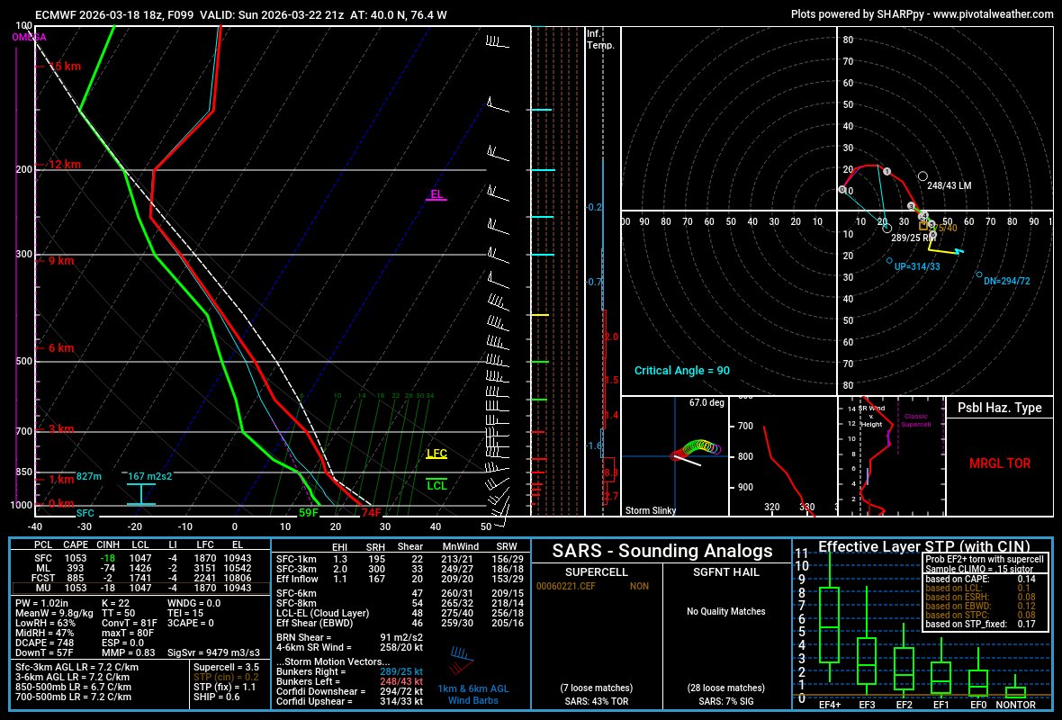
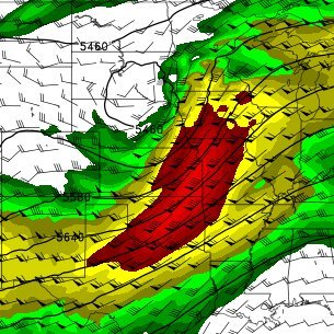
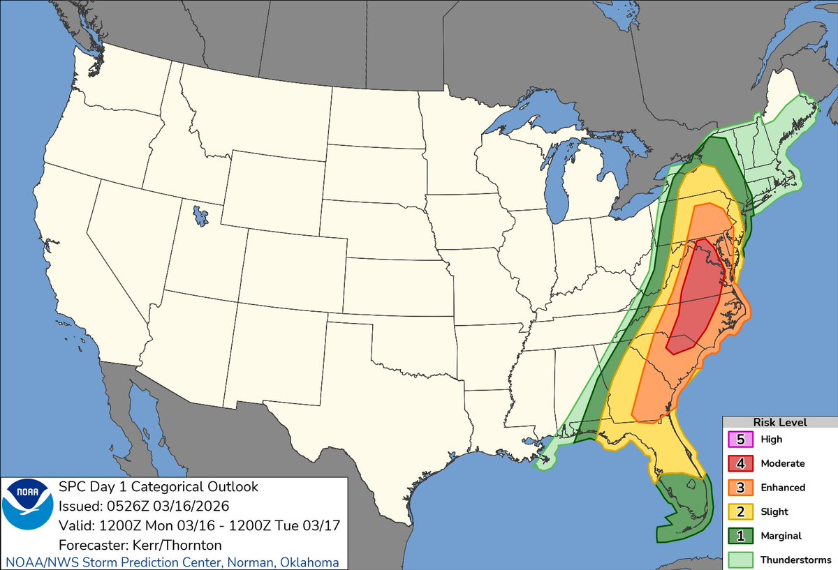
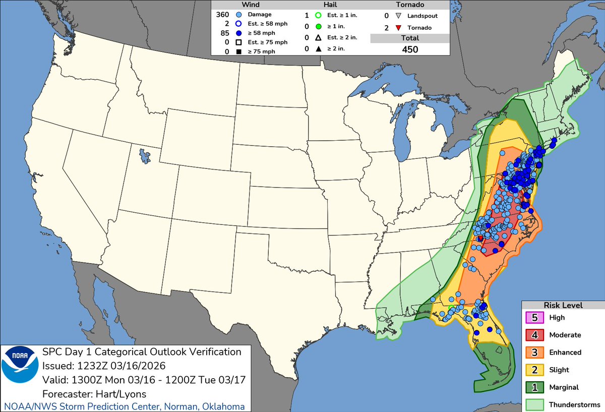
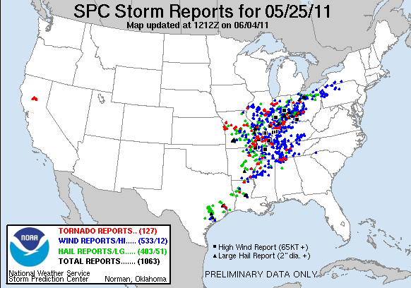
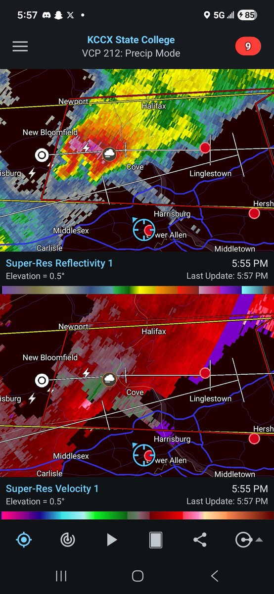
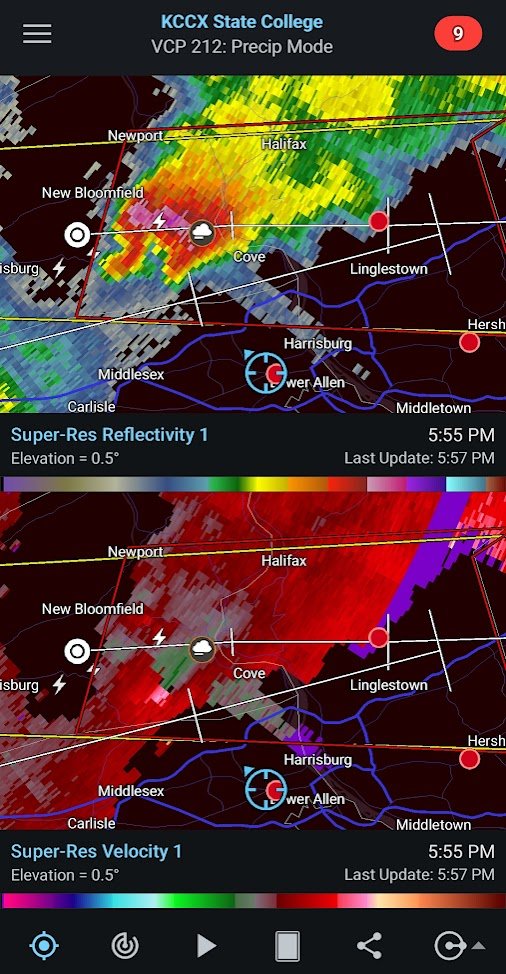
A potent severe weather event is on tap for the Mid-Atlantic region on Monday, with a rare D4 30% from Eastern North Carolina into Virginia and Southern Maryland, with a 15% extending from South Carolina into the Lower Susquehanna Valley. Let's take a deep dive into the event...

English
1
0
9
377
Peter Corman retweetledi
Adam Moore
Adam Moore@AdamMooreWX·
Announcement Time: I have been sitting on this for a few weeks now but I think it’s time to share... I’m excited to announce that I accepted a job as an SAU Analyst at the Virginia Department of Emergency Management (VDEM). (1/2)
Adam Moore tweet media
English
13
1
82
3.5K
Peter Corman retweetledi
Cameron Nixon
Cameron Nixon@CameronJNixon·
Side-by-side of events tracks and storm reports. This is not an operational product, but we're getting there! Look forward to more of these :)
Cameron Nixon tweet mediaCameron Nixon tweet media
English
13
19
197
9.4K
Peter Corman
Peter Corman@PeterC428·
You could argue a tornado "bust" more than anything, but I imagine we'll have at least a few tornadoes confirmed over the next few days that will make the 15 Cig 1 a little less bare. Those are just my thoughts, and happy to discuss anything further!
English
0
0
2
71
Peter Corman
Peter Corman@PeterC428·
At the end of the day, forecasting is challenging, especially in an era where data-sparse regions are quite common. The threat was absolutely there, and I do think the MDT was warranted. While it didn't verify one, and the tornado risk underperformed, it was far from a bust.
English
1
0
2
74