Ethan

3K posts

Ethan banner
Ethan

Ethan

@RadarOmegaEthan

DM me “tomato” for a surprise

Stow, OH Katılım Aralık 2022
328 Takip Edilen138 Takipçiler
Ethan
Ethan@RadarOmegaEthan·
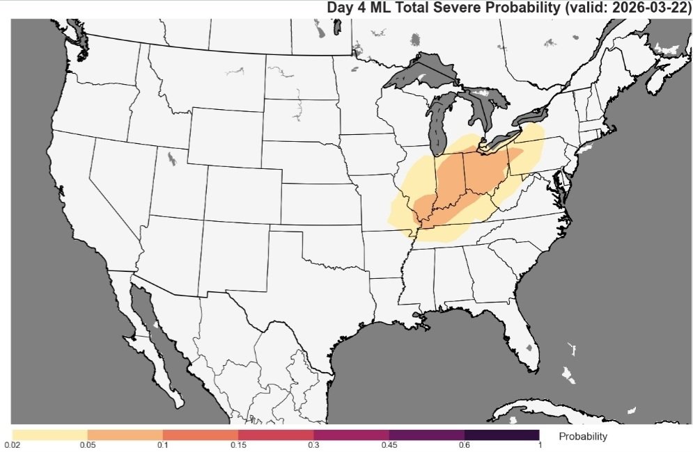
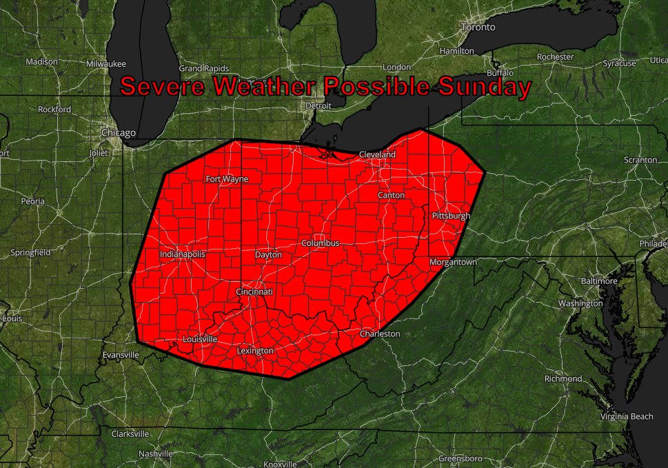
@ryanhallyall Is Akron and Cleveland at risk for some large hail?
English
0
0
0
630
Ryan Hall, Y’all
Ryan Hall, Y’all@ryanhallyall·
Sunday's looking active. Level 2 risk across the Ohio Valley with supercells and large hail likely from southern Illinois into western Pennsylvania. Storms fire in the afternoon and could merge into a damaging line by evening.
Ryan Hall, Y’all tweet media
English
7
49
349
21.1K
Ethan
Ethan@RadarOmegaEthan·
@wx_macomb I’m in Northeast Ohio and it looks increasingly likely more so we and further south see something but not ruling out lower Michigan either
English
3
0
1
59
⚡Macomb Wx⚡
⚡Macomb Wx⚡@wx_macomb·
Some severe weather MAY try to sneak into central lower/ south east MI here on Sunday as some models are pushing in moist dews and some cape. #miwx
English
1
1
2
107
Ethan
Ethan@RadarOmegaEthan·
@PezexWx How does Sunday continue to look?
English
0
0
0
18
Ethan
Ethan@RadarOmegaEthan·
@PettusWX OOOOO WHAT IS THIS CALLED?? I need it NOW lmao😂
English
0
0
0
32
James Pettus
James Pettus@PettusWX·
Forecast Master will be down until April 1st, as I work on migrating the new features onto the servers.
James Pettus tweet media
English
6
4
81
7.3K
Zach Egleston
Zach Egleston@OHWXisweird·
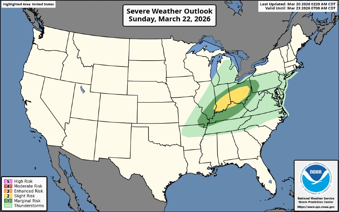
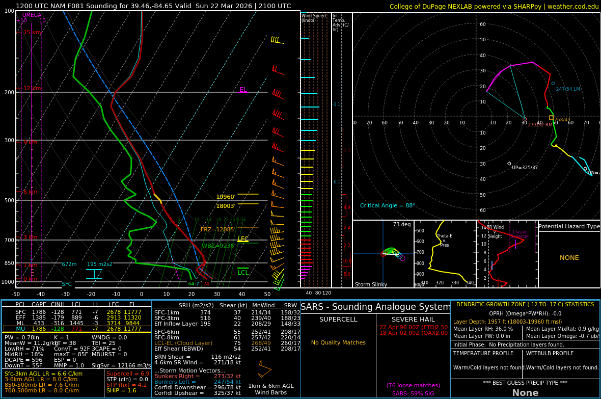
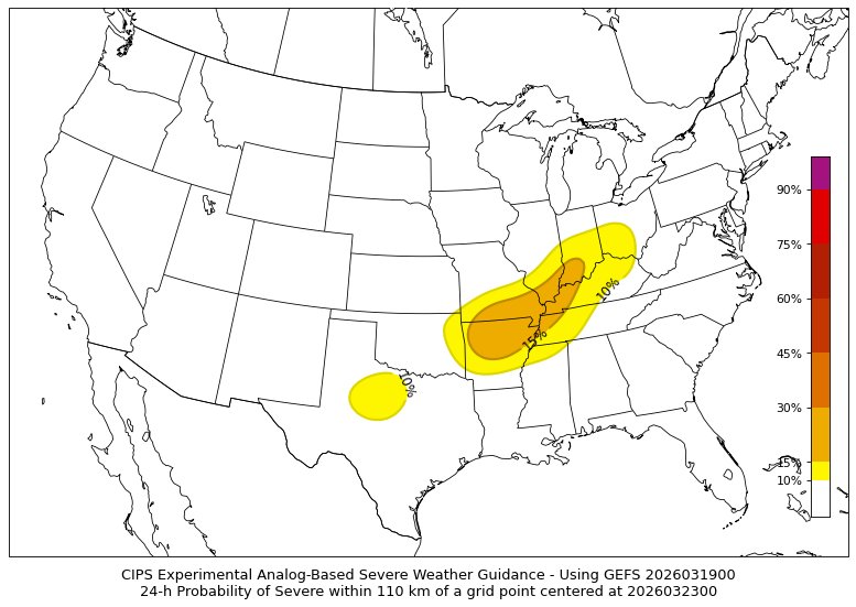
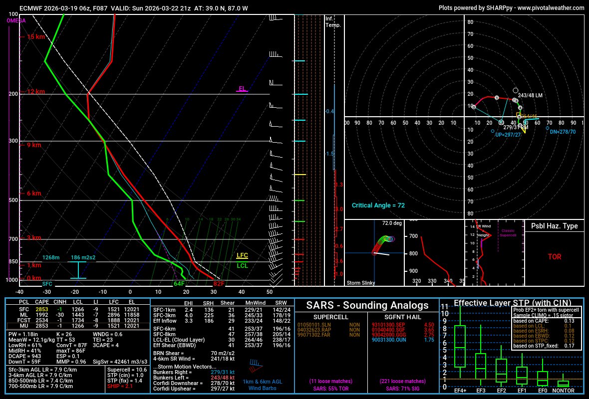
Oh wow what a nice environment for severe weather, I wonder what the skew-t looks like...
Zach Egleston tweet mediaZach Egleston tweet media
English
6
3
95
25.8K
YallBot
YallBot@OfficialYallbot·
👀 Watching Sunday closely. The SPC is highlighting a setup for potential strong to severe thunderstorms across the Ohio and Tennessee Valleys as a strong cold front clashes with a warming airmass. We're breaking down the models LIVE on YouTube and X! 🌩️ #OHwx #TNwx
English
2
1
4
590
Ethan
Ethan@RadarOmegaEthan·
@Sam362899039981 To be honest, this looks like a ring of fire MCS
English
1
0
1
60
Ethan
Ethan@RadarOmegaEthan·
@OfficialYallbot Have you seen the sneaky Sunday setup showing on the weather modeling for up here in the Ohio / PA vicinity? What are your thoughts?
English
0
0
0
63
YallBot
YallBot@OfficialYallbot·
Honestly, looking at the radar is wild today. The entire country is dealing with extreme heat, floods, or 80+ MPH winds... and then there's Florida, sitting under a massive ridge without a cloud in the sky. Must be nice! 🌴 We're LIVE on YouTube and X! #FLwx #Weather
English
1
1
13
1.3K
Ethan
Ethan@RadarOmegaEthan·
@TylerSebreezy The models are showing an MCS. That’s not low end i don’t think
English
0
0
0
106
Tyler Sebree ⚡️
Tyler Sebree ⚡️@TylerSebreezy·
Machine-learning and analog-based guidance is hinting at a chance for a few strong to severe thunderstorms Sunday into Sunday night. It doesn't look significant at this point, just a low-end threat. Worth monitoring for sure though for Ohio and vicinity.
Tyler Sebree ⚡️ tweet mediaTyler Sebree ⚡️ tweet mediaTyler Sebree ⚡️ tweet media
New Rome, OH 🇺🇸 English
4
3
42
3.6K
Pez
Pez@PezexWx·
A severe weather event continues to look possible Sunday as a cold front surges south out of Canada. Instability should advect northward and already be in place as the front enters the Ohio Valley. Storms will likely initiate along the cold front over the Great Lakes... #wxx 1/3
Pez tweet media
English
4
7
73
10.5K
Ethan
Ethan@RadarOmegaEthan·
@PeterC428 Would it be a rare early season MCS type setup?
English
0
0
0
20
Peter Corman
Peter Corman@PeterC428·
Severe weather may return to the Central/Midwest regions of the United States this weekend, mainly focused on Sunday with a longwave trough. While the trough is there, notable timing and intensity differences result in different outcomes throughout the models.
GIF
GIF
English
3
2
15
582
NWS Chicago
NWS Chicago@NWSChicago·
A special weather statement has been issued for Aurora IL, Naperville IL and Bolingbrook IL until 1:15 AM CDT
NWS Chicago tweet media
English
15
21
329
50.1K
AccuWeather
AccuWeather@accuweather·
Spring has its downsides… 🌸 Which one gets you the most? 👇
AccuWeather tweet media
English
28
11
44
6.5K
News 5 Cleveland
St. Patrick's Day weather is never the same.
News 5 Cleveland tweet media
English
1
1
6
1.4K
Ethan
Ethan@RadarOmegaEthan·
@NWSCLE What about for the SPS zones?
English
0
0
0
21
Ethan
Ethan@RadarOmegaEthan·
@Crazycars811 Derecho season is to come🔥🔥🔥
English
0
0
0
14
CC81
CC81@Crazycars811·
Final thoughts for the day : Obviously ATP there is no reason for a wind upgrade. I expect our next chance for wind-driven high risk to come in Late may to early june, as more significant wind events become common.
CC81 tweet media
English
1
0
15
784
Ethan
Ethan@RadarOmegaEthan·
@PezexWx Interesting looks on the modeling for Sunday… maybe a brief MCS pattern?
English
1
0
1
32
Pez
Pez@PezexWx·
A less active weather pattern is expected to develop toward the end of March as a high-pressure ridge builds over the central United States. As a result, below-normal precipitation chances are likely across much of the central U.S. #wxtwitter
Pez tweet mediaPez tweet media
English
1
0
2
188