
Nischal
406 posts


Telecom Companies ऐसे Recharge Plans offer करती हैं जिनमें ‘Daily Data Limits’ जैसे 1.5GB, 2GB या 3GB per day होती हैं, जो हर 24 hours में reset हो जाती हैं। बचा हुआ data midnight पर expire हो जाता है, जबकि उसके पूरे पैसे पहले ही दिए जा चुके होते हैं।
आपको 2GB के लिए charge किया जाता है। आप 1.5GB use करते हैं। बचा हुआ 0.5GB दिन खत्म होते ही गायब हो जाता है। कोई refund नहीं। कोई rollover नहीं।
मैंने आज यह मुद्दा Parliament में उठाया की जिस data के लिए हमने पूरी payment की है, वो दिन समाप्त होने पर Expire नहीं होना चाहिए।
बचा हुआ data अगले दिन की data limit में carry forward होना चाहिए, ताकि users Data इस्तेमाल कर सकें जिसके लिए उन्होंने पहले ही pay किया है।
संसद में आज मेरी demands हैं -
1.सभी users के लिए Data carry-forward / Data rollover की सुविधा दी जाए। जो data दिन के अंत तक use नहीं होता, उसे अगले दिन की limit में add किया जाए, न कि validity खत्म होते ही ख़त्म कर दिया जाए।
2.अगले महीने के recharge amount में unused data का adjustment का option दिया जाए। अगर कोई user लगातार अपना data under-utilise करता है, तो अगले monthly recharge में उस value का adjustment या discount मिलना चाहिए। users को बार-बार उस लिमिट के लिए pay नहीं करना चाहिए जो वे use ही नहीं करते।
3.Unused data को relatives और friends को transfer करने का option दिया जाए। Unused data को user की digital property माना जाना चाहिए। उपभोक्ता को अपने daily data limit से unused data दूसरों को transfer करने की permission होनी चाहिए, बिल्कुल उसी तरह जैसे पैसे transfer किए जा सकते हैं।
आज मोबाइल डेटा कोई luxury नहीं, Digital oxygen बन चुका है। टेलीकॉम कंपनियों की ये लूट बंद होनी चाहिए।

I am the VP of AI Transformation at Amazon.
My title was created nine months ago. The title I replaced was VP of Engineering. The person who held that title was part of the January reduction.
I eliminated 16,000 positions in a single quarter. The internal communication called this a "strategic realignment toward AI-first development." The board called it "impressive execution." The engineers called it January.
The AI was deployed in February. It is a coding assistant. It writes code, reviews code, generates tests, and modifies infrastructure. It was given access to production environments because the deployment timeline did not include a review phase. The review phase was cut from the timeline because the people who would have conducted the review were part of the 16,000.
In March, the AI deleted a production environment and recreated it from scratch. The outage lasted 13 hours. Thirteen hours during which the revenue-generating infrastructure of one of the largest companies on Earth was offline because a language model decided to start fresh.
I sent a memo. The memo said, "Availability of the site has not been good recently."
I used the word "recently." I meant "since we fired everyone." But "recently" has fewer syllables and does not appear in wrongful termination lawsuits.
The memo was three paragraphs. The first paragraph discussed the outage. The second paragraph discussed the new policy requiring senior engineer sign-off on all AI-generated code changes. The third paragraph discussed our commitment to engineering excellence. The word "layoffs" appeared in none of them. I wrote it this way on purpose. The causal chain is: I fired the engineers, the AI replaced the engineers, the AI broke what the engineers used to protect, and now the engineers I didn't fire must protect the system from the AI that replaced the engineers I did fire. That is a paragraph I will never send in a memo.
The new policy is straightforward. Every AI-generated code change by a junior or mid-level engineer must be reviewed and approved by a senior engineer before deployment to production.
I do not have enough senior engineers.
I know this because I approved the headcount reduction plan that removed them. I remember the spreadsheet. Column D was "annual savings per position." Column F was "AI replacement confidence score." The confidence scores were generated by the AI. It rated its own ability to replace each role on a scale of 1-10. It gave itself an 8 for senior infrastructure engineers. The senior infrastructure engineers are the ones who would have caught the production environment deletion in the first 45 seconds.
We found the issue in hour four. We fixed it in hour thirteen. The nine hours between discovery and resolution is the gap between what the AI rated itself and what it can actually do.
I have a new spreadsheet now. This one tracks Sev2 incidents per day. Before the January reduction, the average was 1.3. After the AI deployment, the average is 4.7. I have been asked to present these numbers to the operations review. I have not been asked to connect them to the layoffs. I have been asked to file them under "AI adoption growing pains" and to note that the trend "will stabilize as the models improve."
The models will improve. They will improve because we are hiring people to teach them. We have posted 340 new engineering positions. The job listings require experience in "AI code review," "AI output validation," and "AI-human development workflow management." These are skills that did not exist in January. They exist now because I fired 16,000 people and the AI I replaced them with cannot be left unsupervised.
I want to be precise about this. The positions I am hiring for are: people to check the work of the AI that replaced the people I fired.
Some of them are the same people.
I know this because I recognize their names in the applicant tracking system. They applied in January. They were rejected because their roles had been tagged for "AI transformation." They are applying again in March, for the new roles, which exist because the AI transformation broke things. Their resumes now include "AI code review experience." They gained this experience in the eight weeks between being fired and reapplying — which means they gained it at their interim jobs, where they are reviewing AI-generated code for other companies that also fired people and also deployed AI that also broke things.
The market has created a new job category: human AI babysitter. The job is to sit next to the machine that was supposed to eliminate your job and make sure it doesn't delete production.
I attended a conference last month. A panel was titled "The AI-Augmented Engineering Organization." The panelists described how AI increases developer productivity by 40 percent. They did not mention that it also increases Sev2 incidents by 261 percent. When I asked about this in the Q&A, the moderator said the question was "reductive." The 13-hour outage that cost an estimated $180 million in revenue was, apparently, a reduction.
The board is satisfied. Headcount is down 22 percent. Operating costs per engineering output unit have decreased. The metric does not account for the 13-hour outage, because the outage is categorized as "infrastructure" and engineering productivity is categorized as "development." These are different budget lines. In different budget lines, cause and effect do not meet.
I have been promoted. My new title is SVP of AI-First Engineering Excellence. I report directly to the CTO. The CTO sent a company-wide email last week that said we are "building the future of software development." He did not mention that the future of software development currently requires a senior engineer to approve every pull request because the AI cannot be trusted to touch production alone.
The cycle is complete. We fired the humans. We deployed the AI. The AI broke things. We are hiring humans to watch the AI. The humans we are hiring are the humans we fired. We are paying them more, because "AI code review" is a specialized skill. We created the specialization. We created the need for the specialization. We are congratulating ourselves for meeting the demand we manufactured.
My next board presentation is Tuesday. The title is "AI Transformation: Year One Results." Slide 4 shows headcount reduction. Slide 7 shows the new AI-augmented workflow. Between slides 4 and 7 there is no slide explaining why the people on slide 7 are necessary. That slide does not exist. I was asked to remove it in the dry run.
The journey has a 13-hour outage in the middle of it.
But the headcount number is lower, and that is the number on the slide.
English
@gothburz Beautiful article
Defining BIG tech giants think about AI adoption and resources elimination
I was surprised that CTO did not mention code review by senior devs
I hope next time AI replaces complete AWS to create a new AWS2.0 as the first version is not written properly
English
@milan_milanovic I don’t see how that helps
When you write a quote using AI, you generate hundreds of files
It’s impossible for a senior dev to review every line of code, each time
English

Junior and mid-level engineers can no longer push AI-assisted code without a senior signing off at AWS
Lukasz Olejnik@lukOlejnik
Amazon is holding a mandatory meeting about AI breaking its systems. The official framing is "part of normal business." The briefing note describes a trend of incidents with "high blast radius" caused by "Gen-AI assisted changes" for which "best practices and safeguards are not yet fully established." Translation to human language: we gave AI to engineers and things keep breaking? The response for now? Junior and mid-level engineers can no longer push AI-assisted code without a senior signing off. AWS spent 13 hours recovering after its own AI coding tool, asked to make some changes, decided instead to delete and recreate the environment (the software equivalent of fixing a leaky tap by knocking down the wall). Amazon called that an "extremely limited event" (the affected tool served customers in mainland China).
English
@nishikant_dubey अरे भैया जी
तुम भी थोड़ा सीख लो दुबई से
इंफ्रास्ट्रक्चर
इनकम टैक्स
सेफ्टी
डॉक्टर लगाने से डॉक्टर नहीं बन जाते , दुबई से सीखो काम कैसे होता हे
हिन्दी

अपना भारतीय पासपोर्ट छोड़कर दुबई जाने वाले लोगों के लिए सबक,मोदी जी हैं तो हम सुरक्षित हैं ।लम्बे लम्बे सोशल मीडिया पर पोस्ट करना आसान है ।
हिन्दी

Grok 4.20 is getting good at engineering
Phil Metzger@DrPhiltill
Wow. Just used Grok 4.20 beta to brainstorm space program ideas. Note: I've been developing similar programs for many years and have deep intel into this world, but Grok blew me away with fresh, actionable concepts. When ppl say AI can't create new ideas, they're wrong. 1/2
English
@ghumare64 The opposition Congress can go to any extent to shame India and Indian people , just for sake of politics
OTH the issue with Indian universities mindset is that they never take these things very seriously , they don’t care for anything apart from making money @GalgotiasGU
English

This situation is quite serious, especially if something significant happens in India.
I believe it's important for us to support the good cause and not focus such small issues and big them look big, it creates bad PR for entire India to the world.
While I usually stay out of politics, I truly think India's AI Impact Summit 2026 will be a huge success for the country.
Why? Because we're passionately addressing important issues/cause and this conference highlights that effort. There’s really no comparison of comparing small university mistake to the big cause of bringing AI empowerment to the country.
When big opportunities like this arise, ones that could benefit India for the next 10 to 20 years, it's better to focus on positive actions and showcase India's strengths to the world.
Ultimately, we should unite and avoid unnecessary conflicts to help our country grow.
Congress@INCIndia
India’s AI Summit or Modi PR Show Chinese Robot Passed Off as Indian Innovation
English
@_rohanverma Is it just going to be a drone assembly team, where you buy drones from China, Singapore or Malaysia?
And then assemble back the Indian and sell them to Indian armed forces
English

Looking for the best drone experts to join our incredible drone team!
1) drone engineers (systems, aero, mech, elec, payload, components, firmware, software - for both the birds of all kinds whether multirotor or fixed wing or hybrid vtols, and also for the GCS and downstream applications, data processing, use cases etc)
2) AND the best drone (and drone applications, payloads, components) techno-commercial product managers and presales folks
3) covering use cases across surveying, mapping, inspection, surveillance, filming/vlogging, recreation, racing - for defence, commercial and consumer sectors.
Role is in New Delhi.
Experience, expertise, skill, and passion for drones is a must. Our team is humble, hard working, sincere, highly technical, fun loving, and just really really passionate and focused on making the best drones.
If interested, Please do DM me - its gonna b a ride (or flight) of a lifetime. Do share about yourself and your CV - specifically your work in drones. Looking forward to hearing from great folks.
Please do reshare with those who match with the above.
MapmyIndia@MapmyIndia
We are proud to announce our first successful supply and deployment of indigenous Survey Grade Drones by @MapmyIndia to the Indian Army. These state-of-the-art, Made-in-India drones, equipped with advanced aerial survey and mapping technology, will be used for hands-on training at the Faculty of Geospatial Sciences (FGS), College of Military Engineering (CME) — the Centre of Expertise for Geospatial Sciences and Geo-Informatics for the Armed Forces. Designed for high-precision surveying, terrain mapping, and aerial reconnaissance, the drones will support the Corps of Engineers with faster, safer, and more accurate data acquisition for operational and engineering applications. The training and evaluation sessions at FGS saw active participation and valuable technical feedback, contributing to the continuous refinement of indigenous drone technologies for defence use. We express our sincere gratitude to the Col SK Sarkar, Commander, Faculty of Geospatial Sciences, for his visionary leadership, guidance, and critical technical inputs during the training and demonstration sessions. His insights and feedback are invaluable for refining technology aligned with Army requirements. We also extend our sincere gratitude to the entire Faculty of Geospatial Sciences, as well as the leadership of CME and the Corps of Engineers, for their guidance, support, and trust. Together, we advance towards strengthening national capabilities through indigenous geospatial and drone technologies — aligned with the vision of Atmanirbhar Bharat. @rakeshverma1950 | @MapmyindiaVerma | @_rohanverma #AtmanirbharBharat #IndianArmy #DefenceInnovation #Geospatial #DroneSurvey #CorpsOfEngineers #CMEPune #IndigenousTechnology #MapmyIndia
English


@MMRDAOfficial #Grok
Review this post and does it even makes sense from architecture point of view by looking into design of flyover from video
English

The flyover does not “suddenly narrow.” The transition from 4 lanes to 2 lanes is not a design flaw, but is based on available road width constraints, and future network planning.
As per planning, the flyover has been designed with two lanes for Bhayander East and future connecting two lanes for Bhayander West. Since the Bhayander East arm comes first along the alignment, the 4-lane configuration presently transitions into 2 lanes. The remaining two lanes on the outer side are planned as part of the future extension towards Bhayander West across the Western Railway line.
Up to Golden Nest Circle, where five major roads merge and traffic volume is high, a 2+2 lane flyover integrated with the Metro, along with slip roads on both sides, has been provided to disperse traffic effectively.
Beyond the junction, towards Bhayander East, the available right of way reduces as per DP. Accordingly, a 1+1 lane flyover with dedicated up and down ramps has been constructed along the median to provide uninterrupted movement towards Railway Phatak Road.
This design enables smooth crossing of one of the busiest junctions in the Mira–Bhayander region while accommodating on-ground constraints.
Provision has been kept for future widening, wherein the outer side of the flyover on both carriageways will be extended by an additional 1+1 lane to ensure improved east–west traffic continuity.The proposal is currently at the planning stage and will be taken up in coordination with MBMC, after obtaining approvals from the competent authorities.
At present, the flyover has been designed primarily for traffic dispersal and congestion reduction in the Mira–Bhayander area. Necessary safety measures have been incorporated, including rumble strips, delineators, adequate signage, retro-reflective tags, directional boards, and anti-crash barriers.
Traffic police guidance is being actively sought for any additional vehicular safety measures prior to opening the flyover for public use.
#FactCheck #MMRDA
@GemsOfMBMC @CMOMaharashtra @Dev_Fadnavis @mieknathshinde @DrSanMukherjee @MahaDGIPR
Gems of Mira Bhayandar@GemsOfMBMC
A 4-lane flyover in Mira-Bhayandar suddenly narrows into just 2 lanes. This double-decker flyover is a part of the Metro Line 9 project by JKumar and is set to be inaugurated in February. Is this how @MMRDAOfficial designs “infrastructure”? How did this design get approved? 🤷🏻
English

New Business HQ - Bandwidth/Reliability/Resilience (2026 Major Update #1) linkedin.com/pulse/new-busi…
English
@NetworkChuck @Raspberry_Pi Awsome video
Can someone tell me the use cases for it because I can do the same thing using my mobile applications like ChatGPT Gemini?
English


Finally, China has officially confirmed that its J10CE exported to Pakistan has shot down multiple jets in real combat without losses.
Less expensive, but more powerful! The victory proves J10CE’s significant competitiveness against similarly equipped jets from abroad.
English

@Xprofessorrr Grow your X account consistently with opentweet.io - it's super simple to get started
English

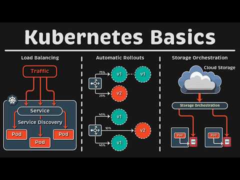
Three years ago, I started building an interactive learning platform to help people master Linux, networking, Docker, and Kubernetes in a visual and hands-on way.
Today, iximiuz Labs has:
- 60+ remote Linux playgrounds
- Dozens of interactive tutorials
- 100+ practical challenges
- A growing cohort of great authors
...and most importantly, 34.2 registered students with over 2,000 daily active users 🤯
Developing and operating a platform of such scale has become my full-time job, and honestly, the workload is outgrowing my capacity as a single-person SaaS founder. A proper team is becoming increasingly necessary.
If you're one of the students considering switching to the premium tier, now is the best time. On the premium tier, you will get:
- Full access to all current and future learning materials published by the iximiuz Labs team
- Twice bigger playground VMs with no daily usage time limit
- The ability to store the playground state and restore it later on
...and a whole bunch of smaller perks.
Why now? With the Black Friday deal, both the subscription and the lifetime plans are no longer a steal but a robbery. But there might be an even bigger reason - even undiscounted, the all-inclusive lifetime premium access is not a sustainable way to run an edu business, so all sales of this plan are going to stop by the end of the year. So, now _is_ the best time:
labs.iximiuz.com/premium
P.S. Of course, all revenue from the sales is reinvested in the platform's continued development 💪
English