
Meteorologist Nick Morganelli
3.5K posts
Meteorologist Nick Morganelli
@WeatherwithNick
Over 3 decades in broadcast meteorology. I get excited about educating others in storms, patterns, climate influences, optical phenomena, and so much more.
Springfield, MA Katılım Eylül 2012
154 Takip Edilen733 Takipçiler

T-Rex wants to know what's for dinner today?
same as yesterday & same as tomorrow

English
@robperillo Could be catastrophic for communities that get the core of prolonged freezing rain. Generators will sell out......
🙏🏼🙏🏼🙏🏼
English

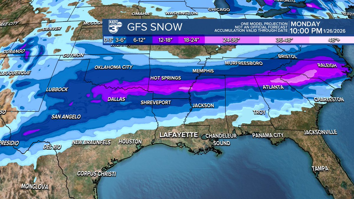
The Euro pointing to a crippling ice storm for the northern part of the state with the risk of some ice accumulations reaching into Northern Acadiana.
Meanwhile, the GFS is much more bullish on an ice event for Acadiana as it brings down sub-freezing temperatures sooner than later.
Either way, this will be a huge winter storm with more than a foot of snow from portions Eastern OK/NE Texas into Arkansas all the way to the East Coast, in some places maybe up to 2 feet may fall!
Plan on major road and air travel impacts across the I-20 corridor this weekend...and perhaps beyond as cold air stays in place through next Tuesday morning.
And if the GFS pans out, we'll have some major issues here locally...but the exact details will not be worked out until we get into the shorter, high resolution model ranges starting Thursday...stay tuned!
Our chances of snow locally in Acadiana look quite low, but we may catch some snow flurries as precipitation comes to an end Sunday. #lawx #winterweather


English

BREAKING NEWS!!! Trump is zojuist aangekomen in Groenland
Nederlands
7:35am Tue Jan 13 '26 Mount Mansfield Vermont
Out The Door Weather'n More Prequel
English

Chance for a snow shower Thursday, then the coldest air of the season so far by Friday morning. fox61.com/forecast #fox61
English
@iCyclone Prayers for your safety my friend!!🙏🏼🙏🏼🙏🏼
English

#Hurricane #MELISSA's track up to now. It's foolish to read personality into storms, but this track gives the feeling of a predatory serpent getting ready to attack. Winds are up to 150 mph. This is going to be a rough ride—no doubt. But #Jamaica will get through it. 👊

English
Hope to see you Saturday! Let's celebrate America and honor our veterans!
eventbrite.com/e/salute-to-se…
English
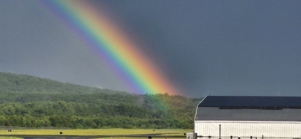
Westfield MA storm peaked 5:30 to 5:45. Rainbow by 6pm at BAF


English
The New England Drought of 2024 established last summer & fall is coming to an end. It always at least evens out within a season or two in the northeast.
If we have a dry early summer perhaps it makes a return? Time will tell. Outlook has drought shifting west next few months.

English
Just to get somethin' straight: I am not becoming "well-rounded." Snow fell on my house in January, and yeah, I drove an hour to see a tornado IMBY. So? I will remain arrogantly & obnoxiously focused on hurricanes. I will continue to look down on other kinds of weather. Thx.
English
@robperillo Welcome to my world! Hope everyone stays safe.
English
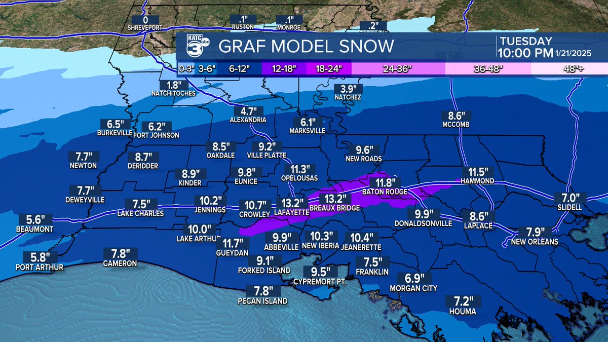
I keep waiting for a model run that may disappoint on the snow totals forecast for Acadiana and it hasn't happened yet. Still 4-8" possible with latest GFS, GRAF and earlier Euro all supporting such...eventually we'll be blending the GRAF/EURO and coming soon, the extended HRRR for our most accurate forecasts.
I'll have more later this afternoon....here's the current crawl I have running on KATC:
A Winter Storm WATCH is in effect for all of Acadiana from Monday evening through Tuesday evening...Wintry precipitation is expected to begin around midnight Monday night with accumulations beginning by daybreak Tuesday...
Locally moderate to heavy snow is expected Tuesday morning ending during the latter part of the afternoon. Accumulations of up to 4-8 inches are possible that will lead to hazardous travel conditions Tuesday and will likely continue into Wednesday or Thursday as snow compacts to ice on roadways...
Bitter cold follows with temperatures in the teens accompanied by single digit wind chills possible Tuesday night into Wednesday...Cold Weather Advisories will be in effect through Thursday morning...
Sub-freezing temperatures at night for the coming week could keep snow and ice on the ground and in the region perhaps until the weekend...
Temperatures however will moderate Friday into the weekend...Residents are urged to have a plan and provisions for a couple of days in place by Monday night...Stay with KATC, katc.com and social media for further updates... #lawx


English
Rare non-severe mammatus clouds over the Connecticut Rivwr, Springfield MA


English
@realDonaldTrump Incentivize deportation. Any person,family turning themselves in to the authorities in 2025 will be prioritized to re-enter legally beginning July 4th 2026..
English
@DHTheWeatherNut Actually, it's a very active pattern ahead with swings in temps increasing baroclinicity latitudinally and inland to shore. It would only take a decent vort max at the right time! Hoping...... Blessed xmas!
English

Eye Candy... pattern doesn't really support it before XMas, but fun to look at... entertainment for nuts like myself and snow-loving mets....

English
@TylerJankoski Some permafrost up there? That means more runoff, less absorption. Happy Christmas Season Tyler!
English

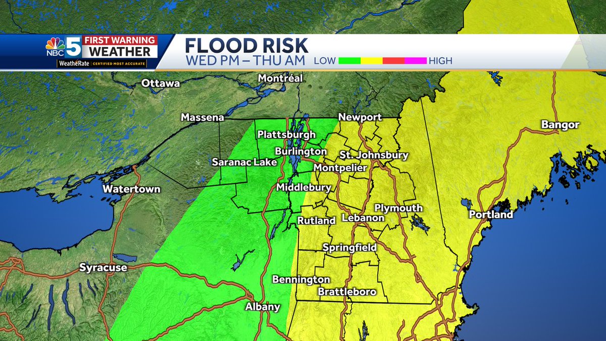
Not all rivers have gauges or forecast points. So, what happens if you live near a smaller waterway without an official forecast? Well, this map is helpful — river flooding is more likely in the yellow color. The ongoing drought is helping to mitigate some of this.
English
@ReedTimmerUSA Great shirt Reed! 🤣🥳
Joyful Christmas Season to you and yours. 🎅
English


This is a video compilation of our recent Salute to Service Celebration.
Please support our service members & consider a donation today, so together we can Break Barriers in Military Health Care.
Thank you so very much. medicnowfoundation.org
facebook.com/share/v/1W66eX…
English
Sundog forming over Springfield Massachusetts

Norsk