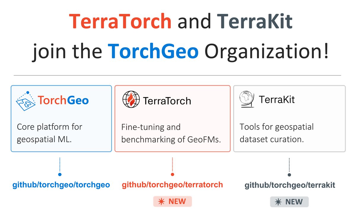
Caleb Robinson
179 posts

Caleb Robinson
@calebrob6
Research scientist on Microsoft's AI for Good team.
Katılım Ocak 2016
546 Takip Edilen718 Takipçiler
Caleb Robinson retweetledi

Working on transfer learning and foundation models in remote sensing? We invite you to submit abstracts to our session IN005 at #AGU25 (agu.confex.com/agu/agu25/prel……) organized by @sherwang (MIT),@hannah_kerner (Arizona State), Siddharth Sachdeva, and me (Stanford).

English
Caleb Robinson retweetledi

Researchers at @Microsoft’s AI for Good Lab, in collaboration with @WildNatureInst, have developed GIRAFFE, an open-source AI-driven system to automate the identification of individual giraffes.
Learn more about our new AI-powered tool. msft.it/6017SQgyW
GIF
English
Caleb Robinson retweetledi

An expanded version of our TorchGeo paper has been accepted to ACM TSAS @TheOfficialACM
In addition to even more benchmarks on remote sensing datasets, we provide a thorough survey of open-source libraries for deep learning for geospatial data
@calebrob6 @BDataScientist


English

@Ritwik_G Here's a small experiment using MOSAIKS features and KNN-3 (notebook gist.github.com/calebrob6/7495…). Looks like there is some interesting space for showing gains vs. simple methods with few training samples. Would love to see 90+ acc with a handful of examples!

English

@calebrob6 There have been papers that have evaluated on EuroSAT in few-shot settings, but there’s no standardized dataset for it. Let’s talk about it!
English
Caleb Robinson retweetledi

NOAA has posted satellite imagery from the areas affected by the Eaton, Hurst, and Palisades wildfires. The imagery is available through Maxar's Open Data program to support the emergency response community and the public: #9.98/34.1904/-118.4094" target="_blank" rel="nofollow noopener">storms.ngs.noaa.gov/storms/2025_er…
Disaster-specific @FEMA resources are available here: fema.gov/disaster/4856

English

@mouthofmorrison @dmarvs @earth_chris And 6,3,1 gets you pretty close :) -- we reproduced here aka.ms/los_angeles_ea…

English

@mouthofmorrison @dmarvs @earth_chris The raw data is in their open data program if you're curious! -- #events/WildFires-LosAngeles-Jan-2025/or2a/016511482010_01/016511482010_01_P002_SWR/" target="_blank" rel="nofollow noopener">qoomon.github.io/aws-s3-bucket-…
English

@yacineMTB @growing_daniel Yes, you can see before/after satellite imagery here aka.ms/los_angeles_pa…. There are ~2k destroyed buildings visible in this scene
English
Caleb Robinson retweetledi

The Climate Change AI workshop at NeurIPS tomorrow will be livestreamed for free, even if you weren't able to register for NeurIPS (which was oversubscribed this year)!
Climate Change AI@ClimateChangeAI
Another highlight of our #NeurIPS2024 workshop on Sunday will be a panel discussion on small vs big models in ML for climate impact, featuring Chris Bretherton, Anamika Dubey & @BDilkina. Stream the whole workshop live & for free via our website: climatechange.ai/events/neurips…
English
Caleb Robinson retweetledi

🚨Our new review paper "Better, not just more: Data-centric ML for Earth Observation" 🌐🤖🛰️🔍 has finally been published in GRSM. Shifting the focus from models to data offers new possibilities to improve accuracy, generalization, and real-world impact: ieeexplore.ieee.org/document/10740…
Joint work with @MarcCoru, Caroline Gevaert, @MKampffmeyer, @jeferssonalex, @MariaVakalopou1, @RonnyHaensch, Stine Hansen, @Keiller, Jonathan Prexl, @devistuia
Arxiv version: arxiv.org/abs/2312.05327

English

@MaxLenormand If you don't need very recent -- there is 60cm NAIP imagery from 2022 on the Planetary Computer (RGBNIR)
English
Caleb Robinson retweetledi

'How geospatial AI can help us understand global scale challenges such as climate change or food insecurity. '- @tammyglazer
#Geospatial #GeospatialAI
English

It was so fun working on this with @hannah_kerner, @jacobsn, @opencholmes, @GhoshPrivate, @Adeal_GIS, @matthmohr, @rdodhia, @BDataScientist, Snehal Chaudhari, Eddie Choi, and Jennifer Marcus!
English

a baseline for training and testing global models.
Paper: arxiv.org/abs/2409.16252
Code: github.com/fieldsofthewor…
Website: beta.source.coop/repositories/k…
English

1/ We released Fields of the World (FTW)-- a new satellite imagery + field boundary dataset with samples from 24 countries (now downloadable via torchgeo)! One cool part of this work is that we find that models trained on FTW have decent zero-shot performance in new locations:
Hannah Kerner@hannah_kerner
I'm so excited to finally introduce Fields of The World (FTW!) - the largest & most diverse ML dataset for field instance segmentation in satellite images. FTW has >70k samples from 24 countries (4 continents), with semantic & instance labels + Sentinel-2 RGB-NIR from 2 dates. 🧵
English

1/🚀TorchGeo 0.6.0 is here!
TorchGeo is a python library for deep learning with geospatial datasets. This large update contains new datasets, foundation models, and more -- over 11 months of hard work from many contributors! See more details: github.com/microsoft/torc…
English


