Dave WX ⛈️

251 posts

Dave WX ⛈️

Dave WX ⛈️

@davewxIE

All things weather with a focus on severe weather! Focus mainly Europe (Ireland), but also interested in North America! All views are my own ⛈️

Ireland Katılım Ocak 2024
28 Takip Edilen6 Takipçiler
Dave WX ⛈️
Dave WX ⛈️@davewxIE·
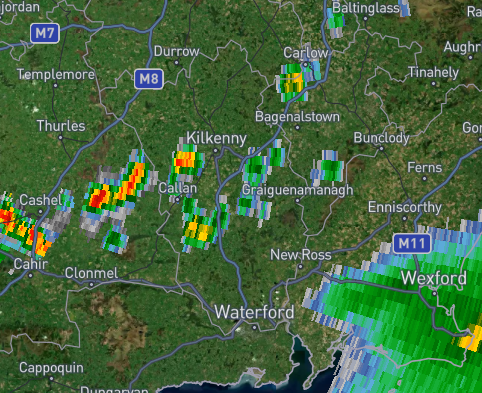
Yellow Thunderstorm warning for Kilkenny and Tipperary. Few storms have popped up around Southern KK. Hail and Downpours will be associated with these storms. There is a bigger storm complex just over Wexford that will track in this direction to the West.
Dave WX ⛈️ tweet media
English
0
0
0
24
Dave WX ⛈️ retweetledi
Dave WX ⛈️
Dave WX ⛈️@davewxIE·
Lots of storms developing over SW Ireland. There is also a trail of storms that will track over the South East in the next 2 hours.
Dave WX ⛈️ tweet media
English
0
0
0
10
Dave WX ⛈️
Dave WX ⛈️@davewxIE·
The initiation of storms in Cork is extremely impressive and rather electrically active!
Dave WX ⛈️ tweet media
English
0
0
0
60
Dave WX ⛈️
Dave WX ⛈️@davewxIE·
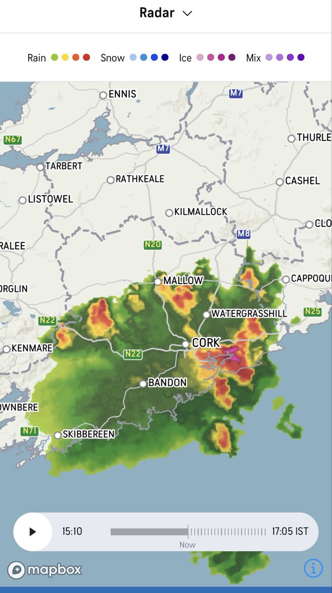
I would say that the storm to watch is the one that is just rolling into Cork City now, looks the more impressive out the bunch. Please be mindful of Hail and Spot Flooding.
Dave WX ⛈️ tweet media
English
0
0
0
69
Dave WX ⛈️ retweetledi
LaoisWeather
LaoisWeather@LaoisWeather·
Impressive returns!
LaoisWeather tweet media
English
1
2
4
286
Dave WX ⛈️
Dave WX ⛈️@davewxIE·
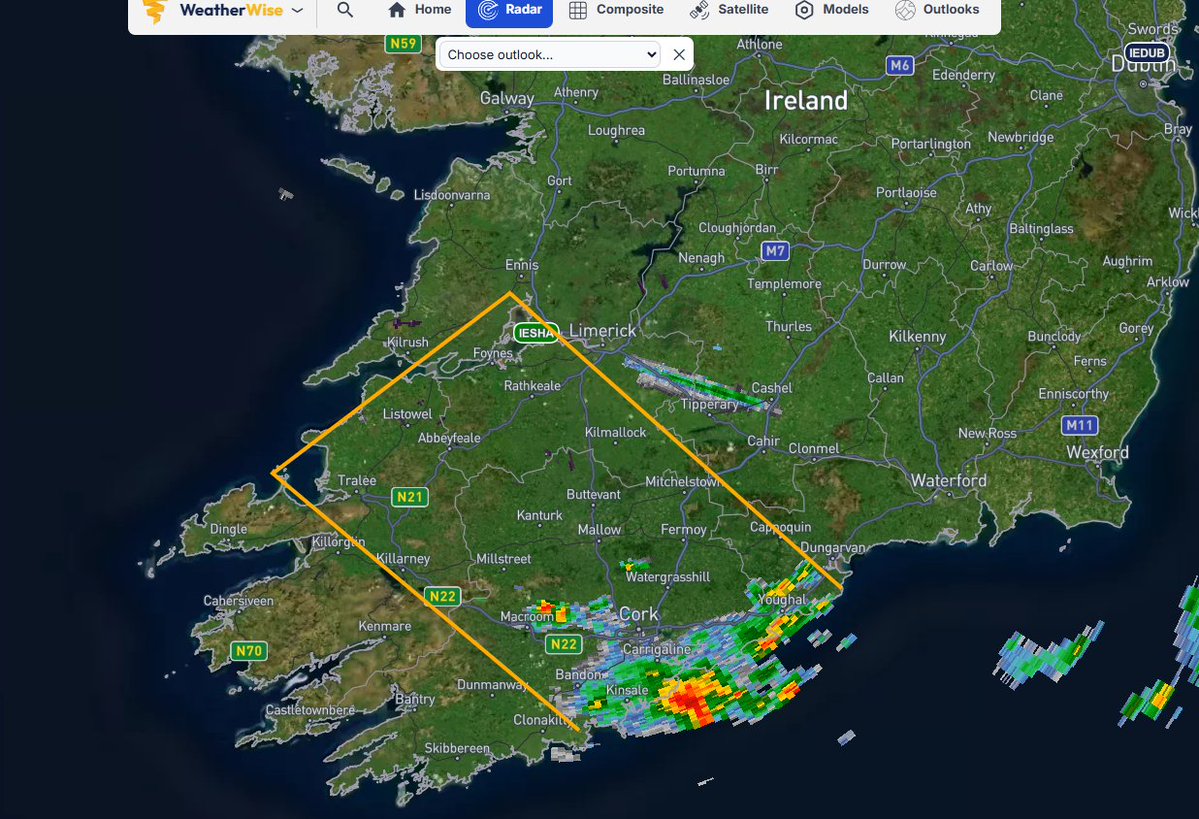
Orange Thunderstorm Warning Issued for County Cork. Expect large hail, severe wind gusts and localized flooding. More storms expected to trail behind in the area below.
Dave WX ⛈️ tweet media
English
0
1
1
155
Dave WX ⛈️ retweetledi
Met Éireann
Met Éireann@MetEireann·
❗️Update - Status Orange Thunderstorm Warning issued for Cork. ⏲️Valid: 14:00 until 16:00 today 27/05. ➡️Potential for lightning & hail damage. ➡️Slippy roads and impaired visibilty, where showers hit. 🔗met.ie/warnings-today…
English
2
10
17
3.8K
Dave WX ⛈️ retweetledi
Met Éireann
Met Éireann@MetEireann·
⚠️Status Yellow Thunderstorm Warning Issued for: 📍Cork, Kerry, Limerick, Waterford & Wexford ⏲️Valid 14:00 until 19:00 today 27/05 ➡️Potential for lightning & hail damage. ➡️Slippy roads and impaired visibility, where showers hit. 🔗met.ie/warnings-today…
English
1
14
19
6.8K
Dave WX ⛈️
Dave WX ⛈️@davewxIE·
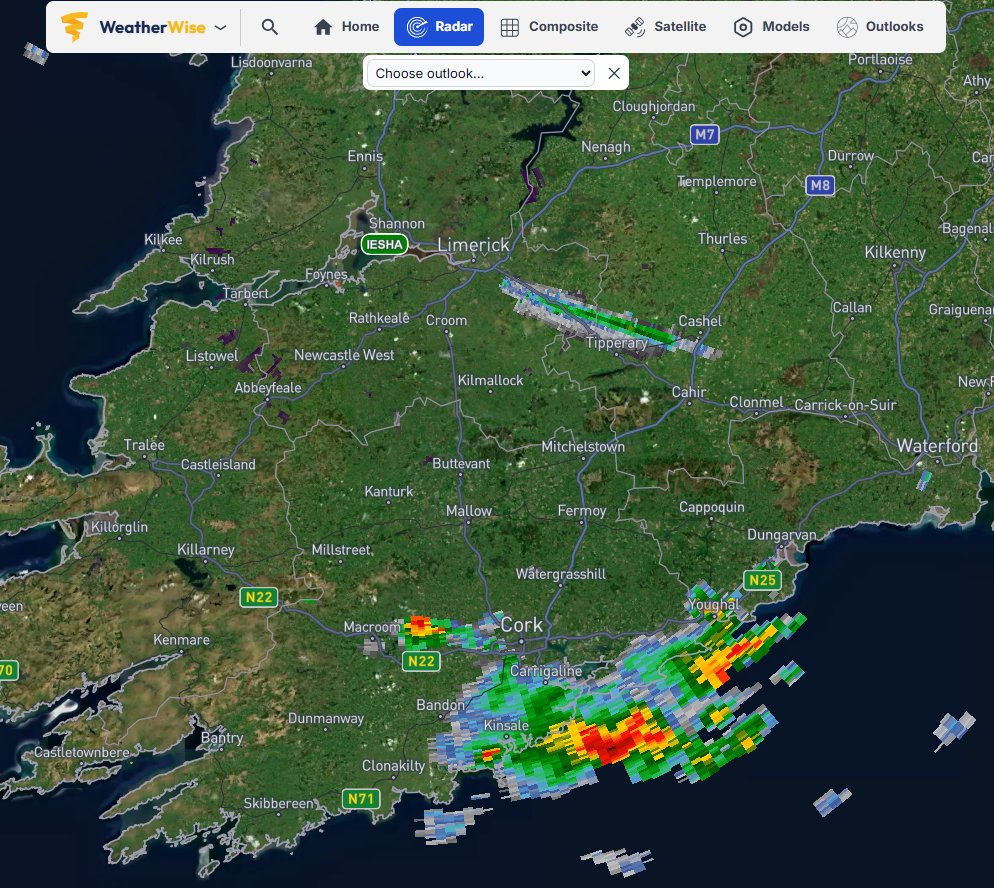
Initiation of Thunderstorms already an hour or so earlier in Ireland. One discrete storm has formed out infront of the convection east of Macroom Co. Cork. A hail/wind risk will be associated with these storms.
Dave WX ⛈️ tweet media
English
0
0
0
95
Dave WX ⛈️
Dave WX ⛈️@davewxIE·
@bud9wx @BostonWeatherUK Im not sure if the South West of Ireland warrants a moderate, cape is high but sheer is not great, mostly hail/wind risk.
English
1
0
0
38
Boston Weather
Boston Weather@BostonWeatherUK·
Am I weird for thinking today is probably going to bust. I see maybe weak stuff on models but not enough for HIGH, maybe just SLGHT evem.
Mesocast@MesocastUK

WED 27 MAY - THU 28 MAY 06Z - 2026: mesocast.uk/forecast/?date… UPDATE 27 MAY 2026 at 11:00am to expand slight risk polygon across Ireland and introduce a conditional lower confidence moderate for large parts of SW England, Wales and parts of the Midlands and South for later today and especially overnight tonight into the early hours of Thursday AM. Where models are firming up on plume destabilisation an active moderate is in place where strong/locally severe thunderstorms are possible, frequent to very frequent/prolific lightning (especially a cross the W Country into Soutern/Central Wales. A few active thunderstorms quite likely to break out across Southern and South West Wales through the rest of today could be locally surface based and an isolated LT supercell is possible. Main threats include large hail in stronger cells 2-3cm, locally damaging wind gusts to 55mph, torrential downpours and localised flash flooding and very frequent lightning. Thunderstorms will be predominiately elevated later this evening and overnight with storm coverage beginning to increase across Dorset/W Country/SW England migrating into Wales and with time expanding into the Midlands and Central Southern England through the early hours of Thursday AM. Close to issuing a conditional moderate for Wed., however confidence in consistency remains low. A few strong or even severe thunderstorms are possible again on Wednesday, perhaps less intense in coverage. An advancing short-wave should engage with a high theta-e plume advecting N from France through Wed. Timings of engagement are uncertain and therefore whether maximum convergence occurs during peak heating or later which dictates storm mode and coverage, however a few strong thunderstorms are likely. Main threats will be slow moving torrential downpours with the attendant risk of flash flooding, 1-2cm hail, possibly larger, gusty locally damaging winds upto 55mph, frequent lightning and the possibility of an isolated tornado. The situation will be monitored tomorrow morning with the possibility of an upgrade to a conditional moderate for favourable areas or an active moderate if confidence increases sufficiently.

English
3
0
10
1.9K
Dave WX ⛈️ retweetledi
Mesocast
Mesocast@MesocastUK·
WED 27 MAY - THU 28 MAY 06Z - 2026: mesocast.uk/forecast/?date… UPDATE 27 MAY 2026 at 11:00am to expand slight risk polygon across Ireland and introduce a conditional lower confidence moderate for large parts of SW England, Wales and parts of the Midlands and South for later today and especially overnight tonight into the early hours of Thursday AM. Where models are firming up on plume destabilisation an active moderate is in place where strong/locally severe thunderstorms are possible, frequent to very frequent/prolific lightning (especially a cross the W Country into Soutern/Central Wales. A few active thunderstorms quite likely to break out across Southern and South West Wales through the rest of today could be locally surface based and an isolated LT supercell is possible. Main threats include large hail in stronger cells 2-3cm, locally damaging wind gusts to 55mph, torrential downpours and localised flash flooding and very frequent lightning. Thunderstorms will be predominiately elevated later this evening and overnight with storm coverage beginning to increase across Dorset/W Country/SW England migrating into Wales and with time expanding into the Midlands and Central Southern England through the early hours of Thursday AM. Close to issuing a conditional moderate for Wed., however confidence in consistency remains low. A few strong or even severe thunderstorms are possible again on Wednesday, perhaps less intense in coverage. An advancing short-wave should engage with a high theta-e plume advecting N from France through Wed. Timings of engagement are uncertain and therefore whether maximum convergence occurs during peak heating or later which dictates storm mode and coverage, however a few strong thunderstorms are likely. Main threats will be slow moving torrential downpours with the attendant risk of flash flooding, 1-2cm hail, possibly larger, gusty locally damaging winds upto 55mph, frequent lightning and the possibility of an isolated tornado. The situation will be monitored tomorrow morning with the possibility of an upgrade to a conditional moderate for favourable areas or an active moderate if confidence increases sufficiently.
Mesocast tweet media
English
1
7
30
4K
Dave WX ⛈️
Dave WX ⛈️@davewxIE·
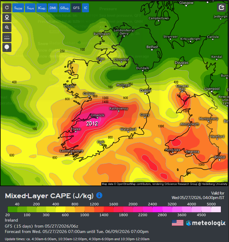
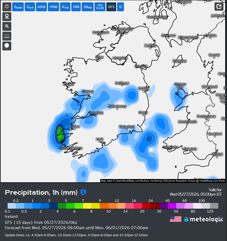
Wednesday 27/05/26 Not as warm as yesterday but still decently warm for Ireland up to around 26 degrees. There is a risk today of thunderstorms developing in the southwest in the evening hours. CAPE is still very high at 2000 J/kg, low sheer/cap means these will bring hail/rain.
Dave WX ⛈️ tweet mediaDave WX ⛈️ tweet media
English
0
0
0
15
Dave WX ⛈️ retweetledi
Max Velocity
Max Velocity@MaxVelocityWX·
An OMEGA BLOCK weather pattern will be developing late this week! This happens when two large low-pressure systems sandwich a high-pressure system. This should lead to decreased chances of severe weather outbreaks for the foreseeable future.
Max Velocity tweet media
English
53
81
1.1K
71.1K
Dave WX ⛈️ retweetledi
RTÉ News
RTÉ News@rtenews·
Temperatures are forecast to hit up to 30C today in some areas, according to Met Éireann, which could potentially make it the hottest day in May on record rte.ie/news/ireland/2…
English
60
29
161
33.5K
Dave WX ⛈️ retweetledi
Mesocast
Mesocast@MesocastUK·
Severe thunderstorm warning for areas North East and East of Nottingham and the Newark on Trent area. Very intense thunderstorm underway with flash flooding and likely large hail 2-3cm and locally damaging wind gusts to 55mph. Brief spins ups are possible too.
Mesocast tweet media
English
2
5
30
1.7K
Bud
Bud@bud9wx·
Outlook update for tomorrow. Continues to look like a highlight event for the year if it comes together. Holding off on moderate for now.
Bud tweet media
English
1
1
10
1.1K
Dave WX ⛈️
Dave WX ⛈️@davewxIE·
@bud9wx In terms of Ireland, inclined to agree we will see some scattered Thunderstorms possibly in the evening! Will be interesting!
English
0
0
1
18
Dave WX ⛈️ retweetledi
Bud
Bud@bud9wx·
What did I just see here?
English
16
9
76
13.3K