
FireMap.live 🔥🌎
1.6K posts
FireMap.live 🔥🌎
@disaster_db
Real-time wildfire data at your fingertips 🌍 | Visualize global wildfire activity instantly 🔥
Global Katılım Mayıs 2024
500 Takip Edilen4.9K Takipçiler

🇺🇸 Seattle tourist throws a rock at a monk seal in Maui, gets beaten up by a local for it, and now faces $50,000 in fines and jail time.
The local got a letter of recognition from a state senator.
Local justice. State-approved.
English
FireMap.live 🔥🌎 retweetledi
Earth goes hard: Earth is an interesting place to say the least. It’s mostly water, but we call our planet by the name of which we live on, sleep on, fight on, love on, build on, and grow on…. Earth.
As of right now, it’s the only home we have. It would be sweet if we had a second planet to run away to, cherish, expand, flourish, and protect, but we don’t.
We have Earth. All of us.
Earth isn’t this calm island in the vastness of space. Earth is volatile, regions where humans live at -90°F, places we call Death Valley that reach 134°F, ice covered peaks that reach to the stars, and unforgiving oceans deeper than most can fathom.
We have floods, hurricanes, tornadoes, earthquakes, and wildfires. Wildland firefighters go out everyday to protect the natural beauty of Earth’s forests, rangelands, and its awe inspiring wilderness.
Stewards of this land that in all its natural turmoil is undeniably beautiful. Raw beauty, raw power, and grand life giving landscapes that disappear over the horizon with the setting Sun.
But it’s the only home we have… and that should never be forgotten. And despite the conflict and struggles that come with living on such a unique and magnificent home, it’s our duty to take care of it for those that come after us, both human and animal alike.
Happy Earth Day

English
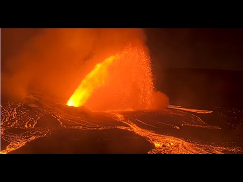

Kilauea Message 2026-04-14 19:08:53 HST. The V3cam live stream has shown impressive flames at the Halemaʻumaʻu south vent this evening (especially around 7:00 p.m. HST), the result of igniting volcanic gases as they escape the vent.
English
FireMap.live 🔥🌎 retweetledi
Kīlauea Update — Episode 43
Lava fountaining at Halemaʻumaʻu began at 9:17 a.m. HST and continues. Fallout particles up to football‑sized has been reported at Hawai‘i Volcanoes National Park overlooks.
Alert Level raised: WATCH → WARNING.
Plume height: 25,000 ft.
Winds blowing from the south may carry volcanic gas/ash northward.
Follow official guidance from County of Hawaii Civil Defense Agency and Hawai‘i Volcanoes National Park.
English

We are proud to honor the 2025 GSA President’s Medalist, OpenTopography Facility, composed of J Ramón Arrowsmith, Christopher Crosby, Viswanath Nandigam, Chelsea Phipps Scott.
GSA's President's Medal is awarded to individuals, groups, or entities whose impact has profoundly enhanced the geoscience profession through (a) supporting and contributing to the Society; (b) advancing geosciences, enhancing professional growth, and/or promoting geosciences in service of humankind; or (c) significantly enlarging the range of scientific achievement for the growth of our profession.
Launched in 2008, OpenTopography has transformed the geosciences by providing open, user-friendly access to high-resolution topographic data for researchers, educators, practitioners, and the public. Its cyberinfrastructure has advanced research across geomorphology, tectonics, hydrology, environmental science, and beyond, while serving as a leading model for open and collaborative science.
Through the leadership of Ramon Arrowsmith, Chelsea Scott, Christopher Crosby, and Viswanath Nandigam, OpenTopography has democratized access to critical Earth surface data and reshaped how topographic information is used across disciplines.
Learn more and submit your nomination for the 2026 GSA President’s Medal: geosociety.co/PresidentsMedal


English
FireMap.live 🔥🌎 retweetledi

Today marks one year since the LA wildfires, a moment that resonated far beyond California. From the first alert to the long journey to rebuild, we'll be there to continue to support our neighbors. #LAStrong 💛
English
FireMap.live 🔥🌎 retweetledi

Kilauea eruption continues 🌋🔥 People watched as lava shot over 1,000 feet high from Hawaii’s Kilauea volcano during its latest eruptive episode over the weekend.
English
@joelgombiner @BadWeatherKyle They even have volcanos and “lava bombs” cannon balls. Pretty neat but the overcast from Oakanagan in winter is hard for the sunshine lovers like me.
English

@BadWeatherKyle + world class glacial geomorphology. what's not to like?
English
I'm a born-and-raised Albertan, and I love this land with all my heart...but man, the Okanagan sure seems nice these days

English

Powerful Category 4 Hurricane #Melissa continues to strengthen south of Jamaica, while becoming nearly stationary. This storm still has some room to strengthen, unfortunately, as the relatively large eye could constrict even further in this prime environment! By tomorrow night into Monday, a north and northeast turn toward Jamaica is forecast, with a mega disaster likely there regardless of direct landfall. Stay away from the shoreline, creeks and rivers and find a concrete structure if you can!
English

🌋 Time-lapse of a minor phreatomagmatic eruption at the Main Crater of Taal Volcano, recorded at 5:30pm (Philippine time) today.
The event produced eruption plumes rising approximately 1,200 meters above the crater.
Alert Level 1 remains in effect over Taal Volcano.
Credit: PHIVOLCS
English
@BadWeatherKyle Couldn’t agree more! It’s all about using what makes us unique to create positive change.
English
In case you didn't know it:
You matter.
There is no one else on Earth exactly like you.
The skills you possess can make the world a vastly better place. 🤝

English
FireMap.live 🔥🌎 retweetledi

FireMap.live 🔥🌎 retweetledi
Kilauea Message 2025-10-17 22:11:14 HST. Record high fountains for this eruption, nearly 1500 feet high.
volcanoes.usgs.gov/hans-public/no…
English

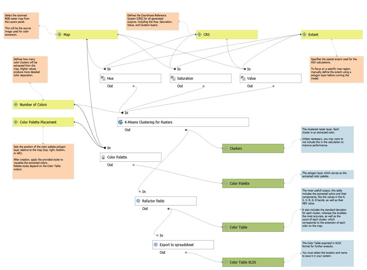
I recently published the #QGIS Color Extraction Model I’ve been working on: github.com/StaridasGeogra….
I’d be grateful if you tried it out and shared your feedback so I can keep improving it!
English

Today’s my birthday, and I’m celebrating by doubling down on what changed my career: teaching people to make powerful maps in R.
My book Mapping the World with R isn’t brand-new anymore, but that’s the point. It’s battle-tested, shaped by years of coding, teaching, and answering your questions. If my tutorials helped you level up, buying (or gifting) this book is the best birthday present you could give me.
What you’ll get:
• 11 end-to-end projects mirroring real spatial challenges
• 40+ hands-on examples with clean, reproducible code
• Authentic datasets pulled directly through R packages
• Practical workflows in sf, terra, rayshader, and the tidyverse
• Design guidance for clear, professional maps
Who it’s for:
• Newcomers wanting a guided path from zero to map-maker
• Students and analysts building standout portfolios
• Designers and storytellers adding data-driven maps
If you’ve been meaning to start or get consistent with your geospatial workflow, this is your blueprint.
Grab your copy here 👉 payhip.com/b/MH9Ot
Or here 👉 milosmakesmaps.com/products/mappi…
If you pick it up today, tell me what place you’ll map first in the comments. I’ll be cheering you on. And if this post helped, share it with one person who loves maps—that share goes further than you think.
Here’s to another year of learning in public and to your next map being your best one yet!

English

Reason why all Geospatial peeps love Postgres….because of this Out of the box support for Spatial data….using Postgis! #gischat
Python Programming@PythonPr
Types of Databases!!!
English
🚨🇵🇭 PATIENTS AND STAFF EVACUATE HOSPITAL AFTER 7.6 QUAKE IN DAVAO PHILIPPINES
Patients and medical staff were seen evacuating the Davao Regional Medical Center in Tagum City after a powerful magnitude 7.6 earthquake struck the southern Philippines.
Videos show people rushing outside as tremors shook buildings across Davao region.
Source: @AZ_Intel
Mario Nawfal@MarioNawfal
🚨🇵🇭BREAKING: TSUNAMI WARNING ISSUED FOR SOUTHERN PHILIPPINES AFTER 7.6 QUAKE A tsunami warning has been issued for parts of the southern Philippines following a preliminary magnitude 7.6 earthquake offshore. Authorities say life-threatening wave heights are expected. Source: @AZ_Intel
English


@MtnMapper Nice use of labels over the continental divide. 🫡
English

Preliminary type on my S. America physical map. There are 856 river and 391 peak labels so far. Coast labels are next.

English