Sabitlenmiş Tweet
esdul
19.9K posts


@NoBardamu @shakisiera pero sí, obvio que se come bien en la fabrica de pantalones !
Español

@shakisiera Es buen índice, si el lugar es una poronga y la gente sigue yendo, probablemente la comida y el servicio son fabulosos. La inversa es más frecuente.
Español

Que mucho de la narrativa cool sea ir a lugarcitos de paredes mal revocadas y con manchas de humedad es un recession indicator? Porque la propuesta por ej. del piano y bar invita pero si te escindís de los lentes de la moda, bajo qué argumento atrae un lugar así?!



Español
esdul retweetledi


esdul retweetledi


esdul retweetledi

esdul retweetledi





esdul retweetledi

Breaking News!
Code: Godzilla!
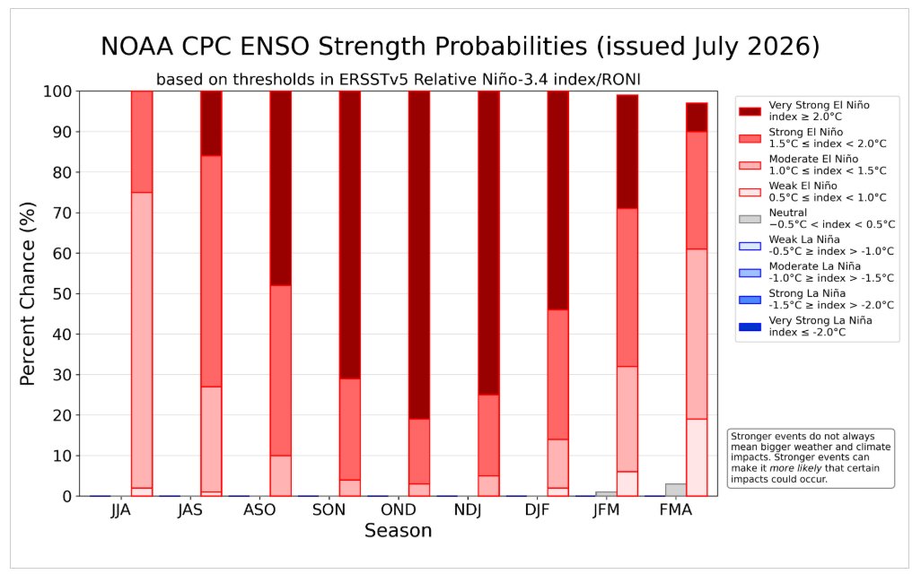
The latest monthly update by NOAA to the ENSO strength probabilities was just issued this morning. The forecast now shows over an 80% chance that Godzilla will rise from the ocean over the three-month period OND, up from 63% last month.
cpc.ncep.noaa.gov/products/analy…
English
se viene un Super El Niño
Colin McCarthy@US_Stormwatch
The 2026-27 El Niño is simply astonishing. Tropical Pacific waters are running nearly 7 weeks ahead of where they’ve ever been at this point in an El Niño cycle in modern history. Models now put the peak strength at 3.6°C on the Relative Oceanic Niño Index (RONI), the new standard for measuring El Niño that adjusts for background ocean warming from climate change. That would beat the previous record (Dec. 1877, the strongest El Niño ever observed) by 0.7°C. In the context of climate, that’s completely blowing the previous record out of the water. For context, an El Niño is informally considered a Super El Niño when, for 3 months, the Niño 3.4 index is 2.0°C or above. Frankly, expect extreme climate and weather impacts over the next 12-18 months. Forecasts have also been consistently, aggressively wet for California and the southern US. Many of California’s largest floods have hit during El Niño years, and in very strong events, El Niño typically becomes the single best predictor of a very wet winter in California. It also elevates the odds of a megaflood in the state. @Weather_West’s research found 7 of 8 modeled ARkStorms occurred during moderate-to-strong El Niño years. The bigger picture: 2027 could be the first year Earth briefly touches 2°C above preindustrial levels. With each successive model update, the forecasted strength of El Niño is increasing, with ensembles now putting a 94% chance on a Super El Niño this winter. Virtually certain.
Español