Joey Peddle retweetledi
Joey Peddle
1.8K posts

Joey Peddle
@joeyp239
tropical cyclones & synoptics | sww for environment canada | former president @vividweather '24 - '26 python developer #GoBolts | #nlwx
Newfoundland, Canada Katılım Kasım 2022
469 Takip Edilen416 Takipçiler


Joey Peddle retweetledi

Very interesting "Standing Gravity Wave" (SGW) feature on the north side of Sinlaku's CDO with a distinct boundary in brightness temperatures. Their formation process is currently not understood, but (somewhat anecdotally) intense TCs often exhibit them in their structure.
GIF

English
Joey Peddle retweetledi

Tom Anderson from Google: the Deepmind Model is the equivalent to a decade jump in progress in reducing track/intensity error.
In other words, this AI model — which is outperforming every global numerical model — is an absolute forecast game changer.


English

1/5 🧵
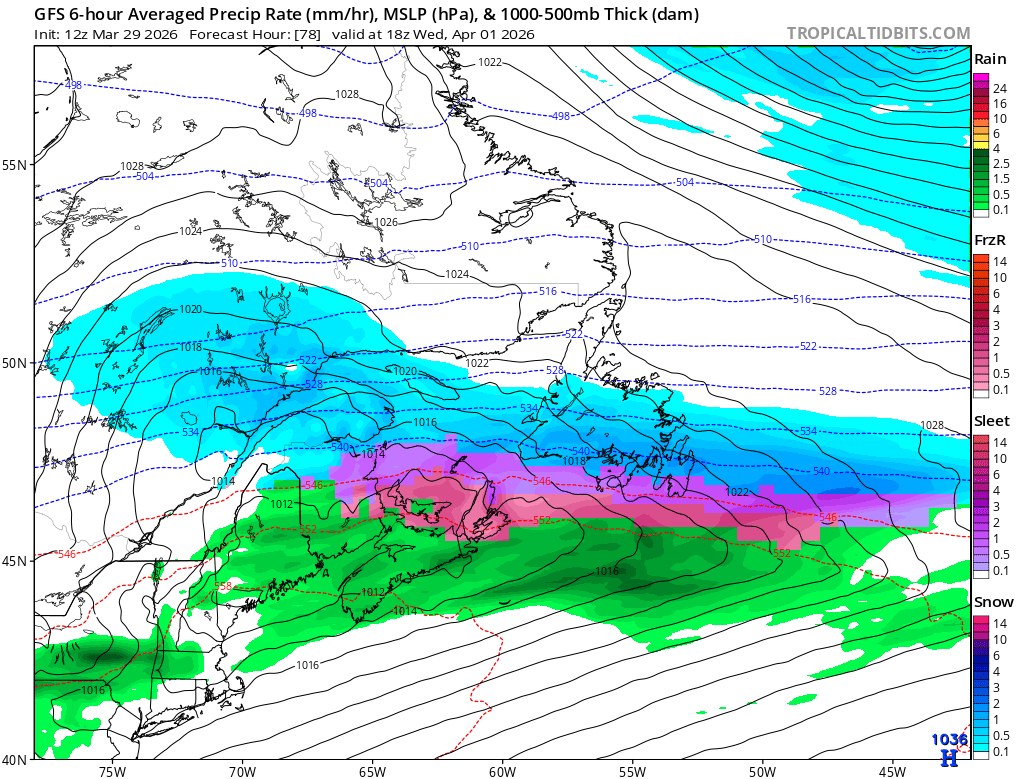
Breaking my winter hiatus for this one. Seeing a lot of posts about a potential winter system on April 1 to 2, but most of those “forecasts” are just singular operational runs. Guidance is still not resolved on the large scale pattern or the storm track. #nlwx
English
5/5
That is why I do not buy the colder operational runs at this stage. Until the Labrador trough is actually resolved, snowfall maps and impact graphics being shared around are conditional output from an unresolved pattern, not something I would treat as a forecast. #nlwx
English
4/5
That is a much warmer outcome. Stronger warm advection and a warmer boundary layer simply reduce the potential for widespread winter precipitation. The colder solution needs a deeper trough digging south over Labrador, and that looks under supported right now. #nlwx
English
Joey Peddle retweetledi

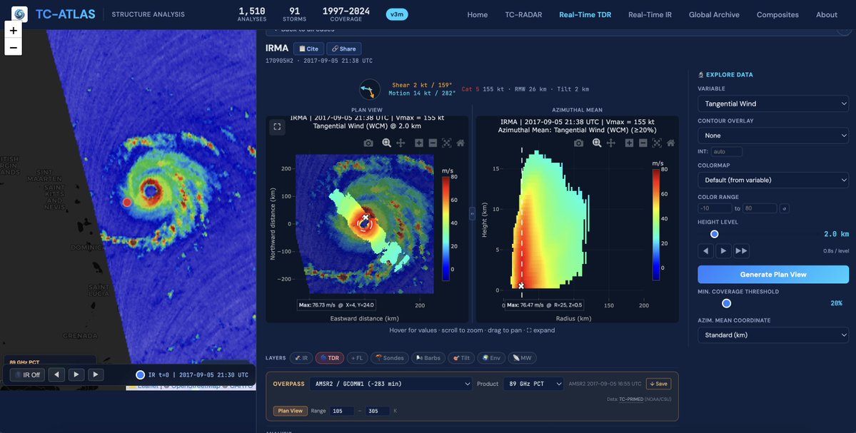
Interested in hurricanes? I want to introduce TC-ATLAS: the Tropical Cyclone Analysis Tool for Live and Archived Structure. Explore live or past storms without writing a line of code or downloading a data file, building on the capabilities of TC-RADAR: michaelfischerwx.github.io/TC-ATLAS/index…


English
Joey Peddle retweetledi

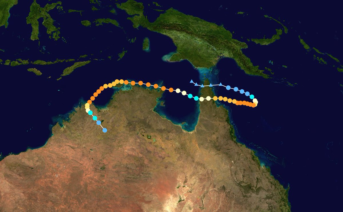
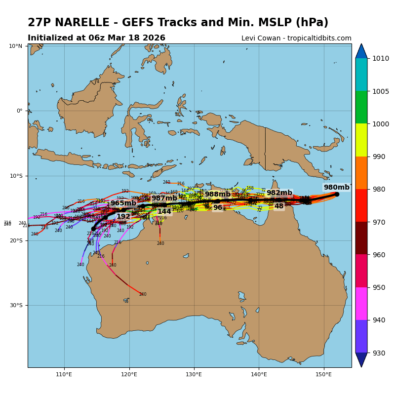
Definitely seeing some clear track parallels to Cyclone Ingrid (2005), although Narelle should take a more southward and westward path into the open Indian Ocean rather than a landfall here.
Andy Hazelton@AndyHazelton
I wonder what the record is for number of landfalls in the same country by one TC? Looks like #Narelle could make a run at it depending on the exact track. I'll also be interested to see how much it intensifies in the Gulf of Carpenteria and again after crossing back into the Indian Ocean eventually.
English
Joey Peddle retweetledi

A sensationalist Media-rologist further decreasing society’s trust in the NWS whilst profiting off of taxpayer funded dollars leaves a sour taste in my mouth. There are many other better ways to support proper awareness for inclement weather - this is not it.
Ryan Hall, Y’all@ryanhallyall
Introducing Y'all Call: the service that calls your phone when severe weather targets your specific address. Stop guessing with generic apps and get precise, life-saving alerts when it matters most. Don't be scared, be prepared. Peace of mind is just $20/yr at yallcall.app
English
Joey Peddle retweetledi
Though still murky thanks to warm water off Japan the PDO is looking more positive than most times this decade. You can see the +PMM connect with warmth in the WPAC as well. This has been slowly headed east. El Nino is on the way and it should have more PDO support than 2023
English
Joey Peddle retweetledi


Joey Peddle retweetledi

Starting to work with WeatherNext 2 data from Google - the comparison to AIFS-ENS will be interesting.
For example, the latest WxNext 2 picks up an Aleutian ridge returning by day 14, consistent with subseasonal models for the second half of February


English
@Veeringwindswx i’m about to focus an absurd amount of frontogenetic lift into a very narrow corridor
English


8/
Summary: The most likely outcome is a broad convective gyre with embedded lows (EURO portrays this nicely), but the probability of at least one organized surface circulation is meaningfully elevated. A short-lived tropical cyclone is still unlikely, but cannot be ruled out #wx

English
7/
SSTs are only marginal, but strong upward motion and moisture anomalies can offset that limitation. Only a very small amount of EPac cyclones have formed under similar intraseasonal forcing w/ cool climatology.
English
🧵
The eastern Pacific is entering a rare intraseasonal window. A strong WWB is propagating east with a coupled Kelvin wave, weakening the trades and generating cyclonic shear vorticity north of the equator, the same setup that precedes most EPac genesis events. #wxtwitter
1/8

Eric Webb@webberweather
Good lord. This Westerly Wind Burst in the Tropical West Pacific late month is so strong on the Euro weeklies it's wrapping the scale 😂 If there was any doubt we weren't getting an El Niño later this year, this just about does it.
English