First demo of our new aerial Visual-Inertial Positioning System (VIO+VPS): 40m positioning accuracy (CEP) in a 50 kilometer flight using a camera, consumer-grade IMU and a barometer! No GPS
Spectacular AI flight testing in winter conditions: -13 °C (8.6 °F), low altitude, full snow cover. No significant issues. GPS-free autonomous closed-loop navigation powered by VIO.
I am really impressed by how easy Spectacular AI makes visual-inertial odometry with an OAK camera.
Just "pip install spectacularAI" and run a Python script. Running VIO/SLAM used to be much harder in my opinion.
Spectacular AI visual-inertial navigation module prototype. Plugs directly into Pixhawk and runs VIO+VPS in real-time. R-Pi CM4 and low-cost commodity components only. 110 grams, 64 x 64 x 70 mm. Closed-loop demo.
SW and HW guide available in selected countries with a commercial license: #contact" target="_blank" rel="nofollow noopener">spectacularai.com/#contact
Low-cost autonomous GPS-free navigation (closed-loop): Pixhawk mission flight mode with Spectacular AI
VIO as “fake GPS”, running real-time on #raspberrypi CM 4. Extra sensor & compute weight < 100g
@itsolelehmann How do you mean "ignores"? GDPR bans Google Analytics -like ad-surveillance independent of the tracking technology and it's not specific to cookies. No EU country just has the guts to enforce it properly (like confiscating Google's/Meta's ad revenue) and the result is this mess
Europe created a monster:
• Forces annoying popups on EVERY website
• Costs businesses €10 BILLION+ in compliance
• Provides ZERO actual privacy protection
The annoying truth about how one dumb "feel good law" is slowing European innovation 🍪:
@ccallac7@ThePunkHucker Yes. The implementation supports that. It does not have to be a complete tree. The essence of the method is that only the non-empty max. depth leaf nodes are stored in the array, but the contents of any "virtual" node at any level can be queried using binary search.
Interesting, i was trying to think of an implicit representation of an octree so that you could store it in an array like a complete binary tree (no pointers would make it significantly more compact). My issue is that the octree here is not “complete” technically since there can be leaf nodes at any height in the tree. Does your implementation solve for that? If so that would be a massive improvement for me
@ccallac7@ThePunkHucker There are other funky representations as well. I have one here github.com/oseiskar/z-ord… - You can constuct an octree by sorting a flat array of Morton/Z-order codes (e.g. 64-bit code per item). No node structs, no pointers, no fragmentation. Fast
@ThePunkHucker Thats a smart idea, then I could reduce the index to 32 bits instead of 64 for the ptr since the array would have way less than 3B elements which would basically halve the storage requirement
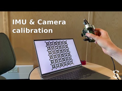
Easiest way to calibrate a camera on Linux. No ROS, no Docker, no CMake. Just @FFmpeg and Spectacular AI command line tool installable via Python pip:
sudo apt install ffmpeg
pip install spectacularAI[full]
sai-cli calibrate your-data.mkv
@Marc_Compere This particular IMU-cam system is used in our internal VIO and VPS test data collection and demonstrations (similar to this one youtu.be/cx9WrKz9-8c )
@907tothe703 Good question. This solution is not suitable for marine navigation, since VIO does not work at sea. Combining IMU / INS with star trackers probably works in the marine context, but it's not the same thing as this method
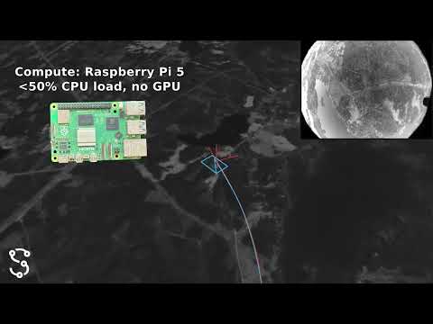
GPS-free visual-inertial navigation in real time on Raspberry Pi 5 with a consumer-grade IMU and camera (and this is not even the slowest CPU this runs on!)
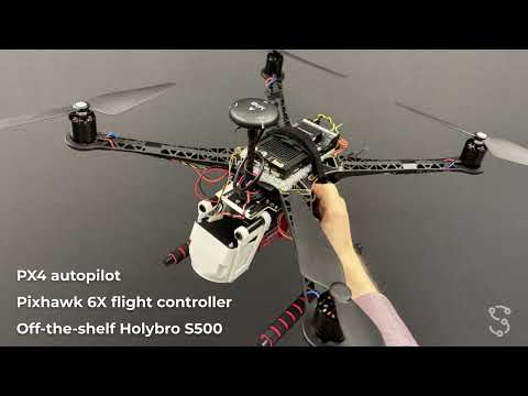
@BradBitler Yes, this can be integrated into ArduPilot, PX4 or other flight controller, but there are a extra hoops that you have to jump through compared to a using a GPS module. We offer commercial support for that kind of integration projects.
@NickParkerPrint This demo used a 100 x 100 km² map, which easily fits into an SD card (a 1 km x 1000 km map would take practically the same space). The ballpark size is "gigabytes" and is adjustable with a few settings that allow balancing between CPU, disk and accuracy.
@oseiskar What's the ratio of data : navigable area here?
Assuming you have either map data or like, latents of map data that you're loading in a mission dependent way right? Like this isn't a pi-sized blob of data that can navigate all of Earth right?