Deelan Jariwala

11.6K posts

Deelan Jariwala banner
Deelan Jariwala

Deelan Jariwala

@WxTca

Incoming graduate student at the University of Alabama - Huntsville, likes the tropics (a lot) UM ‘26 (meteorology, mathematics)

Katılım Eylül 2018
551 Takip Edilen4.2K Takipçiler
Sabitlenmiş Tweet
Deelan Jariwala
Deelan Jariwala@WxTca·
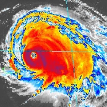
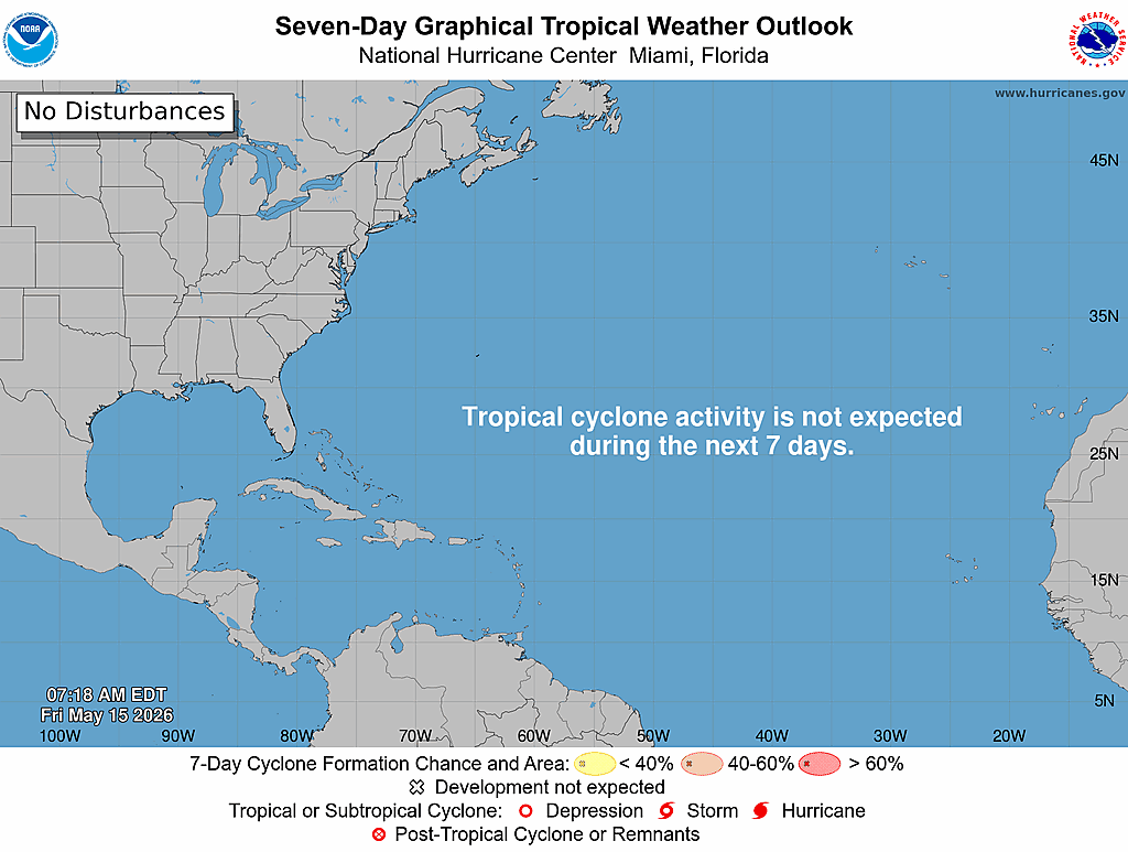
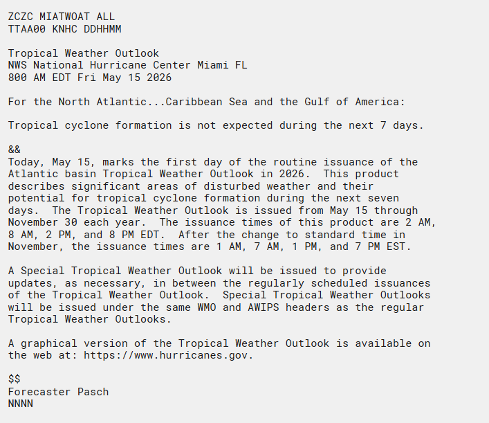
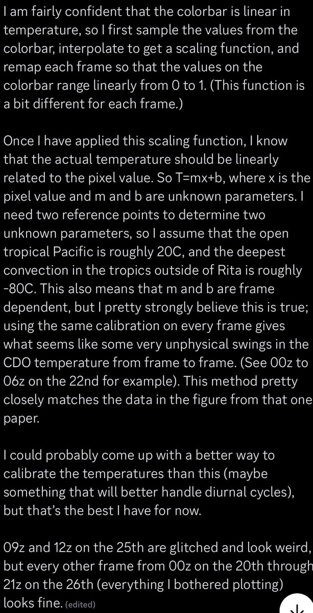
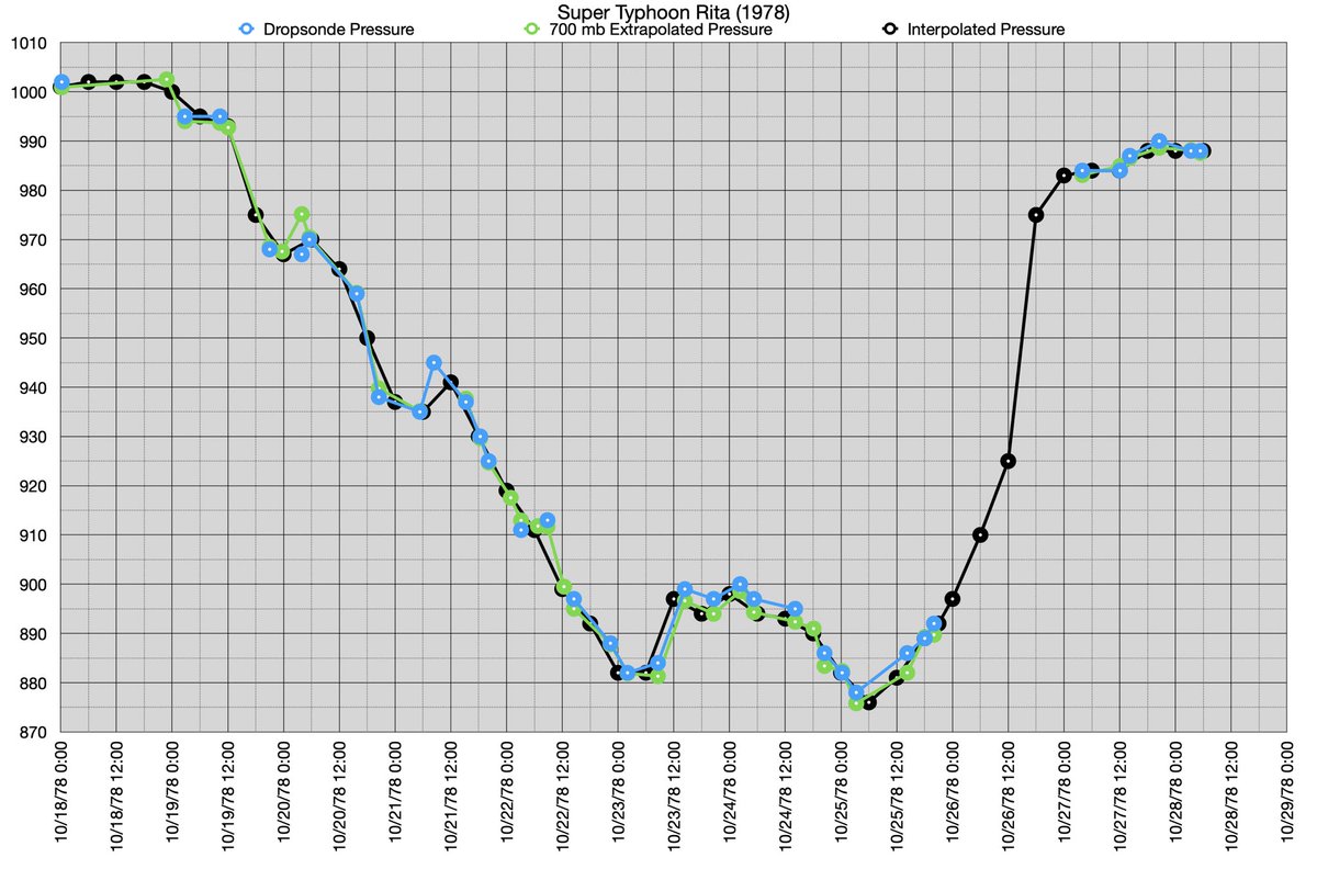
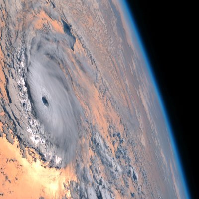
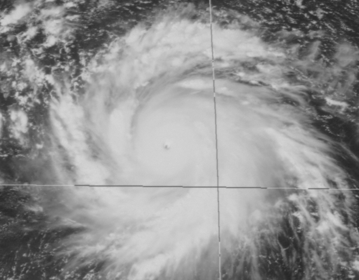
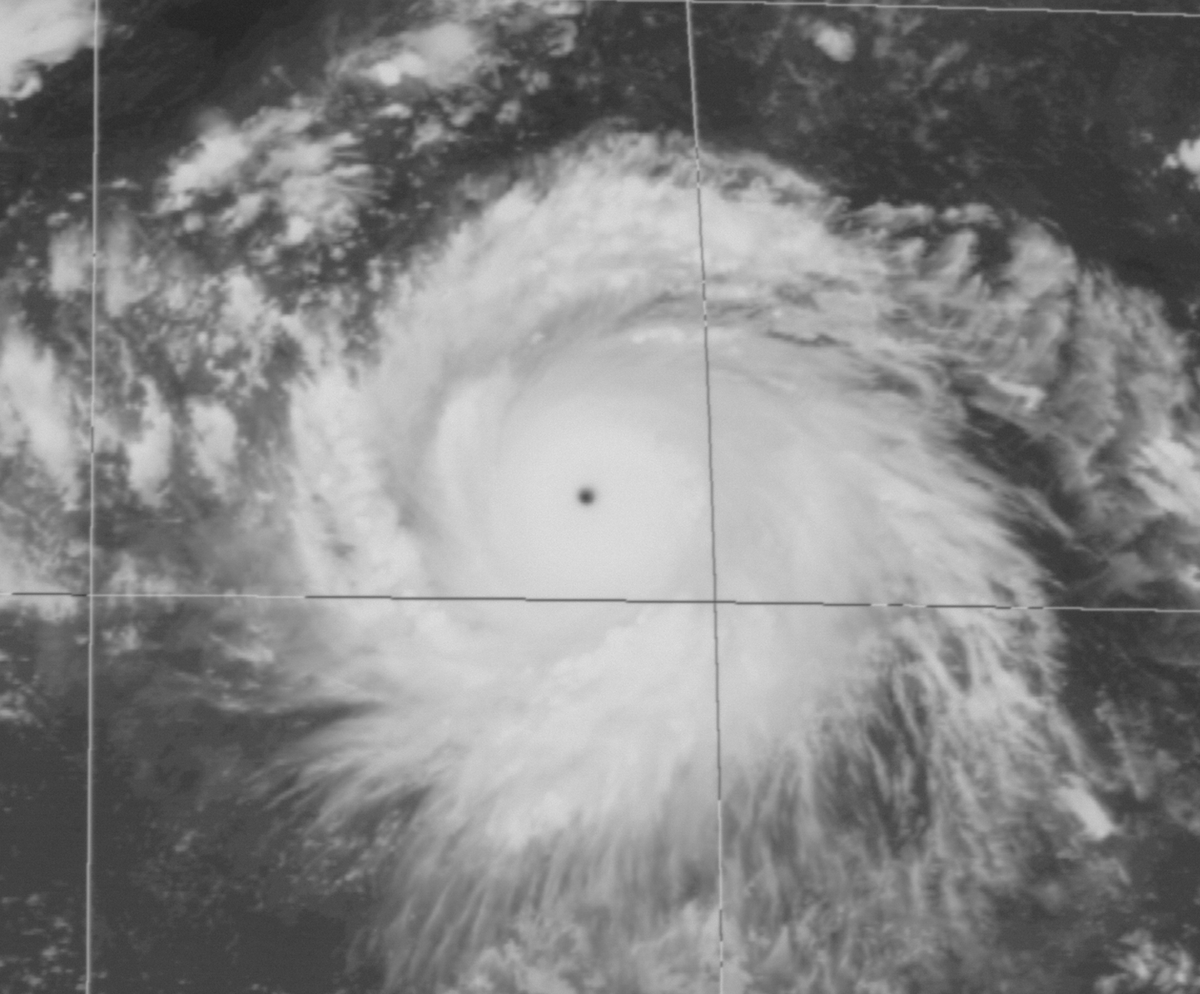
With significant external threats to NOAA, I figured it may be pertinent to discuss what TC forecasting looked like a mere half century ago. All images used in this thread come from the NHC — I will be focusing on 1974’s Hurricane Fifi, at 00z on September 19th.
Deelan Jariwala tweet media
English
9
66
402
47.1K
Deelan Jariwala
Deelan Jariwala@WxTca·
I suspect that the ultimate ceiling of this event may be the highest of any ENSO event in recent history as a result of the sheer amount of heat stored in the ocean over the last several years, because of both AGW and consecutive La Niñas. Remains to be seen if we get there.
Deelan Jariwala tweet media
English
2
3
11
575
Deelan Jariwala
Deelan Jariwala@WxTca·
Vast amounts of heat have been transported into the eastern parts of the Pacific. The heat content in the WPAC is far from being exhausted though, having only been reduced to (roughly) average. There is a lot more heat to be moved still, and the upcoming WWB will likely aid this.
GIF
Deelan Jariwala tweet mediaDeelan Jariwala tweet media
English
1
9
49
1.8K
Andy Hazelton
Andy Hazelton@AndyHazelton·
This website is really cool and a gold mine of historical info for TCs. I wish I had more time to just play around with it. Definitely recommend students or interested folks check it out.
Michael Fischer@MikeFischerWx

TC-ATLAS now features real-time subseasonal and seasonal monitoring pages with interactive diagnostics. Compare how the ongoing evolution differs from historical events and discover their impacts on hurricane activity here: #seasonal" target="_blank" rel="nofollow noopener">michaelfischerwx.github.io/TC-ATLAS/realt…

English
1
3
31
3.4K
Deelan Jariwala retweetledi
Michael Fischer
Michael Fischer@MikeFischerWx·
TC-ATLAS now features real-time subseasonal and seasonal monitoring pages with interactive diagnostics. Compare how the ongoing evolution differs from historical events and discover their impacts on hurricane activity here: #seasonal" target="_blank" rel="nofollow noopener">michaelfischerwx.github.io/TC-ATLAS/realt…
Michael Fischer tweet mediaMichael Fischer tweet mediaMichael Fischer tweet mediaMichael Fischer tweet media
Michael Fischer@MikeFischerWx

Interested in hurricanes? I want to introduce TC-ATLAS: the Tropical Cyclone Analysis Tool for Live and Archived Structure. Explore live or past storms without writing a line of code or downloading a data file, building on the capabilities of TC-RADAR: michaelfischerwx.github.io/TC-ATLAS/index…

English
0
5
34
7.2K
David Birch
David Birch@Climate_Earth20·
There's a lot of noise regarding the coming El Niño, here are 3 of the strongest we have on record. Note that the PDO was favourable on all events being positive. 2026 to date has a negative anomaly, it could change but it won't compliment until winter ❄️❄️
David Birch tweet media
English
4
9
22
1.9K
Deelan Jariwala
Deelan Jariwala@WxTca·
@burgwx Another similar situation is with the 7 sisters constellation. Only 6 of them are visible to the eye today, but tens of thousands of years ago, an observer plausibly could’ve seen the 7th, hence the name
English
1
0
1
155
Tomer Burg
Tomer Burg@burgwx·
Random evening thoughts — it’s possible that events in the past which all records of their existence are gone may be lingering around in a modified form as myths today… (1/2)
English
3
1
36
8.9K
Deelan Jariwala
Deelan Jariwala@WxTca·
@TornadictWx @MatthewCappucci Hmm interesting. With regard to the proposed reasoning — how much of this can be attributed to a faster moving jet being in the right place at the right time?
English
0
0
0
53
Matthew Cappucci
Matthew Cappucci@MatthewCappucci·
A high-altitude jet stream disturbance will serve as the afternoon trigger for storms. A pulse of jet stream energy will be swinging overhead at 40-45 knots. Jet streak translation speeds over 40 knots are frequently associated with significant tornado events. 44 knots 6Z to 0Z.
Matthew Cappucci tweet media
MyRadar Weather@MyRadarWX

MONDAY, May 18 has the makings of a potential Great Plains tornado outbreak. Severe weather risk will extend into the Upper Midwest and Corn Belt as well. Now is the time to review your severe weather plan. Current indications are that extreme thunderstorm fuel will be present ahead of a dryline/cold front combination. The air mass will be primed for explosive development. One uncertainty across Iowa/southeast Minnesota/Wisconsin is whether Sunday night's storms leave behind cool air that reduces thunderstorm fuel. That may ensue, reducing severe weather risk north. Sunday night's storms could also leave behind an outflow boundary (exhaust/wind shift) that would serve as a focal mechanism for storms Monday. TBD. But in southeast Nebraska, central/eastern Kansas, western Missouri and Oklahoma, we expect an upper-echelon severe weather outbreak, with a few significant/strong tornadoes likely. A high-altitude jet stream disturbance will serve as the afternoon trigger for storms. A pulse of jet stream energy will be swinging overhead at 40-45 knots. Jet streak translation speeds over 40 knots are frequently associated with significant tornado events. Beyond the general risk area outlined by the Storm Prediction Center, @MatthewCappucci is especially concerned about southern Kansas and northern Oklahoma. That's where there will be slightly fewer storms since the trigger is only "fringing" the region. But fewer storms = less competition = stronger storms = higher-end supercells. Any supercells that are isolated/discrete around 6 or 7 p.m. Monday will be invigorated by the low-level jet stream, which will ramp up later in the day. That could lead to isolated intense (EF3+) tornado potential. We have a LOT to iron out, but we'll be doing so in the days ahead. Please stay tuned and stay safe.

English
4
17
191
20.6K
Deelan Jariwala retweetledi
National Hurricane Center
National Hurricane Center@NHC_Atlantic·
The first Atlantic Tropical Weather Outlook of 2026 is out. Good news: No tropical cyclone formation is expected over the next 7 days across the Atlantic, Caribbean Sea, or Gulf. Today (May 15) marks the start of daily Tropical Weather Outlooks, issued through Nov 30 at 2 AM, 8 AM, 2 PM, and 8 PM EDT. Stay informed all season long: hurricanes.gov
National Hurricane Center tweet mediaNational Hurricane Center tweet media
English
19
392
1.4K
127.3K
Deelan Jariwala
Deelan Jariwala@WxTca·
@rushtropicalwx Emphasizing uncertainty and hedging can be healthy, when done in a situation that calls for it. I struggle to see why this one does; artificially highlighting uncertainty isn’t particularly productive and tends to undermine a forecast. Talk about the 10% outcome 10% of the time.
English
2
0
4
213
Deelan Jariwala
Deelan Jariwala@WxTca·
@rushtropicalwx The dominant factors are ENSO and the AMO. I think we can lock in a fairly positive ENSO for ASO. Climate models do not suggest a NATL SST pattern that is particularly conducive. Can that change? Sure. But I don’t know anyone who’d forecast that off of purely vibes.
Deelan Jariwala tweet mediaDeelan Jariwala tweet media
English
2
1
12
569
Rush Rush
Rush Rush@rushtropicalwx·
We've had weak El Ninos a d the Atlantic is shutdown. 2009. We've had strong El Nino's that the Atlantic flourished. The key is that there are other factors to consider besides ENSO. Strong vs super El Nino doesnt mean more or less storms in the atlantic at this point.
English
6
0
25
3K
Nikhil Trivedi
Nikhil Trivedi@DCAreaWx·
After 4 of the best years of my life at the University of Wisconsin, I’m excited to say that I’m officially a meteorologist! Although leaving Madison is bittersweet, I’m excited to begin the next chapter as a graduate student at Colorado State University.
Nikhil Trivedi tweet mediaNikhil Trivedi tweet mediaNikhil Trivedi tweet media
English
12
3
99
4.1K
Deelan Jariwala
Deelan Jariwala@WxTca·
A storm centered loop made by the same person. The diurnal pulsing of the cirrus canopy and banding is pretty much textbook. Worth noting that there are significant error bars on the actual estimated brightness temperatures; the gif should be interpreted qualitatively at best.
GIF
English
0
0
13
585
Deelan Jariwala
Deelan Jariwala@WxTca·
Important note on their methodology: The images the JMA provided lacked any real metadata and were merely scanned in microfilm.
Deelan Jariwala tweet media
English
1
0
8
853
Deelan Jariwala
Deelan Jariwala@WxTca·
True! Someone I know (who is much smarter than I am) has been hard at work trying to derive brightness temperature data from the BMPs, using an old JMA paper as a reference. The results are pretty incredible — Rita ‘78 is clearly one of the greatest TCs in the satellite era.
GIF
Ryan Allen@1900hurricane

@Sekai_WX @xiaoqianWX Don't forget @WxTca, he's the one who actually contacted JMA and got the data initially.

English
3
5
100
7K
Cole Stern
Cole Stern@ColeWeather25·
@PROLIFICSHlTTER @WxTca Should be noted that the current Atlantic configuration isn’t too great. We need that to flip or else we may look more like 2022/2025.
English
2
0
2
430
Will
Will@PROLIFICSHlTTER·
H/t @wxtca What really irks me about the El Niño denialism and copium from weenies regarding the imminent strong to super El Niño is the fact that such events are historically followed by robust, multiyear La Niña events. 2027 and 2028 looking like banger seasons already
Will tweet media
English
9
8
69
9.2K
Deelan Jariwala retweetledi
xiaoqianWX
xiaoqianWX@xiaoqianWX·
(1/n) @JMA_kishou provided us with some data of scanned GMS-1 imagery for Typhoon Rita(1978). For the first time ever, it allowed us to see the entire life cycle of this historic system. P1-2 is 10/23 0230UTC, recon observed 882mb Special thanks to @WxTca for contacting JMA!
xiaoqianWX tweet mediaxiaoqianWX tweet mediaxiaoqianWX tweet mediaxiaoqianWX tweet media
English
1
20
66
4.3K